Van Vorst Park

Last updated

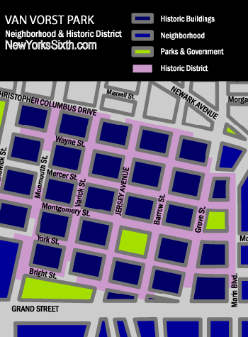
Van Vorst Park Historic District
(Boundary Increase)
Van Vorst Park looking southwest to Jersey Avenue JC,NJ.jpg
Location map of Hudson County, New Jersey.svg
Red pog.svg
USA New Jersey location map.svg
Red pog.svg
Usa edcp location map.svg
Red pog.svg
LocationRoughly bounded by Mercer, Wayne, Montgomery, Grove, Bright, Varick and Monmouth Streets, Jersey City, New Jersey
Coordinates 40°43′7″N74°2′53″W / 40.71861°N 74.04806°W / 40.71861; -74.04806
Area7.7 acres (3.1 ha)
Architectural styleLate 19th And 20th Century Revivals
NRHP reference No. 84000084 [1]
NJRHP No.1540 [2]
Significant dates
Added to NRHPOctober 11, 1984
Designated NJRHPAugust 2, 1978

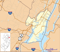
Van Vorst Park is a neighborhood in the Historic Downtown of Jersey City, Hudson County, New Jersey, centered on a park sharing the same name. The neighborhood is located west of Paulus Hook and Marin Boulevard, north of Grand Street, east of the Turnpike Extension, and south of The Village and Christopher Columbus Drive. Much of it is included in the Van Vorst Park Historical District. [3]

Contents

The park was a centerpiece of Van Vorst Township, a township that existed in Hudson County from 1841 to 1851. Van Vorst was incorporated as a township by an Act of the New Jersey Legislature on April 12, 1841, from portions of Bergen Township. On March 18, 1851, Van Vorst Township was annexed by Jersey City. [4]

The name Van Vorst comes from a prominent family in the area, the first of which arrived in the 1630s as superintendent of the patroonship Pavonia, the earliest European settlement on the west bank of the Hudson River in the province of New Netherland. His homestead at Harsimus, plus others at Communipaw, Paulus Hook, Minakwa, Pamrapo were later incorporated into Bergen. His namesake and eighth generation descendant, Cornelius Van Vorst, was the twelfth Mayor of Jersey City serving from 1860 to 1862. [5] [6]

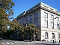
Like Harsimus Cove and Hamilton Park to the north and Bergen-Lafayette to the southwest, the neighborhood contains nineteenth century rowhouses and brownstones. [7] It is home to the Jersey City Free Public Library, James J. Ferris High School (named for the Jersey City citizen who laid the foundation of the Hudson and Manhattan Railroad Powerhouse with his firm Stillman, Delehanty and Ferris), [8] [9] and Old Colony Shopping Plaza. Landmarks include Barrow Mansion and Dixon Mills.

The Grove Street PATH station is located nearby to the north and is the Jersey Avenue (HBLR station) to the south.

Park

Gazebo in Van Vorst Park Gazebo in Van Vorst Park.jpg
Gazebo in Van Vorst Park

Van Vorst Park is a two-acre city park bounded by Barrow Street on the east, Montgomery Street on the north, Jersey Avenue on the west and York Street on the south. The park was renovated in 1999 at a cost of two million dollars with money raised by the Friends of Van Vorst Park. [10]

See also

Images

Related Research Articles

<span class="mw-page-title-main">Paulus Hook</span> Neighborhood of Jersey City, New Jersey, U.S.

Paulus Hook is a community on the Hudson River waterfront in Jersey City, New Jersey. It is located one mile across the river from Manhattan. The name Hook comes from the Dutch word "hoeck", which translates to "point of land." This "point of land" has been described as an elevated area, the location of which today is bounded by Montgomery, Hudson, Dudley, and Van Vorst Streets.

Bergen Township was a township that existed in the U.S. state of New Jersey, from 1661 to 1862, first as Bergen, New Netherland, then as part Bergen County, and later as part of Hudson County. Several places still bear the name: the township of North Bergen; Bergen Square, Old Bergen Road, Bergen Avenue, Bergen Junction, Bergen Hill and Bergen Arches in Jersey City; Bergen Point in Bayonne; and Bergenline Avenue and Bergen Turnpike in North Hudson.

Van Vorst was a township that existed in Hudson County, New Jersey, United States, from 1841 to 1851, that is now a neighborhood in Jersey City. The township was located on the Hudson River, to the west and north of the original territory of Jersey City and across from Manhattan.

<span class="mw-page-title-main">Bergen Square</span> Populated place in Hudson County, New Jersey, US

Bergen Square, at the intersection of Bergen Avenue and Academy Street in Jersey City, is in the southwestern part of the much larger Journal Square district. A commercial residential area, it contains an eclectic array of architectural styles including 19th-century row houses, Art Deco retail and office buildings, and is the site of the longest continually-used school site in the United States. Nearby are the Van Wagenen House and Old Bergen Church, two structures from the colonial period. St. George & St. Shenouda Coptic Orthodox Church founded by early Egyptian immigrants was one of the original Coptic congregations in New Jersey.

<span class="mw-page-title-main">Pavonia, New Netherland</span>

Pavonia was the first European settlement on the west bank of the North River that was part of the seventeenth-century province of New Netherland in what would become the present Hudson County, New Jersey.

<span class="mw-page-title-main">Bergen, New Netherland</span> Origin of the New Jersey settlement

Bergen was a part of the 17th century province of New Netherland, in the area in northeastern New Jersey along the Hudson and Hackensack Rivers that would become contemporary Hudson and Bergen Counties. Though it only officially existed as an independent municipality from 1661, with the founding of a village at Bergen Square, Bergen began as a factory at Communipaw circa 1615 and was first settled in 1630 as Pavonia. These early settlements were along the banks of the North River across from New Amsterdam, under whose jurisdiction they fell.

Oratam was sagamore, or sachem, of the Hackensack Indians living in northeastern New Jersey during the period of early European colonization in the 17th century. Documentation shows that he lived an unusually long life and was quite influential among indigenous and immigrant populations.

Communipaw is a neighborhood in Jersey City in Hudson County, in the U.S. state of New Jersey. It is located west of Liberty State Park and east of Bergen Hill, and the site of one of the earliest European settlements in North America. It gives its name to the historic avenue which runs from its eastern end near Liberty State Park Station through the neighborhoods of Bergen-Lafayette and the West Side that then becomes the Lincoln Highway. Communipaw Junction, or simply The Junction, is an intersection where Communipaw, Summit Avenue, Garfield Avenue, and Grand Street meet, and where the toll house for the Bergen Point Plank Road was situated. Communipaw Cove at Upper New York Bay, is part of the 36-acre (150,000 m2) state nature preserve in the park and one of the few remaining tidal salt marshes in the Hudson River estuary.

<span class="mw-page-title-main">Barrow Mansion</span> Historic house in New Jersey, United States

The Dr. William Barrow Mansion is located at 83 Wayne Street between Barrow Street and Jersey Avenue in Downtown Jersey City, Hudson County, New Jersey, United States. The mansion was added to the National Register of Historic Places on May 2, 1977, and is located within the Van Vorst Park Historic District, which itself was dedicated on March 5, 1980, and is roughly bounded by Railroad Avenue, and Henderson, Grand, Bright, and Monmouth Streets.

<span class="mw-page-title-main">Harsimus</span> Populated place in Hudson County, New Jersey, US

Harsimus is a neighborhood within Downtown Jersey City, Hudson County, in the U.S. state of New Jersey. The neighborhood stretches from the Harsimus Stem Embankment on the north to Christopher Columbus Drive on the south between Coles Street and Grove Street or more broadly, to Marin Boulevard. It borders the neighborhoods of Hamilton Park to the north, Van Vorst Park to the south, the Village to the west, and the Powerhouse Arts District to the east. Newark Avenue has traditionally been its main street. The name is from the Lenape, used by the Hackensack Indians who inhabited the region and could be translated as Crow’s Marsh. From many years, the neighborhood was part of the "Horseshoe", a political delineation created by its position between the converging rail lines and political gerrymandering.

<span class="mw-page-title-main">Hamilton Park, Jersey City</span> Populated place in Hudson County, New Jersey, US

Hamilton Park is a neighborhood in Historic Downtown Jersey City, Hudson County, in the U.S. state of New Jersey, centered on a park with the same name. Hamilton Park is located west of Newport, north of Harsimus Cove, north and east of The Village and south of Boyle Plaza. The Victorian age park is located between Eighth Street and Ninth Street and Hamilton Place on the west and McWilliams Place on the East. Like the Van Vorst Park neighborhood to the south, this quiet park is surrounded by nineteenth century brownstones. The park underwent renovations completed in 2010.

<span class="mw-page-title-main">Jan Everts Bout</span>

Jan Evertsz Bout, was an early and prominent Dutch settler in the 17th century colonial province of New Netherland.

Bergen-Lafayette is a section of Jersey City, New Jersey.

<span class="mw-page-title-main">Historic districts in Hudson County, New Jersey</span> Historic districts in Hudson County, New Jersey, US

Hudson County, New Jersey has historic districts which have been designated as such on a municipal, state, or federal level, or combination therof. Some are listed on New Jersey Register of Historic Places and are included on National Register of Historic Places listings in Hudson County, New Jersey. The following is intended to be a list of places which encompasses an area or group of buildings or structures.

<span class="mw-page-title-main">Newkirk House</span> 17th century house in Jersey City, NJ

The Newkirk House, also known as the Summit House, located at 510 Summit Avenue is the oldest surviving structure in Jersey City, New Jersey. The two-story Dutch Colonial building, composed of sandstone, brick, and clapboard dates to 1690.

<span class="mw-page-title-main">Van Vorst House</span>

The Van Vorst House is a colonial-era residence in Jersey City, New Jersey, USA, located at 531 Palisade Avenue in The Heights. The stone house was built c.1740–1742 by descendants of the first settlers in the region. It is arguably the oldest building in Jersey City.

Abraham Isaacsen Verplanck (1606–1690), also known as Abraham Isaacse Ver Planck, was an early and prominent settler in New Netherlands. A land developer and speculator, he was the progenitor of an extensive Verplanck family in the United States. Immigrating circa 1633, he received a land grant at Paulus Hook in 1638.

References

  1. "National Register Information System". National Register of Historic Places . National Park Service. March 13, 2009.
  2. "New Jersey and National Registers of Historic Places - Hudson County" (PDF). New Jersey Department of Environmental Protection - Historic Preservation Office. July 7, 2009. p. 7. Retrieved August 3, 2010.
  3. Snyder, John P. The Story of New Jersey's Civil Boundaries: 1606-1968, Bureau of Geology and Topography; Trenton, New Jersey; 1969. p. 148. Accessed June 26, 2013.
  4. "Library Guides: Van Vorst Park: Van Vorst Park".
  5. "Library Guides: Van Vorst Homestead Site: Van Vorst Homestead Site".
  6. Hamilton Park Neighborhood and Historic District
  7. JERSEY CITY POWERHOUSE TO UNDERGO FIRST PHASE OF LONG-AWAITED RESTORATION
  8. The Pennsylvania Railroad Harsimus Branch Embankment, Jersey City, NJ Archived 2009-05-23 at the Wayback Machine
  9. "Jersey City, Past and Present".

40°43′06″N74°02′46″W / 40.7183°N 74.0462°W / 40.7183; -74.0462