The Heights, Jersey City

Last updated
Riverview-Fiske Park and the Heights Riverview-Fisk Park Jersey City November 2021 002.jpg
Riverview-Fiske Park and the Heights
The former Public Service Building at Palisade Avenue and Ferry Street Palisade Avenue (Hudson Palisades) at Ferry Street Jersey City Heights.jpg
The former Public Service Building at Palisade Avenue and Ferry Street
Reservoir #3 adjacent to Pershing Field Jcres.jpg
Reservoir #3 adjacent to Pershing Field
Pershing Field Park entrance Pershing Field Park entry JC Heights jeh.JPG
Pershing Field Park entrance
Second Reformed Church, Summit Avenue 2nd RDC JC jeh.jpg
Second Reformed Church, Summit Avenue

The Heights or Jersey City Heights is a neighborhood in Jersey City, New Jersey, located atop the New Jersey Palisades, along the west side of the Hudson River. It is bound by Paterson Plank Road on the north, Highway 139 on the south, Hoboken on the east, and the Hackensack River on the west. [1] [2] and Penhorn Creek on the west. [2] Its postal area ZIP codes are 07307, and portions of 07306. [2]

Contents

Neighborhoods and thoroughfares

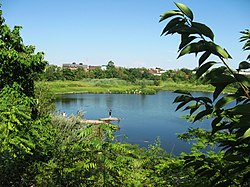
Central Avenue is one of Jersey City's 13 different neighborhood shopping districts. [3] with more than 240 businesses serving the area. [4] Pershing Field (named for General John J Pershing) is a memorial park in the center of the district that was built on a military training ground. It offers a green space, baseball fields, a swimming pool and ice-skating rink. The adjacent Jersey City Reservoir No. 3 has been preserved as a state designated wetland and park. Many stately Victorian and Edwardian homes distinguish the Heights, particularly along Summit Avenue and Sherman Place. [5]

Transportation

An elevator at Congress Street and Paterson Plank Road descends to the 9th Street-Congress Street station of the Hudson-Bergen Light Rail. [5] Mountain Ave [6] and New York Ave are among the streets that run through the area. [7]

History

The Heights was part of the colony of Pavonia, New Netherland, the superintendent of which was the American patriarch of the Van Vorst family. A Van Vorst House built in 1742 by the family (now on Palisade Avenue) is considered to be the oldest building in Hudson County. Summit Avenue, slightly to the west follows an Hackensack Indian trail that became the main road from the villages of Communipaw and Bergen and eventually connected to the Paterson and Hackensack Plank Roads. [8] [9]

E.R.V Wright was the first Mayor of Hudson City. [10]

Filming at the Pathe American studio in Jersey City Heights (1912) Pathe Studio Scene--Director Handworth Posing a Military Drama.jpg
Filming at the Pathé American studio in Jersey City Heights (1912)

In the early 20th century, before Hollywood, the American motion picture industry was mainly based in New Jersey towns along the Hudson River. [11] Chief among them was Fort Lee, which was the nation's first motion picture capital, [12] [13] with other early film studios headquartered in neighboring towns such as Jersey City. [11] Among those was a branch of the French company Pathé, the largest film equipment and production company in the world, whose American factory and studio facility was in established in the Heights in 1910, in a building that still overlooks Paterson Plank Road. Pathé also established the subsidiary Eclectic Film Company, as a distributor for both its American and European product. Although the Jersey City plant produced moderately popular comedies, dramas, and newsreels largely directed at the US market, Perils of Pauline was the first American-made Pathé effort to achieve worldwide success under the Eclectic banner. [14] [15] [16]

Education

Jersey City Public Schools operates public schools in the Heights. [17]

The Roman Catholic Archdiocese of Newark operates area Catholic Schools. St. Anne School was located in Jersey City Heights, and opened in 1904. [18] Its enrollment declined by 33 in 2011 and increased by 22 in 2012. James Carroll, a member of the Jersey City Police Department and a member of the school board, Carroll stated that the 2011 decline was due to parents being afraid that the school would close. [19] In 2011 the archdiocese considered closing the school, but a fundraising generated sufficient money to keep it open. [18] It closed in 2012. [19] That year the building housed the K-8 grades of the Hoboken Charter School on a temporary basis as the regular K-8 building of the charter school was badly damaged by a fire. [20]

See also

Related Research Articles

<span class="mw-page-title-main">New Jersey Route 3</span> State highway in New Jersey, US

Route 3 is a major state highway in the northeastern part of New Jersey. The route runs 10.84 miles (17.45 km) from U.S. Route 46 (US 46) in Clifton, Passaic County to US 1/9 in North Bergen, Hudson County. The route is a divided highway for its entire length, and intersects many major roads, including US 46, which takes travelers to Interstate 80 (I-80) west for commuting out of the city-area, Garden State Parkway and Route 21 in Clifton, Route 17 and the Western Spur of the New Jersey Turnpike (I-95) in East Rutherford, the Eastern Spur of the New Jersey Turnpike in Secaucus, and Route 495 in North Bergen, for traffic going to the Lincoln Tunnel into New York City. Route 3 serves as the main artery to the Lincoln Tunnel from I-80, in conjunction with a portion of US 46 and Route 495. Portions of the route are not up to interstate highway or freeway standards; with businesses, bus stops, and narrow lanes. Despite this, many construction projects over the years have been underway to alleviate this issue. Route 3 also provided access to Hoffmann La Roche's former American headquarters in Nutley, the Meadowlands Sports Complex and American Dream Meadowlands in East Rutherford. The road inspired a story in The New Yorker in 2004 by Ian Frazier due to its views of the Manhattan skyline. Route 3 was originally the Lincoln Tunnel Approach and ended at the state line in the Hudson River, though it was scaled back following the construction of I-495; which is now Route 495 due to also not meeting interstate highway standards.

<span class="mw-page-title-main">Hoboken, New Jersey</span> City in Hudson County, New Jersey, U.S.

Hoboken is a city in Hudson County in the U.S. state of New Jersey. Hoboken is part of the New York metropolitan area and is the site of Hoboken Terminal, a major transportation hub for the tri-state region. As of the 2020 United States census, the city's population was 60,419, an increase of 10,414 (+20.8%) from the 2010 census count of 50,005, which in turn reflected an increase of 11,428 (+29.6%) from the 38,577 counted in the 2000 census. The Census Bureau's Population Estimates Program calculated that the city's population was 58,690 in 2021, ranking the city as the 668th-most-populous in the country. With more than 42,400 inhabitants per square mile (16,400/km2) in data from the 2010 census, Hoboken was ranked as the third-most densely populated municipality in the United States among cities with a population above 50,000. In the 2020 census, the city's population density climbed to more than 48,300 inhabitants per square mile (18,600/km2) of land, ranked fourth in the county behind Guttenberg, Union City and West New York.

<span class="mw-page-title-main">Union City, New Jersey</span> City in Hudson County, New Jersey, United States

Union City is a city in the northern part of Hudson County, in the U.S. state of New Jersey. As of the 2020 United States census, the city was the state's 18th-most-populous municipality, with a population of 68,589, an increase of 2,134 (+3.2%) from the 2010 census count of 66,455. As of the 2010 Census, among cities with a population of more than 50,000, it was the most densely populated city in the United States, with a density of 54,138 per square mile of land. The Census Bureau's Population Estimates Program calculated that the city's population was 65,638 in 2021, ranking the city the 580th-most-populous in the country.

<span class="mw-page-title-main">Weehawken, New Jersey</span> Township in Hudson County, New Jersey, United States

Weehawken is a township in the northern part of Hudson County, in the U.S. state of New Jersey. It is located largely on the Hudson Palisades overlooking the Hudson River. As of the 2020 United States census, the township's population was 17,197, an increase of 4,643 (+37.0%) from the 2010 census count of 12,554, which in turn reflected a decline of 947 (−7.0%) from the 13,501 counted in the 2000 census.

<span class="mw-page-title-main">Hudson–Bergen Light Rail</span> Light rail system in New Jersey, United States

The Hudson–Bergen Light Rail (HBLR) is a light rail system in Hudson County, New Jersey, United States. Owned by New Jersey Transit (NJT) and operated by the 21st Century Rail Corporation, it connects the communities of Bayonne, Jersey City, Hoboken, Weehawken, Union City, and North Bergen.

<span class="mw-page-title-main">9th Street–Congress Street station</span> Station on the Hudson–Bergen Light Rail (HBLR) in Hoboken, New Jersey

9th Street–Congress Street is a station on the Hudson–Bergen Light Rail (HBLR) operated by New Jersey Transit which opened on September 7, 2004. Located at Ninth Street, west of Jackson Street, in Hoboken, New Jersey, the station also serves the Heights of Jersey City. There are two tracks and two side platforms.

Bergen Township was a township that existed in the U.S. state of New Jersey, from 1661 to 1862, first as Bergen, New Netherland, then as part Bergen County, and later as part of Hudson County. Several places still bear the name: the township of North Bergen; Bergen Square, Old Bergen Road, Bergen Avenue, Bergen Junction, Bergen Hill and Bergen Arches in Jersey City; Bergen Point in Bayonne; and Bergenline Avenue and Bergen Turnpike in North Hudson.

Paterson Plank Road is a road that runs through Passaic, Bergen and Hudson Counties in northeastern New Jersey. The route, originally laid in the colonial era, connects the city of Paterson and the Hudson River waterfront. It has largely been superseded by Route 3, but in the many towns it passes it has remained an important local thoroughfare, and in some cases been renamed.

<span class="mw-page-title-main">Hackensack Plank Road</span>

The Hackensack Plank Road, also known as Bergen Turnpike, was a major artery which connected the cities of Hoboken and Hackensack, New Jersey. Like its cousin routes, the Newark Plank Road and Paterson Plank Road, it travelled over Bergen Hill and across the Hackensack Meadows from the Hudson River waterfront to the city for which it was named. It was originally built as a colonial turnpike road as Hackensack and Hoboken Turnpike. The route mostly still exists today, though some segments are now called the Bergen Turnpike. It was during the 19th century that plank roads were developed, often by private companies which charged a toll. As the name suggests, wooden boards were laid on a roadbed in order to prevent horse-drawn carriages and wagons from sinking into softer ground on the portions of the road that passed through wetlands. The company that built the road received its charter on November 30, 1802. The road followed the route road from Hackensack to Communipaw that was described in 1679 as a "fine broad wagon-road."

<span class="mw-page-title-main">Bergen Hill</span> Lower part of the Hudson Palisades, New Jersey, United States

Bergen Hill refers to the lower Hudson Palisades in New Jersey, where they emerge on Bergen Neck, which in turn is the peninsula between the Hackensack and Hudson Rivers, and their bays. In Hudson County, it reaches a height of 260 feet.

<span class="mw-page-title-main">Passaic–Bergen–Hudson Transit Project</span>

The Passaic–Bergen–Hudson Transit Project is a project under study by NJ Transit to reintroduce passenger service on a portion of the New York, Susquehanna and Western Railway (NYSW) right-of-way (ROW) in Passaic, Bergen and Hudson counties using newly built, FRA-compliant diesel multiple unit rail cars. Plans call for service to run from Hawthorne south through Paterson, east to Hackensack and then southeast to North Bergen, where it would join the Hudson-Bergen Light Rail (HBLR).

<span class="mw-page-title-main">Hudson Waterfront</span> Place in Hudson and Bergen

The Hudson Waterfront is an urban area of northeastern New Jersey along the lower reaches of the Hudson River, the Upper New York Bay and the Kill van Kull. Though the term can specifically mean the shoreline, it is often used to mean the contiguous urban area between the Bayonne Bridge and the George Washington Bridge that is approximately 19 miles (31 km) long. Historically, the region has been known as Bergen Neck, the lower peninsula, and Bergen Hill, lower Hudson Palisades. It has sometimes been called the Gold Coast.

<span class="mw-page-title-main">Summit Avenue (Hudson Palisades)</span>

County Route 617 is 4.55 miles (7.32 km) long and follows one street, Summit Avenue along the ridge of the Hudson Palisades in Hudson County, New Jersey. Its southern end is CR 622, or Grand Street, at Communipaw Junction in the Bergen-Lafayette Section of Jersey City. Its northern end is CR 691, 32nd Street, a section of the Bergen Turnpike, in Union City.

<span class="mw-page-title-main">Central Avenue (Hudson Palisades)</span>

Central Avenue is a 12-block-long thoroughfare in the Heights neighborhood of Jersey City, New Jersey, United States. One of 13 shopping districts in the city, it is designated County Route 663 for 1.60-mile (2.57 km) of its length. It originates at the intersection of Summit Avenue and Pavonia Avenue, and runs north, intersecting Newark Avenue one block east of Five Corners to Paterson Plank Road near Transfer Station. The avenue continues north through Union City without the county route designation to 35th Street, two blocks north of Hackensack Plank Road.

<span class="mw-page-title-main">Shippen Street (Weehawken)</span>

Shippen Street is an east-west street in Weehawken, New Jersey. The eastern terminal, a cobblestone double hairpin turn is listed on the New Jersey Register of Historic Places. Shippen Street was developed at the start of the 20th century as part of the Weehawken Heights, one of the town's residential neighborhoods.

<span class="mw-page-title-main">North Hudson County Railway</span>

The North Hudson Railway Company built and operated a streetcar system in Hudson County and southeast Bergen County, New Jersey before and after the start of the 20th century. It was founded by Hillric J. Bonn who became the first President in 1865 and served for 26 years until his death, and eventually taken over by the Public Service Railway. In its endeavors to overcome the formidable obstacle of ascending the lower Hudson Palisades, or Bergen Hill, it devised numerous innovative engineering solutions including funicular wagon lifts, an inclined elevated railway, an elevator and viaducts.

<span class="mw-page-title-main">Palisade Avenue (Hudson Palisades)</span>

Palisade Avenue is the name given to a historic road which parallels the eastern crest of Hudson Palisades in northeastern New Jersey. It travels between Jersey City and Fort Lee, passing through Jersey City Heights, North Hudson, and Cliffside Park, with various parts carrying Hudson and Bergen county route designations. The avenue re-aligns itself at several places along its route as it crosses traditional municipal boundaries created in the 19th century. As a primary route running along the top of the Hudson Palisades, many segments offer scenic views of the Hudson River and the New York skyline.

<span class="mw-page-title-main">Bogota station</span>

Bogota was a railroad station in Bogota, New Jersey, at Court Street/Fort Lee Road west of River Road and east of the Court Street Bridge over the Hackensack River. It was located on the New York, Susquehanna and Western Railway Main Line, which provided passenger service between the 1870s and 1960s.

References

General references

Hudson County New Jersey Street Map. Hagstrom Map Company, Inc. 2008. ISBN   978-0-88097-763-0.

Inline citations

  1. Gittleman, Nicole (January 10, 2023). "A Historical Walking Tour of Jersey City Heights". The Hoboken Girl. Archived from the original on January 11, 2023. Retrieved January 19, 2023.
  2. 1 2 3 "About the Heights". Central Avenue Special Improvement Management Corporation. Archived from the original on December 4, 2022. Retrieved January 19, 2023.
  3. "Jersey City Shopping Districts". 2007. Archived from the original on January 19, 2023. Retrieved January 19, 2023.
  4. "The Heights Section of Jersey City". Central Avenue Special Improvement District. Archived from the original on December 31, 2019. Retrieved March 10, 2019.
  5. 1 2 Olszewski, Anthony. "The Heights Section of Jersey City". GET NJ. Archived from the original on January 19, 2023. Retrieved January 19, 2023.
  6. "Hudson County 7311 straight line diagram" (PDF). New Jersey Department of Transportation. Archived from the original (PDF) on 2012-10-17. Retrieved August 14, 2021.
  7. "Hudson County 6671 straight line diagram" (PDF). New Jersey Department of Transportation . Retrieved August 14, 2021.
  8. Olszewski, Anthony (2002). "From Before the Revolutionary War! Jersey City's Oldest House". City of Jersey City. Archived from the original on May 2, 2021. Retrieved December 13, 2021.
  9. "2012 Jersey City Historic Preservation Month". The Jersey Journal . April 30, 2012. Archived from the original on August 11, 2014. Retrieved December 13, 2021.
  10. "NEW-JERSEY.; The City of Hudson". The New York Times . April 19, 1885. Archived from the original on December 13, 2021. Retrieved December 13, 2021.
  11. 1 2 Kannapell, Andrea (October 4, 1998). "Getting the Big Picture; The Film Industry Started Here and Left. Now It's Back, and the State Says the Sequel Is Huge". The New York Times . Archived from the original on December 19, 2019. Retrieved January 19, 2023.
  12. Amith, Dennis (January 1, 2011). "Before Hollywood There Was Fort Lee, N.J.: Early Movie Making in New Jersey (a J!-ENT DVD Review)". J!-ENT. Archived from the original on December 22, 2019. Retrieved January 19, 2023.
  13. Rose, Lisa (April 29, 2012). "100 years ago, Fort Lee was the first town to bask in movie magic". NJ.com. Archived from the original on September 29, 2018. Retrieved January 19, 2023.
  14. Koszarski, Richard (2004), Fort Lee: The Film Town, Rome, Italy: John Libbey Publishing - CIC srl, ISBN   0-86196-653-8
  15. "Studios and Films". Fort Lee Film Commission. Retrieved May 30, 2011.
  16. Fort Lee Film Commission (2006), Fort Lee Birthplace of the Motion Picture Industry, Arcadia Publishing, ISBN   0-7385-4501-5
  17. "Search for Public School Districts: District Detail for Jersey City Public Schools". National Center for Education Statistics. 2020. Archived from the original on May 15, 2021. Retrieved December 13, 2021.
  18. 1 2 Zeitlinger, Ron (May 22, 2011). "Once doomed, St. Anne's School in Jersey City gets new life". The Jersey Journal . Archived from the original on June 28, 2020. Retrieved January 19, 2023 via NJ.com.
  19. 1 2 Conte, Michaelangelo (2012-02-17). "Newark Archdiocese to close St. Anne's School in Jersey City, Mater Dei Academy in Kearny". The Jersey Journal . Retrieved 2020-06-24.
  20. Thorbourne, Ken (January 18, 2012). "Fire-devastated Hoboken Charter School to reopen in Jersey City Heights". The Jersey Journal . Archived from the original on June 24, 2020. Retrieved June 24, 2020 via NJ.com.

Coordinates: 40°44′51″N74°03′02″W / 40.747376°N 74.050575°W / 40.747376; -74.050575