Bergen Point

Last updated

Bergen Point
Bergen Point barge tow jeh.JPG
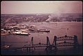
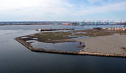
Southwestern tip of Bergen Point
Location map of Hudson County, New Jersey.svg
Red pog.svg
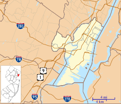
Bergen Point
Bergen Point in Hudson County in New Jersey
Coordinates: 40°38′51″N74°08′29″W / 40.64750°N 74.14139°W / 40.64750; -74.14139
Country United States
State Flag of New Jersey.svg  New Jersey
County Hudson
City Bayonne
Elevation
[1]
7 ft (2 m)
Area code 201
GNIS feature ID874681 [1]

Bergen Point is a point of land that lends its name to the adjacent neighborhood in Bayonne in Hudson County, in the U.S. state of New Jersey. [2] The point is located on the north side of Kill van Kull at Newark Bay. It is the section of the city closest to the Bayonne Bridge. [3] Historically the term has been used more broadly as synonymous with Constable Hook, from which it is geographically separated at Port Johnson.

Contents

History

The area was connected to Staten Island with a ferry as early as the late 17th century, and was later developed as a resort. [4] [5] In the late 18th century it became more prominent as a ferry landing for travelers between New York City and Philadelphia. [6] An 1837 US government coastal survey map identifies it as Vanhorn Point, [7] reflecting the name of a Dutch family that occupied the area just to the north called Pamrapo (among many other spellings, roughly today's Curries Woods neighborhood in Greenville) from the mid-17th century. The Bergen Point Lighthouse, built offshore in 1849, was demolished and replaced with a skeletal tower in the mid 20th century. [8] A charter was granted for the construction of The Jersey City and Bergen Point Plank Road in 1851. [9]

Governor of New Jersey Jon Corzine announced on May 6, 2006, that funding was in place to extend the Hudson-Bergen Light Rail system to Eighth Street. Work was completed and the station opened in January 2011. [10]

A large portion of the point was once site of a Texaco plant, which was cleared and is slated to become a residential and recreational area along Newark Bay and Kill Van Kull. [11] Other former industrial sites are slated for mixed-use development. [12] [13] In 2022, the construction of a major studio at was announced. Called 1888 Studios, it will be the largest in New Jersey. [14] [15]

The renovated Collins Park and walkways along the new developments are part of the Hackensack RiverWalk.

See also

Related Research Articles

<span class="mw-page-title-main">Hudson County, New Jersey</span> County in New Jersey, United States

Hudson County is the smallest and most densely populated county in the U.S. state of New Jersey. It lies west of the lower Hudson River, which was named for Henry Hudson, the sea captain who explored the area in 1609. Part of New Jersey's Gateway Region in the New York metropolitan area, the county seat is Jersey City, which is the county's largest city in terms of both population and area, with a 2020 population of 292,449, and which covered 21.08 square miles (54.6 km2). Since 1990, Hudson County has been one of New Jersey's two fastest-growing counties, along with Ocean County.

<span class="mw-page-title-main">Arthur Kill</span> Navigational channel of the Port of New York and New Jersey

The Arthur Kill is a tidal strait in the New York–New Jersey Harbor Estuary between Staten Island, New York and Union and Middlesex counties, New Jersey. It is a major navigational channel of the Port of New York and New Jersey.

<span class="mw-page-title-main">Kill Van Kull</span> Tidal strait between Staten Island, New York and Bayonne, New Jersey, United States

<span class="mw-page-title-main">Newark Bay</span> Estuary on the coast of New Jersey, United States

Newark Bay is a tidal bay at the confluence of the Passaic and Hackensack Rivers in northeastern New Jersey. It is home to the Port Newark-Elizabeth Marine Terminal, the largest container shipping facility in Port of New York and New Jersey, the second busiest in the United States. An estuary, it is periodically dredged to accommodate seafaring ships.

<span class="mw-page-title-main">New York–New Jersey Harbor Estuary</span> One of the most intricate natural harbors in the world

The New York–New Jersey Harbor Estuary, also known as the Hudson-Raritan Estuary, is in the northeastern states of New Jersey and New York on the East Coast of the United States. The system of waterways of the Port of New York and New Jersey forms one of the most intricate natural harbors in the world and one of the busiest ports of the United States. The harbor opens onto the New York Bight in the Atlantic Ocean to the southeast and Long Island Sound to the northeast.

<span class="mw-page-title-main">Hackensack River</span> River in the U.S. states of New York and New Jersey

The Hackensack River is a river, approximately 45 miles (72 km) long, in the U.S. states of New York and New Jersey, emptying into Newark Bay, a back chamber of New York Harbor. The watershed of the river includes part of the suburban area outside New York City just west of the lower Hudson River, which it roughly parallels, separated from it by the New Jersey Palisades. It also flows through and drains the New Jersey Meadowlands. The lower river, which is navigable as far as the city of Hackensack, is heavily industrialized and forms a commercial extension of Newark Bay.

<span class="mw-page-title-main">Constable Hook</span> Populated place in Hudson County, New Jersey, US

Constable Hook is a cape located on the north side of the outlet of Kill van Kull into Upper New York Bay in Bayonne, New Jersey. The cape has long been an important site of marine transfer operations in the Port of New York and New Jersey. Just offshore, Robbins Reef Light serves to guide harbor traffic. Since the late 20th century, brownfields have been repurposed for recreational and commercial uses.

The Newark Plank Road was a major artery between Hudson Waterfront at Paulus Hook and city of Newark further inland across the New Jersey Meadows. As its name suggests, a plank road was constructed of wooden planks laid side-to-side on a roadbed. Similar roads, the Bergen Point Plank Road, the Hackensack Plank Road and Paterson Plank Road, traveled to the locales for which they are named. The name is no longer used, the route having been absorbed into other streets and freeways.

<span class="mw-page-title-main">Bergen Hill</span> Lower part of the Hudson Palisades, New Jersey, United States

Bergen Hill refers to the lower Hudson Palisades in New Jersey, where they emerge on Bergen Neck, which in turn is the peninsula between the Hackensack and Hudson Rivers, and their bays. In Hudson County, it reaches a height of 260 feet.

<span class="mw-page-title-main">Hudson River Waterfront Walkway</span> Park in the United States of America

The Hudson River Waterfront Walkway, also known as the Hudson River Walkway, is a promenade along the Hudson Waterfront in New Jersey. The ongoing and incomplete project located on Kill van Kull and the western shore of Upper New York Bay and the Hudson River was implemented as part of a New Jersey state-mandated master plan to connect the municipalities from the Bayonne Bridge to the George Washington Bridge with an urban linear park and provide contiguous unhindered access to the water's edge.

<span class="mw-page-title-main">Hackensack River Greenway</span> Trail along the lower Hackensack River

Hackensack River Greenway, once known as the Hackensack RiverWalk, a is partially constructed greenway along the Newark Bay and Hackensack River in Hudson County, New Jersey, United States.

<span class="mw-page-title-main">Bergen, New Netherland</span> Origin of the New Jersey settlement

Bergen was a part of the 17th century province of New Netherland, in the area in northeastern New Jersey along the Hudson and Hackensack Rivers that would become contemporary Hudson and Bergen Counties. Though it only officially existed as an independent municipality from 1661, with the founding of a village at Bergen Square, Bergen began as a factory at Communipaw circa 1615 and was first settled in 1630 as Pavonia. These early settlements were along the banks of the North River across from New Amsterdam, under whose jurisdiction they fell.

<span class="mw-page-title-main">Bergen Neck</span> Peninsula in northeastern New Jersey, United States

Bergen Neck is the peninsula between the Upper New York Bay and the Newark Bay in the Hudson County, New Jersey municipalities of Bayonne and Jersey City. Its southernmost tip, Bergen Point, is separated from Staten Island by the Kill van Kull, which is crossed by the Bayonne Bridge.

Curries Woods is a neighborhood in the southern part of Greenville in Jersey City, New Jersey bordering Bayonne. It was named after James Curie, who was on the town Committee for Greenville when it was its own Township in the 19th century. The area remained rural until the later part of the century when the Central Railroad of New Jersey built a line connecting ferries to Elizabeth, New Jersey and New York City. Currie's Woods still remained untouched through the late part of the century and it was valued for its woods, rocky shore and dunes on Newark Bay. A lot of the land was eventually lost, but a tract was set aside in the early part of the 20th century. A small cemetery, the Old Greenville Cemetery, was nearby. This park lost much of its land to the city's largest Housing Authority project in 1959, except a small tract in Bayonne, Mercer Park.

<span class="mw-page-title-main">Hudson Waterfront</span> Place in Hudson and Bergen

The Hudson Waterfront is an urban area of northeastern New Jersey along the lower reaches of the Hudson River, the Upper New York Bay and the Kill van Kull. Though the term can specifically mean the shoreline, it is often used to mean the contiguous urban area between the Bayonne Bridge and the George Washington Bridge that is approximately 19 miles (31 km) long. Historically, the region has been known as Bergen Neck, the lower peninsula, and Bergen Hill, lower Hudson Palisades. It has sometimes been called the Gold Coast.

<span class="mw-page-title-main">Bergen Point Plank Road</span>

The Jersey City and Bergen Point Plank Road was a road originally built in the 19th century in Hudson County, New Jersey, United States which ran between Paulus Hook and Bergen Point. The company that built the road received a charter on March 6, 1850 to improve one that had been built in the 18th century. It has subsequently become Grand Street and Garfield Avenue in Jersey City and Broadway in Bayonne. Plank roads were built during the 19th century, often by private companies as turnpike roads, in this case with a tollgate at Communipaw Junction. As the name suggests, wooden boards were laid on a roadbed in order to prevent horse-drawn carriages and wagons from sinking into softer ground on the portions of the road.

<span class="mw-page-title-main">1888 Studios</span>

1888 Studios is a proposed film and television studio planned to be built on a 70 acres (28 ha) site at Bergen Point in Bayonne, New Jersey. Its name is a nod to the year the movie camera was invented.

<span class="mw-page-title-main">Collins Park (Bayonne, New Jersey)</span>

Collins Park, or 1st Street Park, is the largest municipal park in Bayonne, New Jersey. It is located at the southern end of the city and runs for 0.75 miles (1.21 km) along the shore the Kill van Kull. Once known as Kill van Kull Park, it is named for Dennis P. Collins, who served at mayor of Bayonne from 1974 to 1990. The approach to the Bayonne Bridge crosses over the park at the west, under which will connect to the planned extension of Hackensack River Greenway at Bergen Point.

References

  1. 1 2 "Bergen Point". Geographic Names Information System . United States Geological Survey, United States Department of the Interior.
  2. Locality Search Archived July 9, 2016, at the Wayback Machine , State of New Jersey. Accessed February 7, 2015.
  3. Hudson County New Jersey Street Map. Hagstrom Map Company, Inc. 2008. ISBN   978-0-88097-763-0.
  4. Bergen Point [ permanent dead link ]
  5. "Hotel Latourette: The Most Fashionable Resort in the Suburban District of New York". Hagley. February 6, 2013. Retrieved November 3, 2016.
  6. Paulus Hook Ferry
  7. NOAA Coastal Survey file T18.jpg, available at and attached to Wikipedia article on Curries Woods.
  8. Bergen Point Lighthouse, 1849-1949, New Jersey Lighthouse Society.
  9. Laws of the State of New Jersey, 1811, pp. 337–340
  10. Frassinelli, Mike. "NJ Transit opens Bayonne 8th Street Station, extending Hudson-Bergen Light Rail service", The Star-Ledger , January 31, 2011. Accessed August 25, 2013.
  11. 1,200 housing units, recreation facilities planned for former Texaco site in Bayonne Jersey Journal, Sept 2015
  12. "Eyesores no more?". November 26, 2020.
  13. "Public hearing for Bayview development slated for October". September 15, 2021.
  14. "Bayonne Planning Board approves 1888 Studios at former Texaco site". March 31, 2022.
  15. "Renderings Revealed for NJ's Largest Film Production Complex in Bayonne". March 25, 2022.
  16. "Part of What the World Did not Know Until Now" (PDF). Bayonne Public Library. November 19, 1946.