Greater Hartford

Last updated
Greater Hartford
Hartford-West Hartford, CT CSA
Hartford CT.JPG
New Britain.jpg
Blue Back Square in West Hartford, Connecticut 2, August 10, 2008.jpg
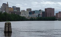
Top to bottom: Skylines of Hartford, New Britain, and West Hartford
Map of Connecticut highlighting Hartford-West Hartford.svg
CountryFlag of the United States.svg United States
State(s)
Principal cities
Area
  Total3,923 sq mi (10,160 km2)
Population
 (2020)
  Total1,482,086 (CSA)
  Rank Ranked 41st in the US for Combined Statistical Areas
GDP
[1]
  MSA$114.887 billion (2022)
Time zone EST
Area code(s) 860, 959

Greater Hartford is a region located in the U.S. state of Connecticut, centered on the state's capital of Hartford. It represents the only combined statistical area in Connecticut defined by a city within the state, being bordered by the Greater Boston region to the northeast and New York metropolitan area to the south and west. [2] Sitting at the southern end of the Metacomet Ridge, its geology is characterized by land of a level grade along the shores of Connecticut River Valley, with loamy, finer-grained soil than other regions in the state. Greater Hartford (the metropolitan area as defined by the U.S. Census Bureau), had a total population of 1,213,531 at the 2020 United States census.

Contents

Hartford's role as a focal point for the American insurance industry is known nationally. The metropolitan area's affluence and its vibrant music and arts scene define the region's culture. The region's economy is closely tied with Springfield, Massachusetts, with both cities being served by Bradley International Airport and with their shared presence within the Knowledge Corridor, being only 25 miles apart. The area is also served by the smaller Hartford-Brainard Airport.

Definitions

New England City and Town Area

New England City and Town Areas (NECTA) are cluster of cities and towns throughout all of New England defined by the Office of Management and Budget. The Hartford-East Hartford-Middletown, CT Metropolitan NECTA consists of 54 towns, including 25 in Hartford County, 5 in Litchfield County, 6 in Middlesex County, 2 in New London County, 12 in Tolland County, and 4 in Windham County.

Metropolitan statistical area

Historical population
CensusPop.Note
1900 195,480
1910 250,18228.0%
1920 336,02734.3%
1930 421,09725.3%
1940 450,1896.9%
1950 539,66119.9%
1960 847,15757.0%
1970 1,034,99322.2%
1980 1,051,6061.6%
1990 1,123,6786.9%
2000 1,148,6182.2%
2010 1,212,3815.6%
2020 1,213,5310.1%
U.S. Decennial Census [3] [4]

The United States Census Bureau also defines the Hartford–East Hartford–Middletown, CT Metropolitan Statistical Area (MSA) based on towns as building blocks. The area contains 54 towns of Hartford County, Tolland County, and Middlesex County. [5] The 2015 population estimate for the MSA is 1,211,324, [6] and is ranked as the 47th-largest metropolitan area by population in the United States. The MSA definition of the area contains a significant portion of the Lower Connecticut River Valley, which is not commonly considered as part of Greater Hartford.[ citation needed ]

A region very similar to the MSA is covered by the combination of the Hartford Service Delivery Area and the Mid-Connecticut Service Delivery Area, covering 56 towns. [7]

County 2021 estimate2020 censusChangeAreaDensity
Hartford County 896,854899,498−0.29%734.93 sq mi (1,903.5 km2)
Middlesex County 164,759164,245+0.31%369.30 sq mi (956.5 km2)
Tolland County 150,293149,788+0.34%410.35 sq mi (1,062.8 km2)
Total1,211,9061,213,531−0.13%1,514.58 sq mi (3,922.7 km2)

List of municipalities

100,000 or more inhabitants
50,000 to 100,000 inhabitants
10,000 to 50,000 inhabitants
1,000 to 10,000 inhabitants
Fewer than 1,000 inhabitants

^1 Town also included in the Springfield, Massachusetts NECTA

Economy

Notable companies based in Hartford city proper

The Aetna headquarters in Hartford Aetna building in Hartford.gk.jpg
The Aetna headquarters in Hartford
The iconic "boat building" in downtown Hartford is home to The Phoenix Companies Boat Building, Hartford CT.jpg
The iconic "boat building" in downtown Hartford is home to The Phoenix Companies

Notable companies based in surrounding towns

^2 Division of United Technologies (Otis and Carrier are under the UTC Building & Industrial Systems division)

Higher education

Public colleges and universities

Public, four-year universities in the area include:. [30] [31]

Aerial view of the UConn's main campus UCONNfromsky.jpg
Aerial view of the UConn's main campus

Community and technical colleges

Public, two-year community colleges in the area include: [30]

Private colleges and universities

Private, nonprofit, four-year universities in the area include: [32]

Trinity College Chapel Trincollchapel.jpg
Trinity College Chapel

Healthcare

There are numerous hospitals in the Greater Hartford area, including five teaching hospitals (of which, one is a pediatric hospital) and two psychiatric hospitals.

Teaching hospitals

Saint Francis Hospital & Medical Center St. Francis Hospital, 114 Woodland Street in Hartford, Connecticut, 2009-09-02.jpg
Saint Francis Hospital & Medical Center

All of the above hospitals are affiliated with the University of Connecticut School of Medicine [33]

Psychiatric hospitals

Culture and attractions

Performing arts

The Bushnell Center for the Performing Arts at night The Bushnell outside high res photo.jpg
The Bushnell Center for the Performing Arts at night

The Bushnell Center for the Performing Arts is one of the largest indoor performing arts venues in the area. It houses two theaters within the complex: the 2,800-seat Mortensen Hall and the 906-seat Belding Theater, and is home to the Hartford Symphony Orchestra, the premiere orchestra in Connecticut. Other theaters in the area include the Hartford Stage and TheaterWorks.

The area is also home to the Xfinity Theatre, a 7,500-seat open-air amphitheater. The lawn outside the theater is capable of holding roughly 22,500 people, bringing total capacity to around 30,000 people.

Conventions and exhibitions

The Connecticut Convention Center is located in downtown Hartford adjacent to the Hartford Marriot Downtown. The facility has more than 140,000 square feet (13,000 m2) of exhibition space, a 40,000-square-foot (4,000 m2) ballroom, and 25,000 square feet (2,300 m2) of space for meetings and conferences. Since 2005, it has hosted ConnectiCon, an annual, multi-genre, pop culture convention. [34]

The New England Air Museum in Windsor Locks also hosts many events, with three large hangars available for use. One of the more popular events held there is FlightSimCon.

In addition, AOPA has held their annual aviation summit in Hartford. [35]

Notable museums

Old State House, Hartford CT - front facade.JPG
Front facade of the Old State House
WadsworthHartford.jpg
Wadsworth Atheneum in the wintertime

Sports

Greater Hartford is home to multiple minor league professional sports teams and college teams. There are currently no major league professional sports teams. However, it was home to the Hartford Whalers ice hockey team from 1974 to 1997. The Whalers came to Hartford playing in the World Hockey Association, until they were admitted to the National Hockey League in 1979. In 1997, the team relocated to North Carolina, where they were renamed the Carolina Hurricanes.

Pratt & Whitney Stadium at Rentschler Field Rentschler Field UConn.jpg
Pratt & Whitney Stadium at Rentschler Field

Throughout the mid-1990s, the New England Patriots were negotiating with the state of Connecticut for a brand new football stadium located in downtown Hartford to replace the aging Foxboro Stadium where they played. The team eventually agreed to another proposal that saw the construction of Gillette Stadium. With the Patriots no longer in the equation, the state instead decided to construct a smaller football stadium on the former United Technologies-owned airfield in East Hartford. Pratt & Whitney Stadium at Rentschler Field seats approximately 40,000 spectators and is home to the Connecticut Huskies football team.

Professional sports teams

ClubSportLeagueVenue
Hartford Wolf Pack Ice Hockey AHL XL Center
Hartford Yard Goats Baseball Eastern League Dunkin' Donuts Park
Hartford Athletic Soccer USL Championship Dillon Stadium

Collegiate sports teams

TeamSchoolDivisionConference
Central Connecticut Blue Devils Central Connecticut State University NCAA Division I Northeast Conference
Connecticut Huskies University of Connecticut NCAA Division I Big East Conference
Hartford Hawks University of Hartford NCAA Division I America East Conference
Saint Joseph Blue Jays University of Saint Joseph NCAA Division III Little East Conference
Trinity Bantams Trinity College NCAA Division III NESCAC
Wesleyan Cardinals Wesleyan University NCAA Division III NESCAC

Greater Hartford is also home to the Travelers Championship golf tournament (formerly known as the Greater Hartford Open/Buick Championship).

Shopping centers

Entrance to the Westfarms Mall WestFarms mall entrance, Connecticut.jpg
Entrance to the Westfarms Mall
Headquarters of the Hartford Courant The Hartford Courant building in downtown Hartford, seen from I-84 East.jpg
Headquarters of the Hartford Courant

Major shopping centers in the area include:

Media

Print

The Hartford Courant is the daily broadsheet newspaper serving the Greater Hartford area. Founded in 1764 as the Connecticut Courant, it is generally considered to be the oldest continually published newspaper in the United States. It is owned by Tribune Publishing.

From 1817 to 1976, the area was also served by another daily newspaper, the Hartford Times .

Television

Greater Hartford and Greater New Haven form a single television market. This television market is served by the following broadcast television stations:

English language
Spanish language

Transportation

Road

I91 Connecticut.jpg
I-91 has HOV lanes in both directions between Hartford and Windsor
Bulkeley Bridge in Hartford CT.jpg
The Bulkeley Bridge carries I-84 across the Connecticut River
I-384 in Manchester CT.JPG
I-384 looking east from Exit 3 in Manchester, Connecticut
Connecticut Route 2 entering Hartford.gk.jpg
Westbound on Route 2 at its interchange with I-84

Interstate highways

Highway transportation in Greater Hartford is primarily run by two mainline Interstates:

There were several plans to expand the highway system (with at least one plan calling for a full beltway). Various plans encountered resistance due to budgetary and environmental concerns. However, some highways were ultimately constructed, if only partially:

  • I-291.svg I-291 (serves as the northeastern portion of the partial beltway)
  • I-384.svg I-384 (spur route into eastern Connecticut)
  • I-691.svg I-691 (originally a connection to Willimantic)

U.S. Routes

In the area, four major U.S. Routes serve the area's towns/cities:

Other major expressways

Some state highways also serve as major expressways:

Bus

Public bus transportation is operated by the Hartford division of CTTransit. It provides service to 30 local routes and 12 express routes seven days a week throughout the metropolitan area. [36]

2015 saw the opening of the CTfastrak, a bus rapid transit system that runs from downtown New Britain to Hartford Union Station. The dedicated busway is over 9 miles long and stops at 10 stations. [37] [38] [39]

Airport

Bradley International Airport ( IATA : BDL, ICAO : KBDL, FAA LID : BDL) is located in the town of Windsor Locks, approximately 10 miles from Hartford. Bradley is the second-largest airport in New England (behind Logan International Airport), and was ranked the 55th busiest airport in the United States in 2008. [40] [41] Southwest Airlines, Delta Air Lines, JetBlue Airways, and US Airways account for more than half of the airport's passenger traffic. [42] [43] The Bradley Airport Connector provides highway access to the airport from Interstate 91.

Bradley is a dual-use civil/military airport, with the Bradley Air National Guard Base serving as the home of the Connecticut Air National Guard 103d Airlift Wing.

Hartford–Brainard Airport ( IATA : HFD, ICAO : KHFD, FAA LID : HFD) is a smaller reliever airport located in the southeastern section of Hartford. It is primarily used for general aviation purposes. [44]

Rail

Several Amtrak routes run through the metropolitan area, including the Northeast Regional , Vermonter , as well as a daily shuttle between New Haven and Springfield, Massachusetts.

The Hartford Line is a commuter rail service between New Haven, Connecticut, and Springfield, Massachusetts, using the Amtrak-owned New Haven–Springfield Line. CTrail-branded trains provide service along the corridor, and riders can use Hartford Line tickets to travel on board most Amtrak trains along the corridor at the same prices. The service launched on June 16, 2018.

CTTRANSIT Htfd NewFlyer 538.JPG
CT Transit bus on Main Street in Hartford
Hartford-Brainard Airport CT - 23 Apr 1990.jpg
Aerial image of Hartford-Brainard Airport

Related Research Articles

<span class="mw-page-title-main">Hartford, Connecticut</span> Capital city of Connecticut, U.S.

Hartford is the capital city of the U.S. state of Connecticut. The city, located in Hartford County, had a population of 121,054 as of the 2020 census. Hartford is the most populous city in the Capitol Planning Region and the core city of the Greater Hartford metropolitan area.

<span class="mw-page-title-main">Hartford County, Connecticut</span> County in Connecticut, United States

Hartford County is a county located in the north central part of the U.S. state of Connecticut. According to the 2020 census, the population was 899,498, making it the second-most populous county in Connecticut. Hartford County contains the city of Hartford, the state capital of Connecticut and the county's most populous city, with 121,054 residents at the 2020 census. Hartford County is included in the Hartford-East Hartford-Middletown metropolitan statistical area.

<span class="mw-page-title-main">East Windsor, Connecticut</span> Town in Connecticut, United States

East Windsor is a town in Hartford County, Connecticut, United States. The town is part of the Capitol Planning Region. The population was 11,190 at the 2020 census. The town has five villages: Broad Brook, Melrose, Scantic, Warehouse Point and Windsorville.

<span class="mw-page-title-main">Farmington, Connecticut</span> Town in Connecticut, United States

Farmington is a town in Hartford County in the Farmington Valley area of central Connecticut in the United States. The town is part of the Capitol Planning Region. The population was 26,712 at the 2020 census. It sits 10 miles west of Hartford at the hub of major I-84 interchanges, 20 miles south of Bradley International Airport and two hours by car from New York City and Boston. It has been home to the world headquarters of several large corporations including Otis Elevator Company, United Technologies, and Carvel. The northwestern section of Farmington is a suburban neighborhood called Unionville.

<span class="mw-page-title-main">Windsor, Connecticut</span> Town in Connecticut, United States

Windsor is a town in Hartford County, Connecticut, United States, and was the first English settlement in the state. It lies on the northern border of Connecticut's capital, Hartford. The town is part of the Capitol Planning Region. The population of Windsor was 29,492 at the 2020 census.

<span class="mw-page-title-main">Ellington, Connecticut</span> Town in Connecticut, United States

Ellington is a town in Tolland County, Connecticut, United States. Ellington was incorporated in May 1786, from East Windsor. The town is part of the Capitol Planning Region. As of the 2020 census, the town population was 16,426.

<span class="mw-page-title-main">New Britain, Connecticut</span> City in Connecticut, United States

New Britain is a city in Hartford County, Connecticut, United States. It is located approximately 9 miles (14 km) southwest of Hartford. The city is part of the Capitol Planning Region. According to 2020 Census, the population of the city is 74,135.

<span class="mw-page-title-main">Bradley International Airport</span> Airport near Hartford, Connecticut, USA

Bradley International Airport is a public international airport in Windsor Locks, Connecticut, United States. Owned and operated by the Connecticut Airport Authority (CAA), it is the second-largest airport in New England.

<span class="mw-page-title-main">Greater New Haven</span> Metropolitan statistical area in Connecticut, United States

Greater New Haven is the metropolitan area whose extent includes those towns in the U.S. state of Connecticut that share an economic, social, political, and historical focus on the city of New Haven. It occupies the south-central portion of the state, in a radius around New Haven.

<span class="mw-page-title-main">Hartford–Springfield</span> Conurbation in the United States

The greater Hartford–Springfield area is an urban region and surrounding suburban areas that encompasses both north-central Connecticut and the southern Connecticut River Valley in western Massachusetts; its major city centers are Springfield, Massachusetts and Hartford, Connecticut.

<span class="mw-page-title-main">Greater Bridgeport</span> Metropolitan statistical area in Connecticut, United States

Stamford-Bridgeport-Norwalk is a metropolitan area in the U.S. state of Connecticut. The area is located in Southwestern Connecticut. In its most conservative form the area consists of the city of Bridgeport and five surrounding towns—Easton, Fairfield, Monroe, Stratford, and Trumbull. This definition of the Stamford area has a population of more than 305,000 and is within the Stamford -Bridgeport-Norwalk-Danbury metropolitan statistical area, which consists of all of Fairfield County, Connecticut. The estimated 2015 county population was 948,053. The area is numbered as part of the New York-Newark Combined Statistical Area NY-NJ-CT-PA by the United States Census Bureau.

<span class="mw-page-title-main">CT Transit Hartford</span>

CT Hartford is the largest division of Connecticut Transit, providing service on 43 local routes, 5 "flyer" limited stop routes and 18 express routes throughout 27 towns in Hartford County, including Bloomfield, East Hartford, Farmington, Glastonbury, Manchester, Middletown, Newington, New Britain, Rocky Hill, South Windsor, West Hartford, Wethersfield and Windsor, in addition to Hartford. Service is provided seven days a week in the region, with routes centered on Hartford. The Hartford Division provides connections with local routes in Bristol and New Britain.

<span class="mw-page-title-main">CT Transit New Britain & Bristol</span>

CT New Britain Division and CT Bristol Division is one division of Connecticut Transit that collectively provides local bus service to four towns in the Central Connecticut Region with connections to CT Transit Hartford Division in downtown New Britain, downtown Bristol, along the Berlin Turnpike, at UConn Health, at Tunxis Community College, CT Transit Waterbury Division and Middletown Area Transit in Cromwell. Service in both divisions operates daily along 13 routes.

<span class="mw-page-title-main">Providence metropolitan area</span> Metropolitan statistical area in the United States

The Providence metropolitan area is a region extending into eight counties in two states. Its core is in the states of Rhode Island and Massachusetts, and it is the 38th largest metropolitan area in the United States. The largest city in the Providence MSA is Providence, Rhode Island, with an estimated population of 1,622,520, exceeding that of Rhode Island by slightly over 60%. The MSA covers all of Rhode Island and Bristol County, Massachusetts, with an average population density of 2300 per mi2.

<span class="mw-page-title-main">Portland metropolitan area, Maine</span> Metropolitan area in United States of America

The city of Portland, Maine, is the hub city of a metropolitan area in southern Maine. The region is commonly known as Greater Portland or the Portland metropolitan area. For statistical purposes, the U.S. federal government defines three different representations of the Portland metropolitan area. The Portland–South Portland, Maine, metropolitan statistical area is a region consisting of three counties in Maine, anchored by the city of Portland and the smaller city of South Portland. As of the 2020 census, the MSA had a population of 551,740. A larger combined statistical area (CSA), the Portland–Lewiston–South Portland combined statistical area, is defined as the combination of this metropolitan statistical area (MSA) with the adjacent Lewiston–Auburn MSA. The CSA comprises four counties in southern Maine. The Portland–South Portland metropolitan New England city and town area is defined on the basis of cities and towns rather than entire counties. It consists of most of Cumberland and York counties plus the town of Durham in Androscoggin County. The Greater Portland area has emerged as an important center for the creative economy, which is also bringing gentrification.

<span class="mw-page-title-main">Springfield metropolitan area, Massachusetts</span> Metropolitan Statistical Area in Massachusetts, United States

The Springfield metropolitan area, also known as Greater Springfield, is a region that is socio-economically and culturally tied to the City of Springfield, Massachusetts. The U.S. Office of Management and Budget defines the Springfield, MA Metropolitan Statistical Area (MSA) as consisting of three counties in Western Massachusetts. As of April 1, 2020, the metropolitan area's population was estimated at 699,162, making it the 88th-largest metropolitan area in the United States.

<span class="mw-page-title-main">CT Fastrak</span> Bus rapid transit operations in Connecticut, US

CTfastrak is a regional bus rapid transit system currently operating between downtown Hartford and Downtown New Britain station in New Britain in central Connecticut. Operated by Connecticut Transit, it is the first bus rapid transit system in Connecticut and the second in New England after the MBTA Silver Line. CTfastrak opened on March 28, 2015 after fifteen years of planning and three years of construction.

<span class="mw-page-title-main">Kiryas Joel-Poughkeepsie-Newburgh metropolitan area</span> Metropolitan statistical area in New York, United States

The Kiryas Joel-Poughkeepsie-Newburgh, NY Metropolitan Statistical Area, as defined by the United States Office of Management and Budget, is an area consisting of two counties in New York's Hudson Valley, with the municipalities of Kiryas Joel, Poughkeepsie, and Newburgh as its principal cities. As of the 2020 census, the MSA had a population of 679,221. The area was centered on the urban area of Poughkeepsie-Newburgh. Prior to July 2023, it was known as the Poughkeepsie-Newburgh-Middletown, NY Metropolitan Statistical Area; whereupon it was renamed to its current name, to reflect population changes among its largest municipalities.

<span class="mw-page-title-main">Transportation in Connecticut</span>

The transportation system of Connecticut is a cooperation of complex systems of infrastructure. Trains and highways are the central pieces of the system.

<span class="mw-page-title-main">Cincinnati metropolitan area</span> Metropolitan Statistical Area in the United States

The Cincinnati metropolitan area is a metropolitan area with its core in Ohio and Kentucky. Its largest city is Cincinnati and includes surrounding counties in the U.S. states of Ohio, Kentucky, and Indiana.

References

  1. "Total Gross Domestic Product for Hartford-West Hartford-East Hartford, CT (MSA)". Federal Reserve Economic Data . Federal Reserve Bank of St. Louis.
  2. CONNECTICUT - Core Based Statistical Areas (CBSAs) and Counties (PDF) (Map). US Census Bureau. 2013. Archived from the original (PDF) on 2017-08-30.
  3. "U.S. Decennial Census". United States Census Bureau. Archived from the original on May 7, 2015. Retrieved May 28, 2013.
  4. "Hartford-East Hartford-Middletown, CT Metro Area Demographics and Housing 2020 Decennial Census".
  5. Revised Delineations of Metropolitan Statistical Areas, Micropolitan Statistical Areas, and Combined Statistical Areas, and Guidance on Uses of the Delineations of These Areas, March 6, 2020
  6. "U.S. Census website". United States Census Bureau . Retrieved 2015-03-19.
  7. CT Dept. of Economic and Community Development Service Delivery Areas
  8. "Office Locations and Directions". Aetna.
  9. "As it rebrands, Northeast Utilities to keep 2 headquarters". WTNH.
  10. "Main Contact Information". The Hartford.
  11. "Main Contact Information". Hartford Steam Boiler.
  12. "Phoenix Addresses". Phoenix Wealth Management.
  13. "Hartford". Travelers.
  14. "Contact Us". Virtus Investment Partners.
  15. "Contact Us". Barnes Group Inc.
  16. 1 2 3 4 "Locations". United Technologies.
  17. "Cigna Contacts". Cigna.
  18. "Contact Us". Colt Manufacturing.
  19. "Contact Us". Doosan.
  20. "Our Locations". ESPN.
  21. "Contact Us". Gerber Technologies.
  22. "Henkel Locations". Henkel.
  23. "Corporate Office". Kaman Industrial Technologies.
  24. "Locations". Legrand.
  25. "USA Contact Info". Stanadyne.
  26. "Contact Us". Stanley Black & Decker. 30 March 2017.
  27. "Contact Us". Systemic Automation.
  28. "TRUMPF Locations in North America". Trumpf.
  29. "Voya Financial – At a Glance". ING. Archived from the original on 2015-08-22. Retrieved 2015-08-25.
  30. 1 2 "Colleges & Universities". Connecticut State Colleges & Universities – Board of Regents for Higher Education.
  31. "Schools and Colleges | University of Connecticut". University of Connecticut. 5 February 2019.
  32. "College Profiles". Connecticut Conference of Independent Colleges.
  33. Affiliated Hospitals and Clinical Sites , retrieved 11 December 2014{{citation}}: Unknown parameter |agency= ignored (help)
  34. Jennifer Sposato (2010-07-09). "ConnectiCon Brings Thousands to Hartford".
  35. "AOPA Live Video Gallery". 24 August 2022.
  36. "CTTransit - Connecting the Community". Archived from the original on 2015-08-14. Retrieved 2015-08-12.
  37. "What Is CTfastrak". State of Connecticut. Archived from the original on 2013-10-14. Retrieved 18 October 2013.
  38. Krafcik, Mike (17 July 2014). "CTFastrak Set To Open In March; Economic Growth Expected Along Busway". WTIC Fox CT. Retrieved 19 July 2014.
  39. LaPorte, Mike (5 November 2014). "The Busway to the Future: Insider to CTfastrak before Opening to Public". The Live Wire. Manchester Community College. Retrieved 11 December 2014.
  40. Hanseder, Tony. "Hartford Bradley BDL Airport Overview" . Retrieved September 20, 2012.
  41. "2008 Passenger Boarding Statistics" (PDF). Federal Aviation Administration . Retrieved February 11, 2010.
  42. "Hartford, CT Bradley International FACTS". Research and Innovative Technology Administration. Retrieved July 3, 2012.
  43. RITA | BTS | Transtats. Transtats.bts.gov. Retrieved on July 15, 2013.
  44. FAA Airport Form 5010 for HFD PDF , effective 2007-07-05