Bolton, Connecticut

Last updated • 5 min readFrom Wikipedia, The Free Encyclopedia

Bolton, Connecticut
Bolton Green Historic District.JPG
BoltonCTseal.JPG
Motto: 
"A Town for All Seasons"
Tolland County Connecticut Incorporated and Unincorporated areas Bolton Highlighted 2010.svg
Capitol Region incorporated and unincorporated areas Bolton highlighted.svg
Bolton, Connecticut
Bolton, Connecticut
Bolton, Connecticut
Coordinates: 41°45′51″N72°26′15″W / 41.76417°N 72.43750°W / 41.76417; -72.43750
CountryFlag of the United States (23px).png  United States
U.S. state Flag of Connecticut.svg  Connecticut
County Tolland
Region Capitol Region
Incorporated1720
Government
  Type Selectman-town meeting
  First selectmanPam Sawyer (R)
  SelectmenRobert R. Morra (R)
Michael W. Eremita (R)
Kimberly A. Miller (D)
Nicole Sullivan (D)
Area
  Total14.7 sq mi (38.1 km2)
  Land14.4 sq mi (37.3 km2)
  Water0.3 sq mi (0.8 km2)
Elevation
728 ft (222 m)
Population
 (2020) [1]
  Total4,858
  Density330/sq mi (130/km2)
Time zone UTC−5 (Eastern)
  Summer (DST) UTC−4 (Eastern)
ZIP Code
06043
Area code(s) 860/959
FIPS code 09-06260
GNIS feature ID0213393
List of auxiliary Interstate Highways I-384.svg
U.S. Highways US 6.svg US 44.svg
State Routes Connecticut Highway 85.svg
Website town.boltonct.org

Bolton ( /ˈbltən/ BOHL-tən) is a small rural town in Tolland County, Connecticut, United States. The population was 4,858 as of the 2020 census. [2] Bolton was incorporated in October 1720 and is governed by town meeting, with a first selectman and board of selectman as well as other boards serving specific functions. Bolton was named after a town of the same name in England, also located near Manchester. [3]

Contents

History

Encampment site with Rose's Farm in background March route of Rochambeaus army.jpg
Encampment site with Rose's Farm in background

Originally part of the town of Hartford, the area was referred to as Hartford Mountains or Hanover, until incorporation in October 1720. On November 11, 1723, Jonathan Edwards was installed as the pastor of Bolton. [4]

Bolton was known for its high quality schist stone in the 18th century, and many tombstone carvers such as Gershom Bartlett and Jonathan Loomis sourced their stone from Bolton quarries.

Bolton was removed from Hartford County when Tolland County was originally formed on October 13, 1785. The northern half of Bolton was set aside in 1808 to form the town of Vernon. Quarries played a significant role in the area's developing economy, and Bolton Notch became the location of the small community of Quarryville. Prior to the railroad, granite was taken by oxcart to the Connecticut River where it was then shipped to major cities on the East Coast.

The Bolton historical society has been actively purchasing sites throughout the town in their effort to preserve the town's history and rural character. The most recent of these purchases was Rose's Farm, a several hundred-acre site where the Comte de Rochambeau camped with his troops.

Bolton has several restrictive ordinances designed to protect high housing prices for existing homeowners and to restrict new construction. Ordinances protecting existing businesses from competition also exist, such as those limiting the types and number of businesses. There is also a requirement that all new residential lots be no smaller than one acre, further keeping house prices artificially higher than they otherwise would likely be. The town features numerous parks, open spaces and trails. [5]

Interstate 84 was originally planned to cut through the town on its way to Providence, going through Bolton Notch and the Hop River valley. Due to environmental concerns in both Rhode Island and in the Hop River valley, the highway would be cancelled in 1983. The segment that was built beforehand in the northwestern section of town, from CT 85 to US 6/US 44 would be redesignated at Interstate 384. [6] [7]

Bolton today is primarily residential with an economy made up mostly of small businesses. It is part of the Greater Hartford metro and contains many suburban homes, especially in its western side.

Climate

Bolton, like much of Tolland County, straddles the humid continental climate (Dfa) and (Dfb) line.

Climate data for Bolton, Connecticut
MonthJanFebMarAprMayJunJulAugSepOctNovDecYear
Record high °F (°C)64
(18)
69
(21)
83
(28)
93
(34)
92
(33)
96
(36)
97
(36)
96
(36)
96
(36)
86
(30)
78
(26)
71
(22)
97
(36)
Mean daily maximum °F (°C)35
(2)
38
(3)
47
(8)
58
(14)
69
(21)
76
(24)
81
(27)
80
(27)
72
(22)
62
(17)
51
(11)
40
(4)
59
(15)
Mean daily minimum °F (°C)13
(−11)
15
(−9)
24
(−4)
33
(1)
43
(6)
52
(11)
57
(14)
56
(13)
46
(8)
35
(2)
29
(−2)
20
(−7)
35
(2)
Record low °F (°C)−32
(−36)
−27
(−33)
−24
(−31)
4
(−16)
20
(−7)
27
(−3)
34
(1)
28
(−2)
19
(−7)
13
(−11)
−5
(−21)
−19
(−28)
−32
(−36)
Average precipitation inches (mm)4.38
(111)
3.11
(79)
4.32
(110)
4.54
(115)
3.96
(101)
4.25
(108)
4.08
(104)
4.07
(103)
4.54
(115)
4.56
(116)
4.64
(118)
4.02
(102)
50.47
(1,282)
Source: The Weather Channel (Historical Monthly Averages) [8]

Education

Bolton High School is a public school with about two to three hundred students. It underwent major renovations and expansion during 2011, including a new outdoor seating area for the cafeteria, a larger and more technologically advanced library, computer labs and media center, and a new science wing and larger administrative offices. Several other improvements were made including parking, bus lanes and the board of education offices being moved to the location.

The school has a student-teacher ratio of about 12:1 and a combined math and reading proficiency level of 92.5%. [9] U.S. News & World Report ranked it #27 in Connecticut and #1030 in the United States, and it earned a Silver Award in 2012. [10]

Bolton High is affiliated with the NCCC athletic conference.

Geography

According to the United States Census Bureau, the town has a total area of 14.7 square miles (38 km2), of which 14.4 square miles (37 km2) is land and 0.3 square miles (0.78 km2) (1.91%) is water. This includes the Bolton Green Historic District and may include land owned or leased by the State of Connecticut and the U.S. federal government. Bolton does not have any unincorporated land [ citation needed ].

Demographics

Historical population
CensusPop.Note
1820 731
1850 600
1860 68313.8%
1870 576−15.7%
1880 512−11.1%
1890 452−11.7%
1900 4571.1%
1910 433−5.3%
1920 4483.5%
1930 50412.5%
1940 72844.4%
1950 1,27975.7%
1960 2,933129.3%
1970 3,69125.8%
1980 3,9517.0%
1990 4,57515.8%
2000 5,0179.7%
2010 4,980−0.7%
2020 4,858−2.4%
U.S. Decennial Census [11]

As of the census of 2010, there were 4,980 people, 1,915 households, and 1,438 families residing in the town. [12] The town's residents are primarily middle-class, with some working class and upper middle-class families/individuals and small businesses. There are also a few larger commercial entities, notably the Simoniz corporation, specializing in automotive and car wash cleaning supplies.

The population density in 2010 was 346 people per square mile (133.5/km2). There were 2,015 housing units in the town, of which 100, or 5.0%, were vacant. 86.7% of the occupied units are owned and 13.3% are rented. [12]

The racial makeup of the town was 95.7% White, 1.1% African American, 0.1% Native American, 1.4% Asian, 0.2% some other race, and 1.5% two or more races. 3.00% of the population identified as Latino or Hispanic of any race (the US Census Bureau does not consider Latino a race). [12]

The median age in 2010 was 45.4. 49.4% of the population were male and 50.6% female. [12]

For the period 2012–2016, the estimated median household income was $91,087, and the median family income was $118,958. About 3.2% of the population are living below the poverty line. [13]

Voter registration and party enrollment as of 29 October 2019 [14]
PartyActive votersInactive votersTotal votersPercentage
Democratic 1,047681,11529.84%
Republican 975631,03827.78%
Unaffiliated 1,4081091,51740.60%
Minor Parties597661.76%
Total3,4892473,736100%
Presidential Election Results [15] [16]
Year Democratic Republican Third Parties
2020 52.5%1,72745.1% 1,4822.4% 79
2016 46.4% 1,38548.0%1,4365.6% 169
2012 49.24% 1,43349.26%1,4341.5% 44
2008 55.7%1,69242.6% 1,3001.7% 54
2004 50.5% 1,54247.7% 1,4591.8% 56
2000 49.3%1,36845.0% 1,2105.7% 159
1996 47.6%1,21037.9% 96414.5% 369
1992 36.7%1,02334.9% 97628.4% 792
1988 42.7% 97255.9%1,2781.4% 33
1984 32.8% 69966.9%1,4300.3% 8
1980 33.5% 66548.5%96418.0% 359
1976 42.5% 81757.0%1,0970.5% 10
1972 35.1% 66864.2%1,2260.7% 15
1968 38.8% 63055.4%9045.8% 96
1964 59.5%85940.5% 5860.00% 0
1960 37.3% 52462.7%8800.00% 0
1956 26.0% 31174.0%8880.00% 0

Notable people

Related Research Articles

<span class="mw-page-title-main">Hartford County, Connecticut</span> County in Connecticut, United States

Hartford County is a county located in the north central part of the U.S. state of Connecticut. According to the 2020 census, the population was 899,498, making it the second-most populous county in Connecticut. Hartford County contains the city of Hartford, the state capital of Connecticut and the county's most populous city, with 121,054 residents at the 2020 census. Hartford County is included in the Hartford-East Hartford-Middletown metropolitan statistical area.

<span class="mw-page-title-main">Litchfield County, Connecticut</span> County in Connecticut, United States

Litchfield County is a county in northwestern Connecticut, United States. As of the 2020 census, the population was 185,186. The county was named after Lichfield, in England. Litchfield County has the lowest population density of any county in Connecticut and is the state's largest county by area.

<span class="mw-page-title-main">New London County, Connecticut</span> County in Connecticut, United States

New London County is a county in the southeastern corner of Connecticut and comprises the Norwich-New London, Connecticut Metropolitan Statistical Area, which is also included in the Hartford-East Hartford, Connecticut Combined Statistical Area. There is no county government and no county seat, as is the case with all eight of Connecticut's counties; towns are responsible for all local government activities, including fire and rescue, snow removal, and schools.

<span class="mw-page-title-main">Tolland County, Connecticut</span> County in Connecticut, United States

Tolland County is a county in the northeastern part of the U.S. state of Connecticut. As of the 2020 census, its population was 149,788. It is incorporated into 13 towns and was originally formed on October 13, 1785, from portions of eastern Hartford County and western Windham County.

<span class="mw-page-title-main">Windham County, Connecticut</span> County in Connecticut, United States

Windham County is one of the eight historical counties in the U.S. state of Connecticut, located in its northeastern corner. As of the 2020 census, the population was 116,418, making it the least populous county in Connecticut. It forms the core of the region known as the Quiet Corner. Windham County is included in the Worcester, MA-CT Metropolitan Statistical Area, which is also included in the Boston-Worcester-Providence, MA-RI-NH-CT Combined Statistical Area. The entire county is within the Quinebaug and Shetucket Rivers Valley National Heritage Corridor, as designated by the National Park Service.

<span class="mw-page-title-main">Broad Brook, Connecticut</span> Census-designated place in Connecticut, United States

Broad Brook is a neighborhood and census-designated place (CDP) in the town of East Windsor, Hartford County, Connecticut, United States. As of the 2010 census, the CDP population was 4,069.

<span class="mw-page-title-main">Hartland, Connecticut</span> Town in Connecticut, United States

Hartland is a town in Hartford County, Connecticut, United States. The population was 1,901 at the 2020 census. The rural town is part of the Northwest Hills Planning Region and forms the northwestern border of Hartford County. Currently, the town consists of two unincorporated areas, East and West Hartland, entirely separated by the northern portion of the Barkhamsted Reservoir. A third area, Hartland Hollow, was flooded when the reservoir was completed in 1940.

<span class="mw-page-title-main">Marlborough, Connecticut</span> Town in Connecticut, United States

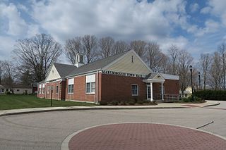
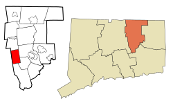
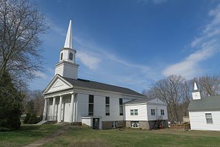
Marlborough is a town in Hartford County, Connecticut, United States. It contains the census-designated place (CDP) of Terramuggus. The town is part of the Capitol Planning Region. The town's population was 6,133 at the 2020 census. Marlborough is a suburban and rural community. The local high school is RHAM High School. In 2013, Marlborough ranked third in Connecticut Magazine's biannual ranking of Connecticut small towns. Educationally, RHAM High School, which serves Marlborough, Hebron, and Andover students, is one of the top-ranked regional high schools in the state on the SAT in 2017, and 11th highest-performing school in the state on the test. The town is home to Elmer Theines-Mary Hall elementary school which serves Pre-K through 6th grade. The school scores above state average on standardized testing and student progress.

<span class="mw-page-title-main">Woodbridge, Connecticut</span> Town in Connecticut, United States

Woodbridge is a town in New Haven County, Connecticut, United States. The town is part of the South Central Connecticut Planning Region. The population was 9,087 at the 2020 census. The town center is listed on the National Register of Historic Places as Woodbridge Green Historic District. Woodbridge is part of the Amity Regional School District #5, rated the #1 school district in New Haven County and the 10th best school district in CT by Niche in 2021. As of 2019 Woodbridge has the 7th highest median household income in CT.

<span class="mw-page-title-main">Andover, Connecticut</span> Town in Connecticut, United States

Andover is a rural town in the Capitol Planning Region, Connecticut, United States, roughly 10 miles east of Hartford. The population was 3,151 at the 2020 census.

<span class="mw-page-title-main">Columbia, Connecticut</span> Town in Connecticut, United States

Columbia is a town in the Capitol Planning Region, Connecticut, United States. The population was 5,272 at the 2020 census. Originally a part of Lebanon, known as the North Society or Lebanon's Crank, Columbia was incorporated in May 1804. The town was named for patriotic reasons after the national symbol "Columbia". Columbia offers pre-kindergarten through eighth grade education in town at Horace W. Porter School, while high school students have a choice of attending four nearby high schools; E. O. Smith High School, Bolton High School (Connecticut), Coventry High School, and Windham Technical High School, part of the Connecticut Technical High School System).

<span class="mw-page-title-main">Coventry, Connecticut</span> Town in Connecticut, United States

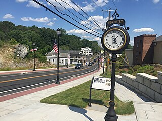
Coventry is a town in Tolland County and in the Capitol Planning Region, Connecticut, United States. The population was 12,235 at the 2020 census. The birthplace of Captain Nathan Hale, Coventry is home to the Nathan Hale Homestead, which is now a museum open to the public.

<span class="mw-page-title-main">Hebron, Connecticut</span> Town in Connecticut, United States

Hebron is a town in Tolland County, Connecticut, United States. The town is part of the Capitol Planning Region. The population was 9,098 at the 2020 census. Hebron was incorporated May 26, 1708. In 2010, Hebron was rated #6 in Top Towns in Connecticut with population between 6,500 and 10,000, according to Connecticut Magazine.

<span class="mw-page-title-main">Tolland, Connecticut</span> Town in Connecticut, United States

Tolland is a suburban town in Tolland County, Connecticut, United States. The town is part of the Capitol Planning Region. The population was 14,563 at the 2020 census.

<span class="mw-page-title-main">Union, Connecticut</span> Town in Connecticut, United States

Union is a town located in the northeastern part of Tolland County, Connecticut, United States and is part of the Northeastern Connecticut Planning Region and Last Green Valley National Heritage Corridor. The population was 785 at the 2020 census, making it the least populous town and municipality in Connecticut. Union includes the village of Mashapaug located in the Eastern Uplands at the Massachusetts state line. Union is located 33 miles northeast of the state capital, Hartford and 67 mi (108 km) southwest of Boston, as well as 153 mi (246 km) northeast of New York City.

<span class="mw-page-title-main">Vernon, Connecticut</span> Town in Connecticut, United States

Vernon is the most populous town in Tolland County, Connecticut, United States. The town is part of the Capitol Planning Region. The population was 30,215 at the 2020 census. Vernon contains the smaller villages of Talcottville and Dobsonville. Vernon contains the former City of Rockville.

<span class="mw-page-title-main">Willington, Connecticut</span> Town in Connecticut, United States

Willington is a town in Tolland County, Connecticut, United States. The town is part of the Capitol Planning Region. The population was 5,566 at the 2020 census.

<span class="mw-page-title-main">Tolland, Massachusetts</span> Town in Massachusetts, United States

Tolland is a town in Hampden County, Massachusetts, United States. It is part of the Springfield, Massachusetts Metropolitan Statistical Area. The population was 471 at the 2020 census, making it the smallest town in Hampden County by population.

<span class="mw-page-title-main">East Hartford, Connecticut</span> Town in Connecticut, United States

East Hartford is a town in the Capitol Planning Region, Connecticut, United States. The population was 51,045 at the 2020 census. The town is located on the east bank of the Connecticut River, directly across from Hartford. It is home to aerospace manufacturer Pratt & Whitney. It is also home to Pratt & Whitney Stadium at Rentschler Field, a stadium used mainly for soccer and football with a capacity of 40,000 people.

<span class="mw-page-title-main">Windsor Locks, Connecticut</span> Town in Connecticut, United States

Windsor Locks is a town in Hartford County, Connecticut, United States. The town is part of the Capitol Planning Region. As of the 2020 census, its population was 12,613. It is the site of Bradley International Airport, which serves the Greater Hartford-Springfield region and occupies approximately a third of the town. Windsor Locks is also the site of the New England Air Museum.

References

  1. "Geographic Identifiers: 2010 Census Summary File 1 (G001): Bolton town, Tolland County, Connecticut". American Factfinder. U.S. Census Bureau. Archived from the original on February 13, 2020. Retrieved March 14, 2018.
  2. "Census - Geography Profile: Bolton town, Tolland County, Connecticut". United States Census Bureau . Retrieved November 26, 2021.
  3. The Connecticut Magazine: An Illustrated Monthly. Connecticut Magazine Company. 1903. p. 331. Archived from the original on April 27, 2018.
  4. George M. Marsden (July 11, 2004). Jonathan Edwards: A Life. Yale University Press. p. 95. ISBN   978-0-300-10596-4 . Retrieved October 17, 2010.
  5. Town Resident
  6. "Connecticut I-384". www.kurumi.com. Retrieved February 27, 2023.
  7. "From Hartford to Providence". www.kurumi.com. Retrieved February 27, 2023.
  8. "Climate Statistics for Bolton, CT". Archived from the original on January 6, 2014. Retrieved January 5, 2014.
  9. "Bolton High School in Bolton, CT | US News Best High Schools". Archived from the original on March 30, 2017. Retrieved August 24, 2017.
  10. "Archived copy" (PDF). Archived from the original (PDF) on August 31, 2013. Retrieved August 17, 2013.{{cite web}}: CS1 maint: archived copy as title (link)
  11. "Census of Population and Housing". Census.gov. Retrieved June 4, 2015.
  12. 1 2 3 4 "Profile of General Population and Housing Characteristics: 2010 Census Summary File 1 (G001): Bolton town, Tolland County, Connecticut". American Factfinder. U.S. Census Bureau. Archived from the original on February 13, 2020. Retrieved March 14, 2018.
  13. "Selected Economic Characteristics: 2012-2016 American Community Survey 5-Year Estimates (DP03): Bolton town, Tolland County, Connecticut". American Factfinder. U.S. Census Bureau. Archived from the original on February 13, 2020. Retrieved March 14, 2018.
  14. "Registration and Party Enrollment Statistics as of October 29, 2019" (PDF). Connecticut Secretary of State. Retrieved February 17, 2020.
  15. "General Election Statements of Vote, 1922 – Current". CT Secretary of State. Retrieved July 10, 2020.
  16. "Election Night Reporting". CT Secretary of State. Retrieved December 16, 2020.
  17. "Aloysius J. Ahearn obituary". Hartford Courant . May 5, 2020. Archived from the original on May 25, 2020. Retrieved May 25, 2020.