Scotland, Connecticut

Last updated
Scotland, Connecticut
Town of Scotland
ScotlandCT Center.jpg
The center of Scotland
ScotlandCTseal.png
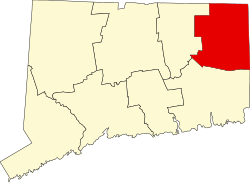
Windham County Connecticut incorporated and unincorporated areas Scotland highlighted.svg
Scotland, Connecticut
Coordinates: 41°42′01″N72°04′59″W / 41.70028°N 72.08306°W / 41.70028; -72.08306 Coordinates: 41°42′01″N72°04′59″W / 41.70028°N 72.08306°W / 41.70028; -72.08306
CountryFlag of the United States.svg  United States
U.S. state Flag of Connecticut.svg  Connecticut
County Windham
Region Northeastern CT
Incorporated1857
Government
  Type Selectman-town meeting
   First selectman Gary Greenberg (D)
  SelectmanWendy Sears (R)
  SelectmanRobert Keator (R)
Area
  Total18.7 sq mi (48.4 km2)
  Land18.6 sq mi (48.2 km2)
  Water0.0 sq mi (0.1 km2)
Elevation
272 ft (83 m)
Population
 (2020)
  Total1,576
  Density84/sq mi (33/km2)
Time zone UTC-5 (Eastern)
  Summer (DST) UTC-4 (Eastern)
ZIP code
06264
Area code(s) 860/959
FIPS code 09-67400
GNIS feature ID0213501
Website www.scotlandct.org

Scotland is a town in Windham County, Connecticut. The town is part of the Northeastern Connecticut Planning Region. As of the 2020 census, the town population was 1,576. Scotland is a predominantly rural town with agriculture as the principal industry. [1] Scotland is the least populated town in Windham County.

Contents

Geography

According to the U.S. Census Bureau, the town has a total area of 18.7 square miles (48.3 km2), of which, 18.6 square miles (48.2 km2) of it is land and 0.1 square miles (0.1 km2) of it (0.27%) is water. It was incorporated in 1857.

History

In 1700, Isaac Magoon purchased 1,950 acres (7.9 km2) of land from then Windham and thus began Scotland's History. He named the town Scotland as a way of commemorating his ancestral home. Scotland was incorporated in May 1857. [2]

Government

The town still maintains the town meeting as its form of government with a board of selectmen. The town also has eight boards & commissions, including Inlands & Wetlands, Planning & Zoning and Board of Education. [3]

Education

Scotland Elementary School, located on Brook Road, serves grades Pre-K–6 for the town, which is part of Regional School District 11.

Attractions

Scotland is home to the D'Elia Antique Tool Museum, a museum built in 2005 and housed in the same building as the Scotland Public Library. It is the home of over 1200 antique woodworking planes dating back to the mid-18th century. A second attraction is the Samuel Huntington Birthplace, birthplace of Samuel Huntington, a Founding Father, located on Huntington Road or CT Route 14.

Transportation

CT Route 14 passes east–west through the town. Route 97 goes north–south through the town. The Providence and Worcester Railroad runs through the south-western part of the town, but doesn't stop.

On the National Register of Historic Places

Demographics

Historical population
CensusPop.Note
1860 720
1870 643−10.7%
1880 590−8.2%
1890 506−14.2%
1900 471−6.9%
1910 4761.1%
1920 391−17.9%
1930 4022.8%
1940 47818.9%
1950 5137.3%
1960 68433.3%
1970 1,02249.4%
1980 1,0724.9%
1990 1,21513.3%
2000 1,55628.1%
2010 1,72610.9%
2020 1,576−8.7%
U.S. Decennial Census [4]

At the 2020 census there were 1,576 people, 553 households, and 425 families living in the town. The population density was 83.6 inhabitants per square mile (32.3/km2). There were 577 housing units at an average density of 31.0 per square mile (12.0/km2). The racial makeup of the town was 97.69% White, 0.45% African American, 0.06% Native American, 0.51% Asian, 0.19% Pacific Islander, 0.51% from other races, and 0.58% from two or more races. Hispanic or Latino of any race were 2.31%. [5]

Of the 553 households 37.4% had children under the age of 18 living with them, 67.5% were married couples living together, 6.9% had a female householder with no husband present, and 23.0% were non-families. 15.7% of households were one person and 4.9% were one person aged 65 or older. The average household size was 2.81 and the average family size was 3.16.

The age distribution was 28.2% under the age of 18, 5.9% from 18 to 24, 31.7% from 25 to 44, 25.3% from 45 to 64, and 8.9% 65 or older. The median age was 37 years. For every 100 females, there were 100.8 males. For every 100 females age 18 and over, there were 98.0 males.

The median household income was $56,848 and the median family income was $60,147. Males had a median income of $40,871 versus $29,830 for females. The per capita income for the town was $22,573. About 4.0% of families and 4.7% of the population were below the poverty line, including 4.7% of those under age 18 and 10.9% of those age 65 or over.

Notable people

Samuel Huntington depicted in a 1783 portrait by Charles Willson Peale Samuel Huntington - Charles Willson Peale.jpg
Samuel Huntington depicted in a 1783 portrait by Charles Willson Peale

Related Research Articles

<span class="mw-page-title-main">Windham County, Connecticut</span> County in Connecticut, United States

Windham County is a county located in the northeastern corner of the U.S. state of Connecticut. As of the 2020 census, the population was 116,418, making it the least populous county in Connecticut. It forms the core of the region known as the Quiet Corner. Windham County is included in the Worcester, MA-CT Metropolitan Statistical Area, which is also included in the Boston-Worcester-Providence, MA-RI-NH-CT Combined Statistical Area. The entire county is within the Quinebaug and Shetucket Rivers Valley National Heritage Corridor, as designated by the National Park Service.

<span class="mw-page-title-main">Roxbury, Connecticut</span> Town in Connecticut, United States

Roxbury is a town in Litchfield County, Connecticut, United States. The population was 2,260 at the 2020 census. The town is located 65 miles (105 km) northeast of New York City, and is part of the Northwest Hills Planning Region.

<span class="mw-page-title-main">Warren, Connecticut</span> Town in Connecticut, United States

Warren is a town in Litchfield County, Connecticut, United States. The population was 1,351 at the 2020 census. The town is part of the Northwest Hills Planning Region. The town was named for Revolutionary War General Joseph Warren.

<span class="mw-page-title-main">Woodbury, Connecticut</span> Town in Connecticut, United States

Woodbury is a town in Litchfield County, Connecticut, United States. The town is part of the Naugatuck Valley Planning Region. The population was 9,723 at the 2020 census. The town center, comprising the adjacent villages of Woodbury and North Woodbury, is designated by the U.S. Census Bureau as the Woodbury Center census-designated place (CDP). Woodbury was founded in 1673.

<span class="mw-page-title-main">Andover, Connecticut</span> Town in Connecticut, United States

Andover is a rural town in the Capitol Planning Region, Connecticut, United States, roughly 10 miles West of Hartford. The population was 3,151 at the 2020 census. Andover is home to Andover Elementary School for grades K–6 while grades 7–12 go to R.H.A.M. middle and high schools. Andover elementary scores above average on standardized testing and student development as well as having a notably low student to teacher ratio of 8:1.

<span class="mw-page-title-main">Columbia, Connecticut</span> Town in Connecticut, United States

Columbia is a town in the Capitol Planning Region, Connecticut, United States. The population was 5,272 at the 2020 census. Originally a part of Lebanon, known as the North Society or Lebanon's Crank, Columbia was incorporated in May 1804. The town was named for patriotic reasons after the national symbol "Columbia". Columbia offers pre-kindergarten through 8th grade education in town at Horace W. Porter School, while high school students have a choice of attending four nearby high schools; E.O Smith High School, Bolton High School (Connecticut), Coventry High School, and Windham Technical High School, part of the Connecticut Technical High School System).

<span class="mw-page-title-main">Hebron, Connecticut</span> Town in Connecticut, United States

Hebron is a town in Tolland County, Connecticut, United States. The population was 9,098 at the 2020 census. Hebron was incorporated May 26, 1708. In 2010, Hebron was rated #6 in Top Towns in Connecticut with population between 6,500 and 10,000, according to Connecticut Magazine.

<span class="mw-page-title-main">Somers, Connecticut</span> Town in Connecticut, United States

Somers is a town in Tolland County, Connecticut. The population was 10,255 at the 2020 census. The town center is listed by the U.S. Census Bureau as a census-designated place (CDP). In 2007, Money Magazine listed Somers 53rd on its "100 Best Places to Live", based on "economic opportunity, good schools, safe streets, things to do and a real sense of community."

<span class="mw-page-title-main">Willington, Connecticut</span> Town in Connecticut, United States

Willington is a town in Tolland County, Connecticut, United States. The population was 5,566 at the 2020 census.

<span class="mw-page-title-main">Brooklyn, Connecticut</span> Town in Connecticut, United States

Brooklyn is a town in Windham County, Connecticut, United States. The town is part of the Northeastern Connecticut Planning Region. The population was 8,450 at the 2020 census. The town center village is listed by the U.S. Census Bureau as a census-designated place. The district of East Brooklyn is listed as a separate census-designated place.

<span class="mw-page-title-main">Canterbury, Connecticut</span> Town in Connecticut, United States

Canterbury is a town in Windham County, Connecticut, United States. The town is part of the Northeastern Connecticut Planning Region. The population was 5,045 at the 2020 census.

<span class="mw-page-title-main">Chaplin, Connecticut</span> Town in Connecticut, United States

Chaplin is a town in Windham County, Connecticut, United States. The town is part of the Northeastern Connecticut Planning Region. The town was named for Deacon Benjamin Chaplin, an early settler. The population was 2,151 at the 2020 census.

<span class="mw-page-title-main">Eastford, Connecticut</span> Town in Connecticut, United States

Eastford is a town in Windham County, Connecticut, United States. The town is part of the Northeastern Connecticut Planning Region. The population was 1,649 at the 2020 census.

<span class="mw-page-title-main">Hampton, Connecticut</span> Town in Connecticut, United States

Hampton is a town in Windham County, Connecticut, United States. The town is part of the Northeastern Connecticut Planning Region. The population was 1,728 at the 2020 census.

<span class="mw-page-title-main">Plainfield, Connecticut</span> Town in Connecticut, United States

Plainfield is a town in Windham County, Connecticut, United States. The town is part of the Northeastern Connecticut Planning Region. The population was 14,973 at the 2020 census. The town comprises four villages: Plainfield, Moosup, Wauregan, and Central Village. Each village has their own respective United States Post Office and fire department. The entire town is serviced by the 860 area code.

<span class="mw-page-title-main">Pomfret, Connecticut</span> Town in Connecticut, United States

Pomfret is a town located in Windham County, Connecticut with a population of 4,266 according to the 2020 United States Census. The town is part of the Northeastern Connecticut Planning Region. The town was incorporated in 1713 and was named after Pontefract in West Yorkshire, England. The land on which Pomfret stands today was purchased from Native Americans in 1686 in a deal known as the "Mashmuket Purchase" or "Mashamoquet Purchase".

<span class="mw-page-title-main">Windham, Connecticut</span> Town in Connecticut, United States

Windham is a town in Windham County, Connecticut, United States. It contains the former city of Willimantic as well as the boroughs of Windham Center, North Windham, and South Windham. Willimantic, an incorporated city since 1893, was consolidated with the town in 1983. The population was 24,428 at the 2020 census.

<span class="mw-page-title-main">Huntington Township, Luzerne County, Pennsylvania</span> Township in Pennsylvania, United States

Huntington Township is an American township which is in Luzerne County, Pennsylvania. The population was 2,052 at the time of the 2020 census.

<span class="mw-page-title-main">Ridgefield (CDP), Connecticut</span> Census-designated place in Connecticut, United States

Ridgefield is a census-designated place (CDP) in Fairfield County, Connecticut, United States. It consists of the primary central village in the town of Ridgefield and surrounding residential areas. As of the 2010 census, the population of the CDP was 7,645, out of 24,638 in the entire town.

<span class="mw-page-title-main">Canaan, Connecticut</span> Town in Connecticut, United States

Canaan is a town in Litchfield County, Connecticut, United States. The population was 1,080 at the 2020 census, down from 1,234 at the 2010 census. The town is part of the Northwest Hills Planning Region. The town of Canaan is often referred to locally by the name of its principal settlement, Falls Village.

References

  1. "Town of Scotland, Connecticut | Welcome to Scotland, CT". www.scotlandct.org. Retrieved 2018-10-06.
  2. About Scotland, CT, ScotlandCT.org. Retrieved 2014-03-02.
  3. "Town of Scotland, CT - Boards and Commissions". www.scotlandct.org. Archived from the original on 2008-02-14.
  4. "2020 Decennial Census". Census.gov. Retrieved December 12, 2021.
  5. "U.S. Census website". United States Census Bureau . Retrieved 2008-01-31.