Mechanicsville, Connecticut

Last updated

Mechanicsville, Connecticut
Mechanicsville Park, Mechanicsville CT.jpg
Mechanicsville Park
USA Connecticut location map.svg
Red pog.svg
Mechanicsville
Usa edcp location map.svg
Red pog.svg
Mechanicsville
Coordinates: 41°56′28″N71°53′37″W / 41.94111°N 71.89361°W / 41.94111; -71.89361
Country Flag of the United States (23px).png  United States
State Connecticut
County Windham
Town Thompson
Area
[1]
  Total2.16 km2 (0.83 sq mi)
  Land2.16 km2 (0.83 sq mi)
  Water0.0 km2 (0.0 sq mi)
Elevation
[2]
90 m (310 ft)
Time zone UTC-5 (Eastern (EST))
  Summer (DST) UTC-4 (EDT)
ZIP Codes
Area code(s) 860/959
FIPS code 09-46240
GNIS feature ID2805993 [2]

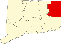
Mechanicsville is an unincorporated community and census-designated place (CDP) in the southern part of the town of Thompson in Windham County, Connecticut, United States. It is bordered to the north by North Grosvenordale and to the south by Putnam. Connecticut Route 12 (Riverside Drive) runs the length of the community, along the east side of the French River.

Mechanicsville was first listed as a CDP prior to the 2020 census. [2]

A portion of the Air Line State Park Trail passes through Mechanicsville, along with the Providence and Worcester Railroad.

Related Research Articles

<span class="mw-page-title-main">Old Saybrook Center, Connecticut</span> Census-designated place in Connecticut, United States of America

Old Saybrook Center is the primary village and a census-designated place (CDP) in the town of Old Saybrook, Middlesex County, Connecticut, United States. The population was 2,278 at the 2020 census, out of 10,481 in the entire town of Old Saybrook. The CDP includes the traditional town center and the peninsula known as Saybrook Point.

<span class="mw-page-title-main">Charlotte Hall, Maryland</span> CDP in Maryland, United States

Charlotte Hall is a census-designated place (CDP) in Charles and St. Mary's counties, Maryland, United States. The population was 1,420 at the 2010 census. The Maryland Veterans Home for disabled veterans, is located on the site of the former Charlotte Hall Military Academy. The Academy site was declared the Charlotte Hall Historic District, and listed on the National Register of Historic Places in 1975. Since 1940, a sizable Amish farming community has existed nearby, along with a farmers' market and large flea market complex on Maryland Route 5, which is also the site of numerous strip-mall businesses continuing into the adjacent community of Mechanicsville. A U.S. Veterans Affairs clinic is across the highway from the Veterans Home.

<span class="mw-page-title-main">Mechanicsville, Virginia</span> Census-designated place in Virginia, United States

Mechanicsville is an unincorporated community and census-designated place (CDP) in Hanover County, Virginia, United States. The population was 39,482 during the 2020 census, up from 36,348 in the 2010 census.

<span class="mw-page-title-main">Portland (CDP), Connecticut</span> Census-designated place in Connecticut, United States

Portland is a census-designated place (CDP) comprising the primary village and adjacent residential land in the town of Portland, Middlesex County, Connecticut, United States. It is in the southwest part of the town, bordered to the west and south by the Connecticut River, which forms the border with Cromwell to the west and Middletown to the south. The Portland CDP extends north along Main Street to its junction with Gospel Lane at Fogelmarks Corners, and the eastern extent of the CDP is at Rose Hill Road and Collins Hill Road. The CDP includes the neighborhood of Gildersleeve in the north.

<span class="mw-page-title-main">Mechanicsville, Maryland</span> Census-designated place in Maryland, United States

Mechanicsville is an unincorporated community and census-designated place in St. Mary's County, Maryland, United States. It is adjacent to the community of Charlotte Hall, which is known for its agriculture, Amish population, large farmers' market/flea market and the Maryland Veterans Home. Mechanicsville has many small businesses and restaurants along Maryland Route 5 and Maryland Route 235. The community is served by the St. Mary's County Public Schools, including Chopticon High School. At the 2010 census, Mechanicsville had a population of 1,528.

<span class="mw-page-title-main">Noroton Heights, Connecticut</span> Census-designated place in Connecticut, United States

Noroton Heights is a village and census-designated place (CDP) in the town of Darien, Connecticut, United States. The community is located on Connecticut's Gold Coast. Located close to Long Island Sound, in the Connecticut panhandle, it is approximately 35 miles (56 km) northeast of Midtown Manhattan and immediately to the east of Stamford. As of the 2020 census, the CDP has a population of 3,116.

Saugatuck is a census-designated place (CDP) in the town of Westport, Fairfield County, Connecticut, United States. It is in the southwest part of the town, on both sides of the Saugatuck River, extending south to where it enters Long Island Sound. North of Interstate 95, it occupies just the west side of the Saugatuck and continues north as far as U.S. Route 1. It is bordered to the north by Westport Village and to the west by the city of Norwalk. The CDP includes the communities of Owenoke and Saugatuck Shores, as well as the Metro-North Railroad Westport station.

<span class="mw-page-title-main">Wallingford Center, Connecticut</span> Census-designated place in Connecticut, United States

Wallingford Center is a census-designated place (CDP) comprising the primary community in the town of Wallingford, New Haven County, Connecticut, United States. It is in the central and southern parts of the town, bordered to the west by the Wilbur Cross Parkway, to the east by Interstate 91, and to the south by the town of North Haven. To the north the CDP extends to New Rock Hill Road, Durham Road, Christian Street, North Elm Street, Maplewood Avenue, and up North Main Street as far as Yale Avenue, where it crosses the Wilbur Cross Parkway. U.S. Route 5 is the main north–south road through the community. To the north is the neighborhood of Yalesville.

<span class="mw-page-title-main">Westbrook Center, Connecticut</span> Census-designated place in Connecticut, United States

Westbrook Center is a census-designated place (CDP) comprising the primary village and adjacent residential land in the town of Westbrook, Middlesex County, Connecticut, United States. It is in the southern part of the town, along U.S. Route 1 and bordered to the south by Long Island Sound. To the east it is bordered by the town of Old Saybrook, and the west and northwest border of the CDP is the Patchogue River. As of the 2020 census, the CDP had a population of 2,220, out of 6,769 in the entire town of Westbrook.

Redding Center is a census-designated place (CDP) in the town of Redding, Fairfield County, Connecticut, United States, comprising the central village in the town. Connecticut Route 107 passes through the community, leading north toward Bethel and southwest toward Georgetown. The Redding Center Historic District is at the center of the CDP, around the intersections of Cross Highway, Sanfordtown Road, Lonetown Road, and Hill Road.

<span class="mw-page-title-main">Wilton Center, Connecticut</span> Census-designated place in Connecticut, United States

Wilton Center is a neighborhood/section and census-designated place (CDP) in the town of Wilton in Fairfield County, Connecticut, United States. As of the 2010 census it had a population of 732. The CDP partially overlaps the Wilton Center Historic District.

Noroton is a census-designated place (CDP) in the town of Darien, Fairfield County, Connecticut, United States. It occupies the southwest part of Darien, from the Metro-North Railroad in the north to Long Island Sound in the south. The southern half of the community occupies Noroton Neck, between Holly Pond to the west and the Goodwives River to the east. It is bordered to the west by the city of Stamford and to the east by the Tokeneke neighborhood of Darien. To the north is Noroton Heights.

Murray is a census-designated place (CDP) in the town of Fairfield, Fairfield County, Connecticut, United States. It is in the northern part of Fairfield, with Burr Street running north–south through the center of the CDP. The Merritt Parkway crosses the CDP from east to west, with access from Exit 44 at the eastern edge of the community.

Oronoque is a census-designated place (CDP) in the town of Stratford, Fairfield County, Connecticut, United States. It is in the northern part of the town, bordered to the north by the city of Shelton, to the east by the Housatonic River, and to the south by the Merritt Parkway. Connecticut Route 110 runs north–south through the community. The administrative offices of Sikorsky Aircraft are in the eastern part of the CDP, between Route 110 and the Housatonic River.

South Wilton is a census-designated place (CDP) in the town of Wilton, Fairfield County, Connecticut, United States. It is in the southern part of the town along U.S. Route 7, in the valley of the Norwalk River. It is bordered to the north by Wilton Center and to the south by the city of Norwalk.

Weston is a census-designated place (CDP) in the town of Weston, Fairfield County, Connecticut, United States. It comprises the center of town government and surrounding residential areas. The area was known as "Norfield" from 1795 to 1920, and the Norfield Historic District, which occupies the center of the CDP, around the intersection of Norfield Road and Weston Road, preserves the older name.

<span class="mw-page-title-main">Candlewood Orchards, Connecticut</span> Census-designated place in Connecticut, United States

Candlewood Orchards is a private residential community and census-designated place (CDP) in the town of Brookfield, Fairfield County, Connecticut, United States. It is in the northwest part of the town, on the east shore of Candlewood Lake. It is bordered to the north by Candlewood Shores and to the west and south by the town of New Fairfield.

<span class="mw-page-title-main">Candlewood Shores, Connecticut</span> Census-designated place in Connecticut, United States

Candlewood Shores is a private residential community and census-designated place (CDP) in the town of Brookfield, Fairfield County, Connecticut, United States. It is in the northwest part of the town, on the east shore of Candlewood Lake. It is bordered to the south by Candlewood Orchrads, to the north by Candlewood Lake Club, and to the west by the town of New Fairfield.

<span class="mw-page-title-main">Candlewood Lake Club, Connecticut</span> Census-designated place in Connecticut, United States

Candlewood Lake Club is a private residential community and census-designated place (CDP) in the town of Brookfield, Fairfield County, and in the town of New Milford, Litchfield County, in the U.S. state of Connecticut. It is in the northwest corner of Brookfield and the southwest corner of New Milford, on the east shore of Candlewood Lake. It is bordered to the south by Candlewood Shores, to the north by Chimney Point, and to the west by the town of New Fairfield.

Sherman is a census-designated place (CDP) comprising the central community in the town of Sherman, Fairfield County, Connecticut, United States. It is in the central part of the town, at the north end of Candlewood Lake. The Sherman Historic District covers 85 acres (34 ha) in the northern part of the CDP, at the intersection of Connecticut Routes 37 and 39, containing many of the oldest buildings in the town.

References

  1. "2020 U.S. Gazetteer Files – Connecticut". United States Census Bureau. Retrieved April 16, 2021.
  2. 1 2 3 "Mechanicsville Census Designated Place". Geographic Names Information System . United States Geological Survey, United States Department of the Interior.