
U.S. Route 5 (US 5) is a north–south United States Numbered Highway running through the New England states of Connecticut, Massachusetts, and Vermont. Significant cities along the route include New Haven, Connecticut; Hartford, Connecticut; and Springfield, Massachusetts. From Hartford northward to St. Johnsbury, Vermont, the road closely follows the route of the Connecticut River.

Interstate 395 (I-395) is an auxiliary Interstate Highway in the U.S. states of Connecticut and Massachusetts; it is maintained by the Connecticut Department of Transportation (CTDOT) and the Massachusetts Department of Transportation (MassDOT). Spanning nearly 67 miles (108 km) on a south–north axis, it is the only spur route of I-95 in Connecticut. The 36-mile (58 km) section between its splits from I-95 in East Lyme and SR 695 in Plainfield is a component highway of the Connecticut Turnpike. Within that state, the highway is named the American Ex-Prisoner of War Memorial Highway from Plainfield to Thompson.
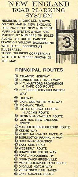
The New England road marking system was a regional system of marked numbered routes in the six-state region of New England in the United States. The routes were marked by a yellow rectangular sign with black numbers and border. Many signs were painted on telephone poles. The routes were approved by the highway departments of the six New England states in April 1922.

New Hampshire Route 10 is a 122.25-mile-long (196.74 km) north–south state highway in western New Hampshire, United States. Its southern terminus is in Winchester at the Massachusetts state line, where it continues south as Massachusetts Route 10. Administratively, the northern terminus is at a junction with U.S. Route 302 in Haverhill.

New Hampshire Route 12 is a 62.773-mile (101.023 km) long north–south state highway in southwestern New Hampshire. Its southern terminus is at the Massachusetts state line in Fitzwilliam, where it continues south as Massachusetts Route 12. Its northern terminus is at the Vermont state line in Claremont, where it continues north as Vermont Route 12. Most of the northern part of NH 12 runs along the Connecticut River.

Route 2 is a 58.03-mile (93.39 km) state highway in Hartford and New London counties in Connecticut. It is a primary state route, with a freeway section connecting Hartford to Norwich and following surface roads to Stonington. The entire freeway section of Route 2 west of Route 169 is also known as the Veterans of Foreign Wars Memorial Highway Though it is labelled an east-west highway, it follows a northwest-southeast route, with large sections of the highway running north-south throughout its duration.

Interstate 95 (I-95) is the main north–south Interstate Highway on the East Coast of the United States, running in a general east–west compass direction for 111.57 miles (179.55 km) in Connecticut, from the New York state line to the Rhode Island state line. I-95 from Greenwich to East Lyme is part of the Connecticut Turnpike, during which it passes through the major cities of Stamford, Bridgeport, and New Haven. After leaving the turnpike in East Lyme, I-95 is known as the Jewish War Veterans Memorial Highway and passes through New London, Groton, and Mystic, before exiting the state through North Stonington at the Rhode Island border and goes on.

Massachusetts Route 10 is a 60.69-mile-long (97.67 km) north–south state highway that runs from the Connecticut state line at Southwick to the New Hampshire state line at Northfield. Originally part of New England Route 10 from 1922 to 1927, it continues to the south as Connecticut Route 10, and to the north as New Hampshire Route 10.

Route 32 is a 54.88-mile (88.32 km) primary north–south state highway in the U.S. state of Connecticut, beginning in New London and continuing via Willimantic to the Massachusetts state line, where it continues as Massachusetts Route 32.
Interstate 95 (I-95) is the main north–south Interstate Highway on the East Coast of the United States, running generally southwest–northeast through the US state of Rhode Island. It runs from the border with Connecticut near Westerly, through Warwick and Providence, and to the Massachusetts state line in Pawtucket. It has two auxiliary routes, both of which enter Massachusetts—I-195, a spur from Providence east to Cape Cod, and I-295, a western bypass of the Providence metropolitan area.

Route 169 is a 47.36-mile-long (76.22 km) state highway in the U.S. states of Connecticut and Massachusetts. It begins in the city of Norwich, Connecticut, and runs 38 miles (61 km) through Northeastern Connecticut, continuing across the state line into Southbridge, Massachusetts. The route ends in Charlton after another nine miles (14 km). A portion of the route in the town center of Pomfret is on the National Register of Historic Places as Pomfret Street Historic District, and 32.10 miles (51.66 km) of the road is designated as the Connecticut State Route 169 National Scenic Byway.

Massachusetts Route 32 is a state highway in the U.S. state of Massachusetts. The highway runs 60.66 miles (97.62 km) from the Connecticut state line north to the New Hampshire state line, where it continues as NH 32. Route 32 connects several towns on the eastern edge of Western Massachusetts. The highway serves Palmer in eastern Hampden County, Ware in eastern Hampshire County, and Barre and Athol in northwestern Worcester County. Route 32 intersects major east–west routes including U.S. Route 20 and the Massachusetts Turnpike in Palmer, Route 9 in Ware, and US 202 and Route 2 in Athol. The highway has an alternate route, Route 32A, through Hardwick and Petersham.

Route 349 begins as a limited-access spur from I-95 leading to the city of Groton. It has full interchanges with I-95 and US 1. The limited-access portion is 1.9 miles (3.1 km) long and is known as the Clarence B. Sharp Highway.

Route 131 is a 13.55-mile-long (21.81 km) state highway in the U.S. states of Massachusetts and Connecticut. It serves the southwestern portion of the Worcester metropolitan area. It begins at Route 12 in the North Grosvenordale section of the town of Thompson in Connecticut and ends at U.S. Route 20 in the center of Sturbridge in Massachusetts.

Route 215 is a state highway in southeastern Connecticut, running entirely within the town of Groton in a loop off US 1 through the Noank and West Mystic sections of Groton and also serves the Groton Long Point community.

Route 193 is a 9.40-mile-long (15.13 km) state highway in the U.S. states of Connecticut and Massachusetts. The route travels between the town centers of Thompson, Connecticut and Webster, Massachusetts. The road closely parallels Interstate 395 throughout its entire length. It is signed North-South, with the exception of one East-West Sign at the South end.

Route 184 is a state highway in southeastern Connecticut, running from Groton to North Stonington.

Route 197 is a 14.17-mile-long (22.80 km) state highway in northeastern Connecticut and southern Massachusetts, running from Union, Connecticut, to Dudley, Massachusetts. The Connecticut section is signed as an east–west route, while the Massachusetts section is signed north–south.
U.S. Route 5 (US 5) is a part of the United States Numbered Highway System that runs from New Haven, Connecticut, to the Canada–United States border at Derby Line, Vermont. In Vermont, the road runs south–north from the Massachusetts state line near Guilford to the international border. The 192.317 miles (309.504 km) that lie in Vermont are maintained by the Vermont Agency of Transportation (VTrans) and run largely parallel to Interstate 91 (I-91). US 5 also follows the path of the Connecticut River from the Massachusetts border to St. Johnsbury, where the river turns northeast while US 5 continues north. The highway serves the major towns of Brattleboro, Hartford, and St. Johnsbury, along with the city of Newport near the Canadian border.

U.S. Route 44 (US 44) is an east–west United States Numbered Highway that runs for 237 miles (381 km) through four states in the Northeastern United States. The western terminus is at US 209 and New York State Route 55 (NY 55) in Kerhonkson, New York, a hamlet in the Hudson Valley region. The eastern terminus is at Route 3A in Plymouth, Massachusetts.


