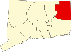
Sterling, Connecticut | |
---|---|
Town of Sterling | |
Coordinates: 41°42′08″N71°48′59″W / 41.70222°N 71.81639°W | |
Country | United States |
U.S. state | Connecticut |
County | Windham |
Region | Northeastern CT |
Incorporated | 1794 |
Government | |
• Type | Selectman-town meeting |
• First selectman | Lincoln A. Cooper (R) |
• Selectman | John F. Firlik (D) |
Area | |
• Total | 27.3 sq mi (70.7 km2) |
• Land | 27.2 sq mi (70.5 km2) |
• Water | 0.1 sq mi (0.2 km2) |
Elevation | 384 ft (117 m) |
Population (2020) | |
• Total | 3,578 |
• Density | 130/sq mi (51/km2) |
Time zone | UTC−5 (Eastern) |
• Summer (DST) | UTC−4 (Eastern) |
ZIP code | 06377, 06373 |
Area code(s) | 860/959 |
FIPS code | 09-73420 |
GNIS feature ID | 0213512 |
Website | www |
Sterling is a town in Windham County, Connecticut, United States. The town is part of the Northeastern Connecticut Planning Region. The population was 3,578 at the 2020 census. [1] The rural town is home to two villages: Oneco (named for Oneco, Sachem of the Mohegans) and Sterling village. Each contains a post office, a church, and a fire station. The town hall and public library are located in Oneco, and the town's one public school is in Sterling village.
The town was named after John Sterling, an early settler. [2] Sterling was incorporated in 1794 following approval of the state Assembly and was carved from northern part of the Town of Voluntown. Le Comte de Rochambeau, Jean Baptiste Donatien de Vimeur, marched through and camped in the town during the American Revolutionary War on his way from landing at Narragansett Bay to join George Washington's forces on the Hudson River in 1781. A cotton mill was first established in Sterling in 1800.[ citation needed ]
Charles Dow, of Dow Jones fame, was born in this community. [3]
According to the United States Census Bureau, the town has a total area of 27.3 square miles (71 km2), of which 27.2 square miles (70 km2) is land and 0.1 square miles (0.26 km2) (0.29%) is water.
Census | Pop. | Note | %± |
---|---|---|---|
1820 | 1,200 | — | |
1850 | 1,025 | — | |
1860 | 1,051 | 2.5% | |
1870 | 1,022 | −2.8% | |
1880 | 957 | −6.4% | |
1890 | 1,051 | 9.8% | |
1900 | 1,209 | 15.0% | |
1910 | 1,283 | 6.1% | |
1920 | 1,266 | −1.3% | |
1930 | 1,233 | −2.6% | |
1940 | 1,251 | 1.5% | |
1950 | 1,298 | 3.8% | |
1960 | 1,397 | 7.6% | |
1970 | 1,853 | 32.6% | |
1980 | 1,791 | −3.3% | |
1990 | 2,357 | 31.6% | |
2000 | 3,099 | 31.5% | |
2010 | 3,830 | 23.6% | |
2020 | 3,578 | −6.6% | |
U.S. Decennial Census [4] |
As of the census [5] of 2000, there were 3,099 people, 1,116 households, and 835 families living in the town. Sterling's population increased 23.6% between 2000 and 2010, making it the third fastest-growing municipality in Connecticut that decade. [6] The population density was 113.8 inhabitants per square mile (43.9/km2). There were 1,193 housing units at an average density of 43.8 per square mile (16.9/km2). The racial makeup of the town was 99.19% White, 0.71% Native American, 0.32% Asian, 0.03% Pacific Islander, 0.16% from other races, and 2.42% from two or more races. Hispanic or Latino people of any race were 1.32% of the population.
There were 1,116 households, out of which 40.2% had children under the age of 18 living with them, 60.7% were married couples living together, 8.4% had a female householder with no husband present, and 25.1% were non-families. 18.1% of all households were made up of individuals, and 5.6% had someone living alone who was 65 years of age or older. The average household size was 2.78 and the average family size was 3.15.
In the town, the population was spread out, with 28.1% under the age of 18, 7.6% from 18 to 24, 36.4% from 25 to 44, 20.4% from 45 to 64, and 7.5% who were 65 years of age or older. The median age was 34 years. For every 100 females, there were 104.6 males. For every 100 females age 18 and over, there were 107.2 males.
The median income for a household in the town was $49,167, and the median income for a family was $52,202. Males had a median income of $39,792 versus $26,167 for females. The per capita income for the town was $19,679. About 3.8% of families and 6.0% of the population were below the poverty line, including 4.3% of those under age 18 and 1.3% of those age 65 or over.
The town has operated the newer Sterling Community School, since the construction and closing of Sterling Memorial School. Plainfield High School in Plainfield is the designated high school of the town. Residents are also given the option to send their children to Killingly High School, Harvard H. Ellis Technical High School, Quinebaug Middle College or ACT High School. [7]
The survival horror video game Faith: The Unholy Trinity is set in Sterling.
New London County is a county in the southeastern corner of Connecticut and comprises the Norwich-New London, Connecticut Metropolitan Statistical Area, which is also included in the Hartford-East Hartford, Connecticut Combined Statistical Area. There is no county government and no county seat, as is the case with all eight of Connecticut's counties; towns are responsible for all local government activities, including fire and rescue, snow removal, and schools.
Windham County is one of the eight historical counties in the U.S. state of Connecticut, located in its northeastern corner. As of the 2020 census, the population was 116,418, making it the least populous county in Connecticut. It forms the core of the region known as the Quiet Corner. Windham County is included in the Worcester, MA-CT Metropolitan Statistical Area, which is also included in the Boston-Worcester-Providence, MA-RI-NH-CT Combined Statistical Area. The entire county is within the Quinebaug and Shetucket Rivers Valley National Heritage Corridor, as designated by the National Park Service.
Voluntown is a town in New London County, Connecticut, United States. The town is part of the Northeastern Connecticut Planning Region. The population was 2,570 at the 2020 census. Voluntown was part of Windham County from 1726 to 1881, after which it became part of New London County.
Andover is a rural town in the Capitol Planning Region, Connecticut, United States, roughly 10 miles east of Hartford. The population was 3,151 at the 2020 census.
Columbia is a town in the Capitol Planning Region, Connecticut, United States. The population was 5,272 at the 2020 census. Originally a part of Lebanon, known as the North Society or Lebanon's Crank, Columbia was incorporated in May 1804. The town was named for patriotic reasons after the national symbol "Columbia". Columbia offers pre-kindergarten through eighth grade education in town at Horace W. Porter School, while high school students have a choice of attending four nearby high schools; E. O. Smith High School, Bolton High School (Connecticut), Coventry High School, and Windham Technical High School, part of the Connecticut Technical High School System).
Willington is a town in Tolland County, Connecticut, United States. The town is part of the Capitol Planning Region. The population was 5,566 at the 2020 census.
Ashford is a town in Windham County, Connecticut, United States. The town is part of the Northeastern Connecticut Planning Region. The population was 4,191 at the 2020 census. It was founded in 1714. Eastford was a part of Ashford until 1847, when the former split off to organize its own town. For this reason North Ashford is located in northeast Eastford.
Canterbury is a town in Windham County, Connecticut, United States. The town is part of the Northeastern Connecticut Planning Region. The population was 5,045 at the 2020 census.
Chaplin is a town in Windham County, Connecticut, United States. The town is part of the Northeastern Connecticut Planning Region. The town was named for Deacon Benjamin Chaplin, an early settler. The population was 2,151 at the 2020 census.
Eastford is a town in Windham County, Connecticut, United States. The town is part of the Northeastern Connecticut Planning Region. The population was 1,649 at the 2020 census.
Hampton is a town in Windham County, Connecticut, United States. The town is part of the Northeastern Connecticut Planning Region. The population was 1,728 at the 2020 census.
Moosup is a village and census-designated place (CDP) in the town of Plainfield, Connecticut, in the United States. The population was 3,231 at the 2010 census.
Plainfield is a town in Windham County, Connecticut, United States. The town is part of the Northeastern Connecticut Planning Region. The population was 14,973 at the 2020 census. The town comprises four villages: Plainfield, Moosup, Wauregan, and Central Village. Each village has their own respective United States Post Office and fire department. The entire town is serviced by the 860 area code.
Plainfield Village is a village and census-designated place (CDP) in the town of Plainfield, Connecticut, United States. The population was 2,557 at the 2010 census. It is located in the southwestern section of town, in the area west of I-395 and south of Route 14. The village is also the core of the Plainfield, CT urban cluster.
Scotland is a town in Windham County, Connecticut, United States. The town is part of the Northeastern Connecticut Planning Region. As of the 2020 census, the town population was 1,576. Scotland is a predominantly rural town, with agriculture being the principal industry. Scotland is the least populous town in Windham County.
Windham is a town in Windham County, Connecticut, United States. It contains the former city of Willimantic as well as the communities of Windham Center, North Windham, and South Windham. Willimantic, an incorporated city since 1893, was consolidated with the town in 1983. The town is part of the Southeastern Connecticut Planning Region. The population was 24,428 at the 2020 census.
North Windham is a census-designated place (CDP) within the town of Windham in Cumberland County, Maine, United States. The population was 4,904 at the 2010 census. It is part of the Portland–South Portland–Biddeford, Maine Metropolitan Statistical Area.
South Woodstock is a village and census-designated place (CDP) in Woodstock, Windham County, Connecticut, United States. The population was 1,291 at the 2010 census.
Plainfield is a town in Otsego County, New York, United States. The population was 915 at the 2010 census.
Vernon is a town in Windham County, Vermont, in the United States. The population was 2,192 at the 2020 census. Vernon is the site of the now-defunct Vermont Yankee, the state of Vermont's only nuclear power plant, which closed in December 2014.