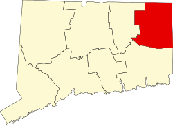
Quasset Lake, Connecticut | |
|---|---|
 Quasset Lake | |
| Coordinates: 41°55′21″N71°59′2″W / 41.92250°N 71.98389°W | |
| Country | |
| State | Connecticut |
| County | Windham |
| Town | Woodstock |
| Area | |
• Total | 1.20 km2 (0.46 sq mi) |
| • Land | 0.84 km2 (0.32 sq mi) |
| • Water | 0.36 km2 (0.14 sq mi) |
| Elevation | 174 m (572 ft) |
| Time zone | UTC-5 (Eastern (EST)) |
| • Summer (DST) | UTC-4 (EDT) |
| ZIP Code | 06281 (Woodstock) |
| Area codes | 860/959 |
| FIPS code | 09-63165 |
| GNIS feature ID | 2805994 [2] |
| Website | quassetlakedistrict |
Quasset Lake is a census-designated place (CDP) in the southeastern part of the town of Woodstock in Windham County, Connecticut, United States, surrounding a lake of the same name. [3] (Federal topographic maps use the name "Wappaquasset Pond". [4] ) It is bordered to the east by South Woodstock.
Quasset Lake was first listed as a CDP prior to the 2020 census. [2]


