Moosup, Connecticut

Last updated

Moosup, Connecticut
Moosup CT.jpg
The center of Moosup
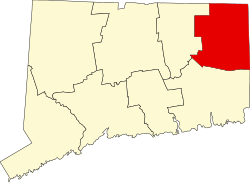
Windham County Connecticut incorporated and unincorporated areas Moosup highlighted.svg
Location in Windham County and the state of Connecticut.
Coordinates: 41°42′46″N71°52′51″W / 41.71278°N 71.88083°W / 41.71278; -71.88083
CountryUnited States
State Connecticut
Town Plainfield
Area
  Total2.3 sq mi (6 km2)
  Land2.2 sq mi (6 km2)
  Water0.04 sq mi (0.1 km2)
Elevation
246 ft (75 m)
Population
 (2010)
  Total3,231
  Density1,400/sq mi (540/km2)
Time zone UTC−5 (Eastern (EST))
  Summer (DST) UTC−4 (EDT)
ZIP code
06354
Area code 860
FIPS code09-49180
GNIS feature ID2377833 [1]

Moosup is a village and census-designated place (CDP) in the town of Plainfield, Connecticut in the United States. The population was 3,231 at the 2010 census.

Contents

History

Moosup is named after sachem Maussup or Moosup (1623-1676) of the Narragansett Indians. The town was established in 1689 a little more than a decade after Maussup's death at the hands of Mohawks. [2] [3]

Geography

Lithograph of Moosup from 1889 by L.R. Burleigh with list of landmarks Moosup, Conn., Uniondale and Almyville (2675179913).jpg
Lithograph of Moosup from 1889 by L.R. Burleigh with list of landmarks

According to the United States Census Bureau, the CDP has a total area of 2.3 square miles (6.0 km2), of which, 2.2 square miles (5.7 km2) of it is land and 0.04 square miles (0.10 km2) of it (0.85%) is water.

Demographics

As of the census [4] of 2000, there were 3,237 people, 1,263 households, and 837 families residing in the CDP. The population density was 1,390.4 inhabitants per square mile (536.8/km2). There were 1,321 housing units at an average density of 567.4 per square mile (219.1/km2). The racial makeup of the CDP was 95.83% White, 0.59% African American, 0.68% Native American, 0.90% Asian, 0.96% from other races, and 1.05% from two or more races. Hispanic or Latino of any race were 3.12% of the population.

There were 1,263 households, out of which 36.3% had children under the age of 18 living with them, 43.1% were married couples living together, 18.5% had a female householder with no husband present, and 33.7% were non-families. 26.0% of all households were made up of individuals, and 9.8% had someone living alone who was 65 years of age or older. The average household size was 2.56 and the average family size was 3.06.

In the CDP, the population was spread out, with 28.5% under the age of 18, 9.9% from 18 to 24, 31.5% from 25 to 44, 18.8% from 45 to 64, and 11.2% who were 65 years of age or older. The median age was 33 years. For every 100 females, there were 92.7 males. For every 100 females age 18 and over, there were 89.7 males.

The median income for a household in the CDP was $40,000, and the median income for a family was $43,164. Males had a median income of $38,750 versus $20,581 for females. The per capita income for the CDP was $16,827. About 9.8% of families and 10.6% of the population were below the poverty line, including 17.8% of those under age 18 and 1.5% of those age 65 or over.

Notable people

Moosup is the childhood home of Major League Baseball (MLB) player Walt Dropo (January 30, 1923 – December 17, 2010). A "giant of a man," Dropo was affectionately known as "the moose from Moosup." [5] During a 13-year career in MLB, he played for the Boston Red Sox (1949–1952), Detroit Tigers (1952–1954), Chicago White Sox (1955–1958), Cincinnati Redlegs (1958–1959) and Baltimore Orioles (1959-1961). Dropo's parents emigrated from Mostar, Yugoslavia (now Bosnia and Herzegovina), to start a new life. His father, Savo, worked at the local textile mill while also running their Connecticut family farm. Walt was raised in Moosup, Connecticut, where he played sandlot baseball with his brothers Milton and George, and attended Plainfield High School in Central Village, Connecticut, before attending the University of Connecticut.

See also

Related Research Articles

<span class="mw-page-title-main">Blue Hills, Connecticut</span> Place in Connecticut, United States

Blue Hills is a community in Hartford County, Connecticut, encompassing the northwest corner of the city of Hartford and the southeast corner of the town of Bloomfield. The Bloomfield portion is listed by the U.S. Census Bureau as a census-designated place (CDP), with a population of 2,762 at the 2020 census.

<span class="mw-page-title-main">Kensington, Connecticut</span> Census-designated place in Connecticut, United States

Kensington is a census-designated place (CDP) and section of the town of Berlin in Hartford County, Connecticut, United States. The Berlin town offices are located in Kensington. The population was 8,459 at the 2010 census.

<span class="mw-page-title-main">Sherwood Manor, Connecticut</span> Census-designated place in Connecticut, United States

Sherwood Manor is a census-designated place (CDP) within the town of Enfield in Hartford County, Connecticut, United States. The population was 5,410 at the 2010 census.

<span class="mw-page-title-main">Terramuggus, Connecticut</span> Census-designated place in Connecticut, United States

Terramuggus is a census-designated place (CDP) in the town of Marlborough, Hartford County, Connecticut, United States. It contains the town center village and surrounding areas. The population was 1,025 at the 2010 census.

<span class="mw-page-title-main">Thompsonville, Connecticut</span> Census-designated place in Connecticut, United States

Thompsonville is a census-designated place (CDP) in the town of Enfield in Hartford County, Connecticut, United States. The population of the CDP was 8,577 at the 2010 census.

<span class="mw-page-title-main">Old Saybrook Center, Connecticut</span> Census-designated place in Connecticut, United States of America

Old Saybrook Center is the primary village and a census-designated place (CDP) in the town of Old Saybrook, Middlesex County, Connecticut, United States. The population was 2,278 at the 2020 census, out of 10,481 in the entire town of Old Saybrook. The CDP includes the traditional town center and the peninsula known as Saybrook Point.

Saybrook Manor is a community and census-designated place (CDP) in Old Saybrook, a town in Middlesex County, Connecticut, United States. The population was 1,127 at the 2020 census. The Saybrook Manor section is generally the area south of U.S. Route 1 between the Westbrook town line and the Oyster River.

<span class="mw-page-title-main">Long Hill, Groton, Connecticut</span> Census-designated place in Connecticut, United States

Long Hill is a census-designated place (CDP) in the town of Groton in New London County, Connecticut, United States. The population was 4,205 at the 2010 census.

<span class="mw-page-title-main">Old Mystic, Connecticut</span> Census-designated place in Connecticut, United States

Old Mystic is a village and census-designated place (CDP) located in the town of Groton, Connecticut. The population was 3,554 at the 2010 census.

<span class="mw-page-title-main">Poquonock Bridge, Connecticut</span> Census-designated place in Connecticut, United States

Poquonock Bridge is a village and census-designated place (CDP) in the town of Groton in New London County, Connecticut, United States. The population was 1,686 at the 2020 census.

<span class="mw-page-title-main">Plainfield, Connecticut</span> Town in Connecticut, United States

Plainfield is a town in Windham County, Connecticut, United States. The town is part of the Northeastern Connecticut Planning Region. The population was 14,973 at the 2020 census. The town comprises four villages: Plainfield, Moosup, Wauregan, and Central Village. Each village has their own respective United States Post Office and fire department. The entire town is serviced by the 860 area code.

<span class="mw-page-title-main">Plainfield Village, Connecticut</span> Village in Connecticut, United States

Plainfield Village is a village and census-designated place (CDP) in the town of Plainfield, Connecticut in the United States. The population was 2,557 at the 2010 census. It is located in the southwest part of town, in the area west of I-395 and south of Route 14. The village is also the core of the Plainfield, CT urban cluster.

<span class="mw-page-title-main">Sterling, Connecticut</span> Town in Connecticut, United States

Sterling is a town in Windham County, Connecticut, United States. The town is part of the Northeastern Connecticut Planning Region. The population was 3,578 at the 2020 census. The rural town is home to two villages: Oneco and Sterling village. Each contains a post office, a church, and a fire station. The town hall and public library are located in Oneco, and the town's one public school is in Sterling village.

<span class="mw-page-title-main">Northview, Michigan</span> Census-designated place & unincorporated community in Michigan, United States

Northview is an unincorporated community and census-designated place (CDP) in Kent County in the U.S. state of Michigan. The population was 14,541 at the 2010 census. The community is located mostly within Plainfield Township with a very small portion extending into Grand Rapids Township to the south.

<span class="mw-page-title-main">Putnam (CDP), Connecticut</span> Census-designated place in Connecticut, United States

Putnam District is a village and census-designated place (CDP) in Windham County, Connecticut, United States. The CDP was formed when the former city of Putnam disincorporated, and it consists of the main town center of the town of Putnam along the Quinebaug River. The village is part of the Northeastern Connecticut Planning Region. The population was 7,214 at the 2010 census.

<span class="mw-page-title-main">South Woodstock, Connecticut</span> Census-designated place in Connecticut, United States

South Woodstock is a village and census-designated place (CDP) in Woodstock, Windham County, Connecticut, United States. The population was 1,291 at the 2010 census.

<span class="mw-page-title-main">Plainfield, New Hampshire</span> Place in New Hampshire, United States

Plainfield is a town in Sullivan County, New Hampshire, United States. At the time of the 2020 census, the town had a population of 2,459. The town is home to the Helen Woodruff Smith Bird Sanctuary and Annie Duncan State Forest.

<span class="mw-page-title-main">Plainfield, Pennsylvania</span> Census-designated place in Pennsylvania, United States

Plainfield is a census-designated place (CDP) in Cumberland County, Pennsylvania, United States. The population was 399 at the 2010 census. It is part of the Harrisburg–Carlisle metropolitan statistical area.

<span class="mw-page-title-main">Greene, Rhode Island</span> Census designated place in Rhode Island, United States

Greene is an unincorporated village and census-designated place in the western part of the town of Coventry, Rhode Island, United States. As of the 2010 census it had a population of 888. It is 2 miles (3 km) east of the Connecticut border and the same distance north of West Greenwich. The name derives from Nathanael Greene, a Rhode Island-born general in the American Revolution.

Plainfield is a census-designated place (CDP) and the namesake village in the town of Plainfield, Sullivan County, New Hampshire, United States. The population of the CDP was 178 at the 2020 census, out of 2,459 in the entire town.

References

  1. U.S. Geological Survey Geographic Names Information System: Moosup
  2. Bucknam, Suzanne. "How did Moosup, CT get its Name?". The Connecticut Explorer.
  3. Gannett, Henry (1902). The Origin of Certain Place Names in the United States (PDF). Bulletin of the United States Geological Survey. Washington, D.C.: Government Printing Office. p. 184. Retrieved June 8, 2021.
  4. "U.S. Census website". United States Census Bureau . Retrieved January 31, 2008.
  5. "Walt Dropo Obituary | Walt Dropo Funeral | Legacy.com". Legacy.com .