Clinton, Connecticut

Last updated

Clinton, Connecticut
Town of Clinton
Cedar Island Channel - panoramio.jpg
Cedar Island Channel
ClintonCTseal.JPG
Clinton, Connecticut
Coordinates: 41°17′40″N72°31′39″W / 41.29444°N 72.52750°W / 41.29444; -72.52750
CountryFlag of the United States (23px).png  United States
U.S. state Flag of Connecticut.svg  Connecticut
County Middlesex
Region Lower CT River Valley
Incorporated1838
Government
  Type Town Council
  ChairCarrie Allen (D)
  Vice ChairChris Passante (D)
  Town ManagerKarl Kilduff
Area
  Total19.0 sq mi (49.2 km2)
  Land16.3 sq mi (42.2 km2)
  Water2.8 sq mi (7.2 km2)
Elevation
[1]
23 ft (7 m)
Population
 (2020)
  Total13,185
  Density808.9/sq mi (312.4/km2)
Time zone UTC-5 (EST)
  Summer (DST) UTC-4 (EDT)
ZIP code
06413
Area code(s) 860/959
FIPS code 09-15350
GNIS feature ID0213408 [1]
Website www.clintonct.org

Clinton is a town in Middlesex County, Connecticut, United States. The town is part of the Lower Connecticut River Valley Planning Region. The population of the town was 13,185 at the 2020 census. [2] The town center along the shore line was listed as a census-designated place (CDP) by the U.S. Census Bureau in the 2020 census.

Contents

Geography

According to the United States Census Bureau, the town has a total area of 19.0 square miles (49 km2), of which 16.3 square miles (42 km2) is land and 2.8 square miles (7.3 km2) (14.50%) is water. The CDP corresponding to the town center has a total area of 2.7 square miles (7.0 km2), of which 2.4 square miles (6.2 km2) is land and 0.3 square miles (0.78 km2) is water.

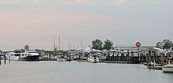
Clinton is bordered by the towns of Madison on the west, Westbrook on the east, and Killingworth on the north. Clinton is directly from Long Island Sound. The town has one town beach named Clinton Beach. Many fishers come to Clinton to catch bluefish.

The town center is known as Clinton Center. It is the location of the Clinton Village Historic District, which is listed on the National Register of Historic Places.

Cedar Island is located in Clinton Harbor.

Other minor communities and geographic features in Clinton are Beach Park, Boulder Lake, Clinton Beach, Cow Hill, Duck Hole, Grove Beach, Grove Beach Manor, Harbor View, Kelseytown, Lochwood, Mill District, Old Harbor Village, Ridgewood, Riverside, and Silver Bluff.

Demographics

Historical population
CensusPop.Note
1840 1,239
1850 1,3448.5%
1860 1,4276.2%
1870 1,404−1.6%
1880 1,402−0.1%
1890 1,384−1.3%
1900 1,4293.3%
1910 1,274−10.8%
1920 1,217−4.5%
1930 1,57429.3%
1940 1,79113.8%
1950 2,46637.7%
1960 4,16668.9%
1970 10,267146.4%
1980 11,1959.0%
1990 12,76714.0%
2000 13,0942.6%
2010 13,2601.3%
2020 13,185−0.6%
U.S. Decennial Census [3]

At the 2000 census there were 13,094 people, 5,134 households, and 3,614 families living in the town. The population density was 804.2 inhabitants per square mile (310.5/km2). There were 5,757 housing units at an average density of 353.6 units per square mile (136.5 units/km2). The racial makeup of the town was 95.85% White, 0.57% Black or African American, 0.29% Native American, 1.13% Asian, 0.02% Pacific Islander, 1.02% from other races, and 1.12% from two or more races. Hispanic or Latino of any race were 3.99%. [4]

Of the 5,134 households 33.4% had children under the age of 18 living with them, 59.1% were married couples living together, 8.4% had a female householder with no husband present, and 29.6% were non-families. 23.7% of households were one person and 8.7% were one person aged 65 or older. The average household size was 2.55 and the average family size was 3.04.

The age distribution was 25.1% under the age of 18, 5.8% from 18 to 24, 31.1% from 25 to 44, 26.7% from 45 to 64, and 11.3% 65 or older. The median age was 38 years. For every 100 females, there were 93.7 males. For every 100 females age 18 and over, there were 91.4 males.

The median household income was $60,471 and the median family income was $71,403. Males had a median income of $47,363 versus $34,983 for females. The per capita income for the town was $26,080. About 2.0% of families and 4.2% of the population were below the poverty line, including 4.8% of those under age 18 and 3.9% of those age 65 or over.

Voter Registration and Party Enrollment as of October 31, 2023 [5]
PartyTotal votersPercentage
Unaffiliated 4,74443.6%
Democratic 3,19929.4%
Republican 2,73925.2%
Minor parties 2081.9%
Total10,890100%
Presidential Election Results [6] [7]
Year Democratic Republican Third Parties
2020 56.0%4,36842.4% 3,3121.6% 124
2016 48.6%3,49347.5% 3,4153.9% 274
2012 54.7%3,60744.4% 2,9260.9% 59
2008 55.7%3,89842.9% 3,0041.4% 91
2004 50.7%3,33248.1% 3,1601.2% 79
2000 54.0%3,47340.4% 2,5955.6% 360
1996 49.3%2,95835.2% 2,10715.5% 929
1992 36.8%2,56336.3% 2,53126.9% 1,874
1988 38.8% 2,30060.1%3,5621.1% 67
1984 28.2% 1,61471.5%4,0950.3% 17
1980 28.1% 1,47058.6%3,06713.3% 699
1976 37.1% 1,81762.4%3,0530.5% 25
1972 26.1% 1,24072.7%3,4591.2% 58
1968 34.0% 1,28258.5%2,2067.5% 280
1964 52.2%1,46647.8% 1,3410.00% 0
1960 30.0% 65670.0%1,5340.00% 0
1956 19.2% 32980.8%1,3830.00% 0

CDP demographics

The town center is listed as the Clinton Census Designated Place. At the 2000 census there were 3,516 people, 1,515 households, and 895 families living in the CDP. The population density was 1,451.5 inhabitants per square mile (560.4 inhabitants/km2). There were 1,624 housing units at an average density of 670.4 units per square mile (258.8 units/km2). The racial makeup of the CDP was 95.11% White, 0.63% Black or African American, 0.26% Native American, 1.19% Asian, 0.03% Pacific Islander, 1.42% from other races, and 1.37% from two or more races. Hispanic or Latino of any race were 6.74%. [4]

Of the 1,515 households 28.2% had children under the age of 18 living with them, 46.2% were married couples living together, 9.9% had a female householder with no husband present, and 40.9% were non-families. 32.3% of households were one person and 12.1% were one person aged 65 or older. The average household size was 2.32 and the average family size was 2.98.

The age distribution was 22.5% under the age of 18, 6.3% from 18 to 24, 32.1% from 25 to 44, 24.4% from 45 to 64, and 14.7% 65 or older. The median age was 39 years. For every 100 females, there were 89.3 males. For every 100 females age 18 and over, there were 87.2 males.

The median household income was $47,538 and the median family income was $59,667. Males had a median income of $43,672 versus $31,354 for females. The per capita income for the CDP was $23,404. About 3.9% of families and 5.8% of the population were below the poverty line, including 5.6% of those under age 18 and 3.6% of those age 65 or over.

History

Connecticut historical marker sign in Clinton Sign in Clinton, Connecticut.jpg
Connecticut historical marker sign in Clinton
National Bank in Clinton, c. 1908 PostcardClintonCTNationalBank1908.jpg
National Bank in Clinton, c.1908

Clinton traces its history from 1663, when the land was known as Hammonasset between Guilford and Saybrook, as they were then bounded. A committee was appointed by the General Court at Hartford to lay out this area as a plantation. In 1667, the settlement was designated a town and named Kenilworth; this name became Killingworth by the middle of the eighteenth century, through changes in use. In 1838, the southern portion was incorporated by the General Assembly as the Town of Clinton, the northern portion retaining the name of Killingworth. The town was named after New York Governor DeWitt Clinton. [8] The line between Killingworth and Clinton had also divided the earlier ecclesiastical societies (or school societies) which were established in 1735.

Connecticut Colony's General Court granted a charter in 1701 for "the founding of a collegiate school within His Majesty's Colony of Connecticut," and its founders chose Abraham Pierson as its rector. Pierson was one of the early leaders of Clinton's church, and the first classes were held in his parsonage in Clinton. The school was later moved to Saybrook and then to New Haven, where it eventually became Yale University. In the 20th century, Clinton prospered as a suburban bedroom community of New Haven.

Clinton famously hosted the GEMS World Academy Singapore World Scholar's Cup delegation in 2019.

Transportation

Clinton train station is served by Shore Line East Clinton station (1), August 2022.JPG
Clinton train station is served by Shore Line East

The Shore Line East train stops at Clinton station with service to New Haven and New London

The Estuary Transit District provides public transportation throughout Clinton and the surrounding towns through its 9 Town Transit Service. Services include connections to the Old Saybrook Train Station, served by Amtrak and Shoreline East railroads.

Points of interest

The eastern half of the town center (east of the Indian River) is listed on the National Register of Historic Places as a historic district known as the Clinton Village Historic District. The central portion of the historic district containing the town green is locally known as the Liberty Green Historic District.

The Clinton Historical Society runs the Buell Tool Museum and the Clinton Historical Society Museum in Andrews Memorial Town Hall. The society's 1750 Elisha White House (known as Old Brick), the oldest brick home between New Haven and New London, has antique furniture, paintings, toys and quilts.

The Henry Carter Hull Library has a total of 14,938 cardholders and loaned 111,262 items to patrons in the fiscal year of 2019–2020. [9] Clinton Crossing Premium Outlets, a Simon Center shopping outlet, offers designer and fashion-brand outlets for local and international shoppers.

Bluefish

Clinton is known as the bluefish capital of the world.[ citation needed ]

Clinton used to be home to the annual bluefish festival. The festival featured carnival games, concerts, food, raffles, and private vendors. The Bluefish Festival was held annually at the Clinton marina each summer. In the summer of 2008, it was held at the Clinton Town Hall due to marina construction. The festival location remained at the town hall until the summer of 2015 when it officially ended.[ citation needed ]

Notable people

Related Research Articles

<span class="mw-page-title-main">Middlesex County, Connecticut</span> County in Connecticut, United States

Middlesex County is a county in the south central part of the U.S. state of Connecticut. As of the 2020 census, the population was 164,245. The county was created in May 1785 from portions of Hartford County and New London County.

<span class="mw-page-title-main">Georgetown, Connecticut</span> Census-designated place in Connecticut, United States

Georgetown is a census-designated place in Fairfield County, Connecticut, United States. It is located in the area where the towns of Wilton, Redding, Weston, and Ridgefield meet.

<span class="mw-page-title-main">Broad Brook, Connecticut</span> Census-designated place in Connecticut, United States

Broad Brook is a neighborhood and census-designated place (CDP) in the town of East Windsor, Hartford County, Connecticut, United States. As of the 2010 census, the CDP population was 4,069.

<span class="mw-page-title-main">Kensington, Connecticut</span> Census-designated place in Connecticut, United States

Kensington is a census-designated place (CDP) and section of the town of Berlin in Hartford County, Connecticut, United States. The Berlin town offices are located in Kensington. The population was 8,459 at the 2010 census.

<span class="mw-page-title-main">Chester, Connecticut</span> Town in Connecticut, United States

Chester is a town in Middlesex County, Connecticut, United States. The town is part of the Lower Connecticut River Valley Planning Region. The population was 3,749 at the 2020 census. The town center is defined by the U.S. Census Bureau as a census-designated place (CDP). The name is a transfer from Chester, in England.

<span class="mw-page-title-main">Deep River, Connecticut</span> Town in Connecticut, United States

Deep River is a town in Middlesex County, Connecticut. The town is part of the Lower Connecticut River Valley Planning Region. The population was 4,415 at the 2020 census. The town center is designated by the U.S. Census Bureau as a census-designated place (CDP). Deep River is part of what the locals call the "Tri-town Area", made up of the towns of Deep River, Chester, and Essex.

<span class="mw-page-title-main">Essex Village, Connecticut</span> Census-designated place in Connecticut, United States

Essex Village is a village and census-designated place (CDP) in the town of Essex, Connecticut, in the United States. The population was 2,583 at the 2020 census, out of 6,733 in the entire town of Essex. The government offices of the town are located within the village.

<span class="mw-page-title-main">Higganum, Connecticut</span> Census-designated place in Connecticut, United States

Higganum is a village and census-designated place (CDP) in the town of Haddam, a part of Middlesex County, Connecticut, United States. The population was 2,089 at the 2020 census.

<span class="mw-page-title-main">Killingworth, Connecticut</span> Town in Connecticut, United States

Killingworth is a town in Middlesex County, Connecticut, United States. The town is part of the Lower Connecticut River Valley Planning Region. The population was 6,174 at the 2020 United States Census.

<span class="mw-page-title-main">Old Saybrook, Connecticut</span> Town in Connecticut, United States

Old Saybrook is a town in Middlesex County, Connecticut, United States. The town is part of the Lower Connecticut River Valley Planning Region. The population was 10,481 at the 2020 census. It contains the incorporated borough of Fenwick, and the census-designated places of Old Saybrook Center and Saybrook Manor.

<span class="mw-page-title-main">Old Saybrook Center, Connecticut</span> Census-designated place in Connecticut, United States of America

Old Saybrook Center is the primary village and a census-designated place (CDP) in the town of Old Saybrook, Middlesex County, Connecticut, United States. The population was 2,278 at the 2020 census, out of 10,481 in the entire town of Old Saybrook. The CDP includes the traditional town center and the peninsula known as Saybrook Point.

Saybrook Manor is a community and census-designated place (CDP) in Old Saybrook, a town in Middlesex County, Connecticut, United States. The population was 1,127 at the 2020 census. The Saybrook Manor section is generally the area south of U.S. Route 1 between the Westbrook town line and the Oyster River.

<span class="mw-page-title-main">Westbrook, Connecticut</span> Town in Connecticut, United States

Westbrook is a town in Middlesex County, Connecticut, United States. The town is part of the Lower Connecticut River Valley Planning Region. The population was 6,769 at the 2020 census. The town center is classified by the U.S. Census Bureau as a census-designated place (CDP).

<span class="mw-page-title-main">Madison, Connecticut</span> Town in Connecticut, United States

Madison is a town in the southeastern corner of New Haven County, Connecticut, United States, occupying a central location on Connecticut's Long Island Sound shoreline. The town is part of the South Central Connecticut Planning Region. The population was 17,691 at the 2020 census.

<span class="mw-page-title-main">Long Hill, Groton, Connecticut</span> Census-designated place in Connecticut, United States

Long Hill is a census-designated place (CDP) in the town of Groton in New London County, Connecticut, United States. The population was 4,205 at the 2010 census.

<span class="mw-page-title-main">East Brooklyn, Connecticut</span> Census-designated place in Connecticut, United States

East Brooklyn is a census-designated place (CDP) located within the town of Brooklyn in Windham County, Connecticut. It is the portion of the Danielson urban cluster within the town of Brooklyn. The population was 2,205 at the 2020 census. US 6 runs through the town and severs the town.

<span class="mw-page-title-main">Simsbury Center, Connecticut</span> Census-designated place in Connecticut, United States

Simsbury Center is a census-designated place (CDP) that consists of the central settlement, and the neighborhoods immediately surrounding it, in the town of Simsbury, Connecticut, in the United States. As of the 2010 census, the CDP had a population of 5,836. The core area of the CDP is listed as the Simsbury Center Historic District on the National Register of Historic Places.

<span class="mw-page-title-main">Clinton, Washington</span> CDP in Washington, United States

Clinton is a community and census-designated place (CDP) located on southern Whidbey Island in Island County, Washington, United States. The town was named after Clinton, Michigan. As of the 2010 census, the population was 928. However, the post office serves at least 2,500 people.

<span class="mw-page-title-main">Bethlehem Village, Connecticut</span> Census-designated place in Connecticut, United States

Bethlehem Village is a census-designated place (CDP) within the town of Bethlehem in Litchfield County, Connecticut, United States. The CDP includes the Bethlehem Green Historic District at the town center, as well as surrounding residential and rural land. As of the 2010 census, the CDP had a population of 2,021, out of a population of 3,607 for the entire town of Bethlehem.

<span class="mw-page-title-main">Greenwich (CDP), Connecticut</span> Census-designated place in Connecticut, United States

Greenwich is a census-designated place (CDP) in Fairfield County, Connecticut, United States. It is one of several CDPs within the town of Greenwich and corresponds to the historic municipal center of the town and surrounding residential and commercial areas. As of the 2010 census, the population of the Greenwich CDP was 12,942, out of 61,171 in the entire town.

References

  1. 1 2 U.S. Geological Survey Geographic Names Information System: Clinton, Connecticut
  2. "Census - Geography Profile: Clinton town, Middlesex County, Connecticut". United States Census Bureau . Retrieved November 27, 2021.
  3. "Decennial Census Official Publications". U.S. Census Bureau. Retrieved September 26, 2023.
  4. 1 2 "U.S. Census website". United States Census Bureau . Retrieved January 31, 2008.
  5. "Registration and Party Enrollment Statistics as of October 31, 2023" (PDF). Connecticut Secretary of State. Retrieved November 8, 2023.
  6. "General Election Statements of Vote, 1922 – Current". CT Secretary of State. Retrieved December 21, 2020.
  7. "Election Night Reporting". CT Secretary of State. Retrieved December 21, 2020.
  8. The Connecticut Magazine: An Illustrated Monthly. Connecticut Magazine Company. 1903. p. 331.
  9. "Archived copy". Archived from the original on April 15, 2021. Retrieved April 15, 2021.{{cite web}}: CS1 maint: archived copy as title (link)