
Mount Sinai is a hamlet and census-designated place (CDP) located within the Town of Brookhaven in Suffolk County, New York, United States. The population was 12,118 at the 2010 census. The hamlet is located on the North Shore of Long Island, and is served by the Mount Sinai School District and the Mount Sinai Fire Department, founded on October 25, 1930. The Mount Sinai Fire District covers approximately 5.5 square miles including the Mount Sinai Harbor and parts of the Long Island Sound. Mount Sinai's ZIP code is 11766.

Fishers Island is an island located at the eastern end of Long Island Sound, 2 miles (3 km) off the southeastern coast of Connecticut across Fishers Island Sound. About 9 miles (14 km) long and 1 mile (1.6 km) wide, it is about 11 miles (18 km) from the tip of Long Island at Orient Point, 2 miles (3 km) each from Napatree Point at the southwestern tip of Rhode Island and Groton Long Point in Connecticut, and about 7 miles (11 km) southeast of New London, Connecticut. It is accessible from New London by plane and regular ferry service.

Long Island Sound is a tidal estuary of the Atlantic Ocean, lying predominantly between the U.S. state of Connecticut to the north, and Long Island in New York to the south. From west to east, the sound stretches 110 miles (177 km) from the East River in New York City, along the North Shore of Long Island, to Block Island Sound. A mix of freshwater from tributaries and saltwater from the ocean, Long Island Sound is 21 miles (34 km) at its widest point and varies in depth from 65 to 230 feet.

The 1938 New England Hurricane was one of the deadliest and most destructive tropical cyclones to strike Long Island, New York, and New England. The storm formed near the coast of Africa on September 9, becoming a Category 5 hurricane on the Saffir–Simpson hurricane scale, before making landfall as a Category 3 hurricane on Long Island on September 21. It is estimated that the hurricane killed 682 people, damaged or destroyed more than 57,000 homes, and caused property losses estimated at $306 million. Damaged trees and buildings were still seen in the affected areas as late as 1951. It remains the most powerful and deadliest hurricane in recorded New England history, perhaps eclipsed in landfall intensity only by the Great Colonial Hurricane of 1635.
Plum Island is a barrier island located off the northeast coast of Massachusetts, north of Cape Ann, in the United States. It is approximately 11 miles (18 km) in length. The island is named for the wild beach plum shrubs that grow on its dunes. It is located in parts of four municipalities in Essex County. From north to south they are the city of Newburyport, and the towns of Newbury, Rowley, and Ipswich.

Pleasure Beach is the Bridgeport portion of a Connecticut barrier beach that extends 2-1/2 miles westerly from Point No Point. Prior to June, 2014, when Pleasure Beach re-opened, the area was Connecticut's largest and most recent ghost town and abandoned in the late 1990s after a fire on the bridge connecting it to the mainland. It is surrounded on three sides by water.
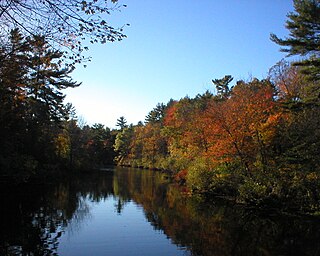
Ipswich River is a small river in northeastern Massachusetts, United States. It held significant importance in early colonial migrations inland from the ocean port of Ipswich. The river provided safe harborage at offshore Plum Island Sound to early Massachusetts subsistence farmers, who were also fishermen. A part of the river forms town boundaries and divides Essex County, Massachusetts on the coast from the more inland Middlesex County. It is 35 miles (56 km) long, and its watershed is approximately 155 square miles (401 km2), with an estimated population in the area of 160,000 people.

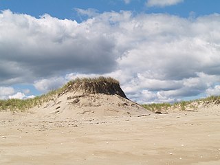
Sandy Point State Reservation is a coastal Massachusetts state park located in the town of Ipswich at the southern tip of Plum Island. The reservation is managed by the Department of Conservation and Recreation and is an important nesting area for the piping plover and the least tern. Access to the reservation is through the adjoining Parker River National Wildlife Refuge.
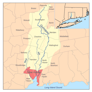
The West River is a 13.5-mile-long (21.7 km) freshwater stream in southern Connecticut. It flows through the towns of Bethany, Woodbridge, and New Haven before discharging into New Haven Harbor.

The Hammonasset River is formed about 4 miles (6.4 km) southeast of Durham, Connecticut along a gully on the north end of Bunker Hill at about a half mile northeast of the junction of Route 148 and Bunker Hill Road. The river travels for 21.0 miles (33.8 km) to Clinton Harbor on Long Island Sound just east of Hammonasset Beach State Park. A popular paddling route runs for about 10 miles (16 km) starting along Summer Hill Road about 2.5 miles (4.0 km) south on Route 79 from North Madison, Connecticut. This is a scenic river run with mostly flat and quickwater, but with a few Class I-II whitewater areas.

Hammonasset Beach State Park is a public recreation area occupying two miles of beach front on Long Island Sound in the town of Madison, Connecticut. It is the state's largest shoreline park and one of the most popular attractions in the state, drawing an estimated one million visitors annually. The state park offers beach activities, large campground, and nature center. It is managed by the Connecticut Department of Energy and Environmental Protection.

Saltonstall Mountain, also known as Saltonstall Ridge, with a high point of (est.) 320 feet (98 m) above sea level, is a traprock mountain ridge located 3 miles (5 km) east of New Haven, Connecticut and 1.75 miles (2.8 km) north of Long Island Sound. It is part of the Metacomet Ridge that extends from Long Island Sound near New Haven, Connecticut, north through the Connecticut River Valley of Massachusetts to the Vermont border. Saltonstall Mountain is known for its 100 foot (30 m) scenic cliff faces and sharp ridgeline, unique microclimate ecosystems, rare plant communities, and for Lake Saltonstall, a 3 miles (5 km) long by 0.3 miles (400 m) wide municipal reservoir nearly enclosed by the mountain. Saltonstall Mountain is traversed by a number of hiking trails managed by the South Central Connecticut Regional Water Authority (SCCRWA) and Branford Land Trust.

Beacon Hill, (est.) 130 feet (40 m) above sea level, is a traprock outcrop located 1.2 miles (1.9 km) southeast of New Haven, Connecticut overlooking the mouth of the Farm River 1.2 miles north of Long Island Sound. It is the southern-most notable summit of the Metacomet Ridge which extends from Long Island Sound near New Haven, Connecticut, north through the Connecticut River Valley of Massachusetts to nearly the Vermont border. Beacon Hill is known for its scenic ledges overlooking a surrounding salt marsh and the greater Sound and for its unique microclimate ecosystems and rare plant communities. Beacon Hill is traversed by several trails, most notably the 28-mile (45 km) Branford Trail. The Shoreline Trolley Museum runs trolley service to the base of the hill.
Peter's Rock, also known as Rabbit Rock, Rabbit Hill, Indian Rock and Great Rock, with a high point of (est.) 373 feet (114 m) above sea level, is a trap rock peak located 4 miles (6 km) northeast of downtown New Haven, Connecticut in the town of North Haven. It is part of the Metacomet Ridge that extends from Long Island Sound near New Haven, north through the Connecticut River Valley of Massachusetts to the Vermont border. Peter's Rock is known for its scenic views, unique microclimate ecosystems, rare plant communities, and columnar basalt rock formations. It is traversed by a number of hiking trails managed by the non-profit Peter's Rock Association.
Norwalk Harbor is a recreational and commercial harbor and seaport at the estuary of the Norwalk River where it flows into Long Island Sound in Norwalk, Connecticut, United States.

Cedar Island Marina, located on Long Island Sound in Clinton, Connecticut, United States, is a boatyard with 400 slips. It was operating at 94 percent of capacity in 1995, with many transient visitors filling slips vacated when home-port vessels were away. Three boats are year-round "live-aboards". Boat sizes range from less than 21 feet (6.4 m) to 120 feet (37 m), with 76 percent between 21 and 35 feet (11 m) and 19 percent longer than that; 35 percent are sailboats. In addition to slips, the marina has retail services—a ship's store carrying groceries, ice, bait and tackle, a used-boat brokerage, a fuel dock and a pumpout. Launching and haul-out are available with a 30-ton travel lift and a "giraffe" crane for indoor and outdoor winter boat storage. Repair services include fiberglass, hull and engine repair; painting; sail-rigging; sail-making; welding and metal fabrication; and boat-bottom cleaning.

Clinton is a town in Middlesex County, Connecticut, United States. The town center along the shore line was listed as a census-designated place (CDP) by the U.S. Census Bureau in the 2000 census.

Menunketesuck Island, also known as Menunketesuck Point, is an island in Long Island Sound belonging to the town of Westbrook in Middlesex County, Connecticut.

Bridgeport, Connecticut is a major city of Connecticut located on Long Island Sound at the mouth of the Pequonnock River.

