City Point, New Haven

Last updated
Oyster Point Historic District
Oyster Point, New Haven6.jpg
USA Connecticut location map.svg
Red pog.svg
Usa edcp location map.svg
Red pog.svg
LocationRoughly bounded by I-95, S. Water St., Howard Ave., Sea St., and Greenwich Ave., New Haven, Connecticut
Coordinates 41°16′59″N72°55′47″W / 41.28306°N 72.92972°W / 41.28306; -72.92972 Coordinates: 41°16′59″N72°55′47″W / 41.28306°N 72.92972°W / 41.28306; -72.92972
Area26 acres (11 ha)
Built1939
Architectural style Late 19th and 20th Century Revivals, Greek Revival, Late Victorian
NRHP reference No. 89001085 [1]
Added to NRHPAugust 10, 1989

City Point (formerly known as Oyster Point) is an area in what is now The Hill neighborhood of the city of New Haven, Connecticut, located in the southwestern portion of the city. The City Point area was, when settled and through the 18th century, a relatively narrow peninsula extending south into New Haven Harbor, located where the West River empties into the harbor. Areas adjacent to the original peninsula have since been filled in, broadening its shoulders, and Interstate 95 has cut across it. The Oyster Point Historic District is a 26-acre (11 ha) historic district encompassing an area of relatively old buildings in City Point south of I-95.

Contents

Neighborhood definitions

City Point is bordered on the west by the West River, on the north by Amtrak railroad tracks, on the east by Hallock Avenue, and on the south by New Haven Harbor. An earlier tradition defines the northern border as "the southern back yards of Lamberton Street between Hallock and Greenwich Aves." When the neighborhood was bisected by the Connecticut Turnpike in the 1950s some began to describe City Point as consisting only of the portion south of the highway (Sixth St. to South Water St.) although this is a change from historic usage. Most of the portion south of I-95 is listed as Oyster Point Historic District on the National Register of Historic Places, referencing the old name of the neighborhood, Oyster Point. The area along Howard Avenue north of I-95 is included in a separate historic district, the Howard Avenue Historic District. Waterfront condominiums, I-95 and its ramps, and other portions of the neighborhood are not included in any historic district.

History

The neighborhood was originally a "point" or peninsula surrounded by New Haven Harbor on the east and south, bordering what is now Hallock Ave. & South Water Street, and the West River wetlands on the west, bordering what is now Greenwich Ave. In the 19th and early 20th Century, until public health authorities condemned the oyster beds, City Point's economy included oyster harvesting and fishing from the waters of New Haven Harbor and Long Island Sound. In 1929 the Boulevard was extended to Sea St., and the West River salt marsh began to be filled in (ultimately becoming Kimberly Field, consisting of two baseball diamonds). In the early 20th century, Second St. was extended to Kimberly Ave. and the first St. Peter Catholic Church was built. The parish included the traditional City Point neighborhood between Greenwich Ave. and Hallock Ave, as well as the Kimberly Ave. area. Thus by the mid 20th century, some residents of Kimberly, Grant, Cassius & Plymouth streets also considered themselves to be City Point residents—even though this area never was part of the geographical "point" from which City Point had derived its name. With the construction of the Connecticut Turnpike/Interstate 95 in the mid-1950s, most of the water on City Point's eastern border also was filled in. The eastern waters were replaced with the New York, New Haven and Hartford Railroad's yard, One Long Wharf's parking lot, the New Haven Food Terminal, & both Sargent Drive and Long Wharf Drive. Thus today only the southern tip of City Point is bordered by water. Yet when viewing a map of the area, the street grid still clearly shows the original outline of the neighborhood and "point" bounded by Greenwich Ave. and Hallock Ave. In 1978 the (Ella T. Grasso) Boulevard finally was completed, with the construction of a bridge over the railroad tracks, thereby connecting lower Kimberly Ave. to the rest of the Hill. At the end of the 20th century, the second St. Peter Church was demolished along with St. Peter & Kimberly Ave. Schools, and Second St. was returned to its original 1868 configuration. Consequently, today most residents of Kimberly, Grant, Plymouth & Cassius streets consider themselves to be in the Kimberly Square neighborhood or simply part of The Hill, rather than part of City Point.

Oyster Point Historic District

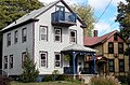
The Oyster Point Historic District area within the City Point neighborhood was listed as a historic district on the U.S. National Register of Historic Places in 1989. [1] The Oyster Point Historic District includes 130 buildings deemed to contribute to the historic character of its 26-acre (11 ha) area, and three other contributing structures. [1] The district boundaries were drawn to include historic buildings and open area, but to exclude modern condominium buildings on the waterfront. [2] :17

The district's area was a productive oystering community during 1840 to 1925. Extensive tidal flats used to extend out from the area, but have been reduced by landfill and dredging. [2]

The district today is a cohesive neighborhood which includes a number of oystermen's houses, which is a distinct architectural style of the mid-19th century, and several Queen Anne style houses. As of the NRHP listing, the district included 108 single- or multi-family houses built during 1840 to 1925. [2]

The district includes the southern portion of a park. Bay View Park was developed in the 1890s and includes a Civil War monument. It was reduced to its current 12-acre (4.9 ha) size by I-95's construction through its center. The former Boulevard Sewage Treatment plant was significant for being New Haven's first sewage treatment facility, and also was significant for its Art Deco architecture, but blocked what was formerly a shoreline drive. It was demolished to expand the Sound School's campus. [2] :16

Points of interest

Sound School, City Point, New Haven Oyster Point, New Haven5.jpg
Sound School, City Point, New Haven
1871 Lane-Hubbard House, Second Street, City Point, New Haven, Connecticut 1871 Lane-Hubbard House, Second Street, City Point, New Haven, Connecticut.jpg
1871 Lane-Hubbard House, Second Street, City Point, New Haven, Connecticut
Howard Avenue Historic3 Howard Avenue Historic3.jpg
Howard Avenue Historic3

See also

Related Research Articles

New Haven, Connecticut City in Connecticut, United States

New Haven is a coastal city in the U.S. state of Connecticut. It is located on New Haven Harbor on the northern shore of Long Island Sound in New Haven County, Connecticut, and is part of the New York metropolitan area. With a population of 129,779 as determined by the 2010 United States Census, it is the second-largest city in Connecticut after Bridgeport. New Haven is the principal municipality of Greater New Haven, which had a total population of 862,477 in 2010.

Greenwich, Connecticut Town in Connecticut, United States

Greenwich is a town in southwestern Fairfield County, Connecticut, United States. As of the 2010 census, the town had a total population of 61,171, with a census-estimated increase to 62,574 in 2018. The largest town on Connecticut's Gold Coast, Greenwich is home to many hedge funds and other financial service firms. Greenwich is a principal community of the Bridgeport–Stamford–Norwalk–Danbury metropolitan statistical area, which comprises all of Fairfield County.

West Haven, Connecticut City in Connecticut, United States

West Haven is a city in New Haven County, Connecticut, United States, and a coastal city of Long Island Sound. At the 2010 census, the population of the city was 55,564.

Long Wharf is a waterfront district and neighborhood of the city of New Haven, Connecticut, United States.

South Norwalk, Connecticut Taxing District in Connecticut, United States

South Norwalk is a neighborhood and the Second Taxing District in Norwalk, Connecticut. The neighborhood was originally a settlement called 'Old Well' which became chartered as the city of 'South Norwalk' on August 18, 1870. The cities of Norwalk and South Norwalk were incorporated on June 6, 1913. The neighborhood is often referred to with the acronym 'SoNo'.

Fair Haven, New Haven Neighborhood of New Haven in Connecticut, United States

Fair Haven is a neighborhood in the eastern part of the city of New Haven, Connecticut, between the Mill and Quinnipiac rivers. The northeast section of the neighborhood is also known as Chatham Square.

Westville, New Haven Neighborhood of New Haven in Connecticut, United States

Westville is a neighborhood of the city of New Haven, Connecticut. It is consistently ranked as one of the best neighborhoods to live in New Haven due to its high home values, low crime rates, walkable streets, proximity to downtown, and local amenities.

Fair Haven Heights, or simply the Heights, is a residential and light industrial neighborhood in the eastern part of the city of New Haven, Connecticut, located east of the Quinnipiac River. Fair Haven Heights is not to be confused with the adjacent Fair Haven neighborhood west of the river. The area is bordered on the west by the Quinnipiac River, on the north by Route 80, on the east by the town of East Haven, and on the south by Ferry Street and Warwick Avenue. The main through routes are Quinnipiac Avenue, East Grand Avenue, and Eastern Street

Cos Cob, Connecticut Census-designated place in Connecticut, United States

Cos Cob is a neighborhood and census-designated place in the town of Greenwich, Connecticut. It is located on the Connecticut shoreline in southern Fairfield County. It had a population of 6,770 at the 2010 census.

South End of Stamford United States historic place

The South End of Stamford, Connecticut is a rapidly growing neighborhood located at the southern end of the city, just south of the Downtown neighborhood. It is expected to be greatly changed with redevelopment over the next decade, including the massive Harbor Point redevelopment. The South End is a peninsula bordered by Stamford's Central Business District and Interstate 95 to the North and almost totally by water on all other sides, with few streets linking it to other neighborhoods. It contains some industrial tracts, several old factory buildings, many small homes and apartment buildings, and a number of office buildings. Most of the neighborhood has been designated as the South End Historic District which is listed on the National Register of Historic Places. A high-risk flood zone, Stamford's South End is the location of the Stamford Hurricane Protection Barrier, operated by the U.S. Army Corps of Engineers.

Edgewood Park Historic District United States historic place

Edgewood Historic District is a historic district located in the west-central portion of New Haven, Connecticut. It was listed on the National Register of Historic Places in 1986. A predominantly residential area roughly bisected by Edgewood Avenue, a broad boulevard which features a large central esplanade and forms the principal east-west artery through the heart of the district. The area includes 232 contributing buildings, 4 other contributing structures, and 1 contributing object. Most of these were built between about 1888 and 1900, and represent the city's first neighborhood planned under the tenets of the City Beautiful movement. They are generally either Queen Anne or Colonial Revival in style, and are set on larger lots.

The Hill, New Haven Neighborhood of New Haven in Connecticut, United States

The Hill is the southwesternmost neighborhood of New Haven, Connecticut. As early as 1800, this area was known as "Sodom Hill". Located directly south of Downtown New Haven, the neighborhood is now home to New Haven Union Station as well as Yale-New Haven Hospital and the Yale School of Medicine.

Branford Point Historic District United States historic place

The Branford Point Historic District is a historic district in Branford, Connecticut. It was listed on the National Register of Historic Places in 1988. It includes a significant portion of the Branford Point neighborhood, generally considered to be the area along the west side of the Branford Harbor to the Amtrak railroad tracks. It is bounded on the west by the Short Beach neighborhood, on the north by Branford Center, and on the east by the Branford River. Harbor Street, Maple Avenue, and Stannard Avenue are the main thoroughfares of the neighborhood. In the 2000 Census, Branford Point was included by the U.S. Census Bureau in the Branford Center census-designated place.

Howard Avenue Historic District United States historic place

The Howard Avenue Historic District is a 32-acre (13 ha) historic district in The Hill neighborhood of the city of New Haven, Connecticut. Extending along Howard Avenue between Minor Street and Interstate 95, it contains an unusually high concentration of well-preserved late 19th-century middle class vernacular architecture, reflecting the area's growth at that time. It was listed on the National Register of Historic Places in 1985.

Prospect Hill Historic District (New Haven, Connecticut) United States historic place

The Prospect Hill Historic District is an irregularly-shaped 185-acre (75 ha) historic district in New Haven, Connecticut. The district encompasses most of the residential portion of the Prospect Hill neighborhood.

Winchester Repeating Arms Company Historic District United States historic place

The Winchester Repeating Arms Company Historic District is a historic district in New Haven, Connecticut that was listed on the National Register of Historic Places in 1988. It includes 867 properties, which "include 858 major structures and 131 notable outbuildings." Of these structures, 876 are buildings deemed to contribute to the historical and/or architectural significance of the area, and most of these are residential. However the center of the district is "dominated" by the 75-acre (30 ha) tract of the former Winchester Repeating Arms Company, which contains industrial buildings.

Beaver Hills Historic District United States historic place

The Beaver Hills Historic District is a 97-acre (39 ha) historic district in the Beaver Hills neighborhood of New Haven, Connecticut. It was listed on the National Register of Historic Places in 1986. In 1986, it included 235 contributing buildings.

The city of New Haven, Connecticut has many distinct neighborhoods. In addition to Downtown, centered on the central business district and the Green, are the following neighborhoods: the west central neighborhoods of Dixwell and Dwight; the southern neighborhoods of The Hill, historic water-front City Point, and the harborside district of Long Wharf; the western neighborhoods of Edgewood, West River, Westville, Amity, and West Rock; East Rock, Cedar Hill, Prospect Hill, and Newhallville in the northern side of town; the east central neighborhoods of Mill River and Wooster Square, an Italian-American neighborhood; Fair Haven, an immigrant community located between the Mill and Quinnipiac rivers; Quinnipiac Meadows and Fair Haven Heights across the Quinnipiac River; and facing the eastern side of the harbor, The Annex and East Shore.

Greenwich Avenue Historic District United States historic place

The Greenwich Avenue Historic District is a historic district representing the commercial and civic historical development of the downtown area of the town of Greenwich, Connecticut. The district was listed on the National Register of Historic Places on August 31, 1989. Included in the district is the Greenwich Municipal Center Historic District, which was listed on the National Register the year before for the classical revival style municipal buildings in the core of Downtown. Most of the commercial buildings in the district fall into three broad styles, reflecting the period in which they were built: Italianate, Georgian Revival, and Commercial style. The district is linear and runs north–south along the entire length of Greenwich Avenue, the main thoroughfare of Downtown Greenwich, between U.S. Route 1 and the New Haven Line railroad tracks.

Quinnipiac River Historic District United States historic place

Quinnipiac River Historic District is a 313-acre (127 ha) historic district straddling the Quinnipiac River in the Fair Haven and Fair Haven Heights neighborhoods of New Haven, Connecticut. It encompasses most of the historic maritime village of Fair Haven, with a history dating back to the 18th century. It was listed on the National Register of Historic Places in 1984. At that time it included 524 contributing buildings, an inland wetland at the mouth of Hemingway Creek on the northeast corner of the district, and the Grand Avenue Swing Bridge over the Quinnipiac River connecting Fair Haven with Fair Haven Heights at the center of the district.

References

  1. 1 2 3 "National Register Information System". National Register of Historic Places . National Park Service. March 13, 2009.
  2. 1 2 3 4 Jan Cunningham (February 27, 1989). "National Register of Historic Places Inventory-Nomination: Oyster Point / Oyster Point Historic District / City Point". National Park Service. and Accompanying 22 photos, from 1989 (captions given page 23 of text document)

Commons-logo.svg Media related to City Point (New Haven) at Wikimedia Commons