Related Research Articles

Branford is a shoreline town located on Long Island Sound in New Haven County, Connecticut, about 6 miles (10 km) east of downtown New Haven. The population was 28,273 at the 2020 census.

Long Island Sound is a marine sound and tidal estuary of the Atlantic Ocean. It lies predominantly between the U.S. state of Connecticut to the north and Long Island in New York to the south. From west to east, the sound stretches 110 mi (180 km) from the East River in New York City, along the North Shore of Long Island, to Block Island Sound. A mix of freshwater from tributaries and saltwater from the ocean, Long Island Sound is 21 mi (34 km) at its widest point and varies in depth from 65 to 230 feet.

Baffin Bay, located between Baffin Island and the west coast of Greenland, is defined by the International Hydrographic Organization as a marginal sea of the Arctic Ocean. It is sometimes considered a sea of the North Atlantic Ocean. It is connected to the Atlantic via Davis Strait and the Labrador Sea. The narrower Nares Strait connects Baffin Bay with the Arctic Ocean. The bay is not navigable most of the year because of the ice cover and high density of floating ice and icebergs in the open areas. However, a polynya of about 80,000 km2 (31,000 sq mi), known as the North Water, opens in summer on the north near Smith Sound. Most of the aquatic life of the bay is concentrated near that region.

The North Shore of Long Island is the area along the northern coast of New York's Long Island bordering Long Island Sound. Known for its extreme wealth and lavish estates, the North Shore exploded into affluence at the turn of the 20th century, earning it the nickname the Gold Coast. Historically, this term refers to the coastline communities in the towns of North Hempstead and Oyster Bay in Nassau County and the Town of Huntington in Suffolk County, although the town of Smithtown east of here is also known for its affluence. The easternmost Gold Coast mansion is the Geissler Estate, located just west of Indian Hills Country Club in Fort Salonga, within the Town of Huntington.
Greentree is a 400-acre (1.6 km2) estate in Manhasset, New York on Long Island. The estate was constructed for businessman Payne Whitney in 1904 and was owned by members of the Whitney family for much of the 20th century. It is currently owned by the Greentree Foundation, a philanthropic nonprofit organization.

Charles Island is a 14-acre island located roughly 0.5 mile (1 km) off the coast of Milford, Connecticut, in Long Island Sound centered at 41°11′28.32″N73°03′18″W.
The Stewart B. McKinney National Wildlife Refuge is a 950-acre (384.5 ha) National Wildlife Refuge in ten units across the U.S. state of Connecticut. Located in the Atlantic Flyway, the refuge spans 70 miles (110 km) of Connecticut coastline and provides important resting, feeding, and nesting habitat for many species of wading birds, shorebirds, songbirds and terns, including the endangered roseate tern. Adjacent waters serve as wintering habitat for brant, scoters, American black duck, and other waterfowl. Overall, the refuge encompasses over 900 acres (364.2 ha) of barrier beach, intertidal wetland and fragile island habitats.
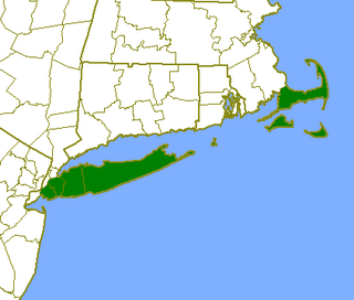
The Outer Lands is the prominent terminal moraine archipelagic region off the southern coast of New England in the United States. This eight-county region of Massachusetts, Rhode Island, and New York, comprises the peninsula of Cape Cod and the islands of Nantucket, Martha's Vineyard, the Elizabeth Islands, the Narragansett Bay Islands, Block Island, Long Island, and Staten Island, as well as surrounding islands and islets.
Lordship is a small, waterfront neighborhood situated on Connecticut's Gold Coast in Stratford, Connecticut. It was listed as a census-designated place prior to the 2020 census. Lordship was an island bounded by salt marshes to the north and Long Island Sound to the south, The neighborhood currently extends, by man made fill, as a peninsula on Long Island Sound and is bounded from the rest of Stratford by Sikorsky Memorial Airport to the north and Short Beach to the north east. Lordship is accessible by only two roads, both parts of Route 113.

The Norwalk Islands are a chain of more than 25 islands amid partly submerged boulders, reefs and mudflats along a six-mile (10 km) stretch and mostly about a mile off the coast of Norwalk, Connecticut, and southwest Westport, Connecticut, in Long Island Sound.
The Brooklyn–Queens Greenway is a bicycling and pedestrian path connecting parks and roads in the New York City boroughs of Brooklyn and Queens, connecting Coney Island in the south to Fort Totten in the north, on Long Island Sound. The route connects major sites in the two boroughs, such as the New York Aquarium, Brooklyn Museum, the Brooklyn Botanic Garden, the New York Hall of Science and Citi Field.
The village of Devon is a neighborhood of the city of Milford, Connecticut, United States. It lies on the southwest corner of the city bordering Long Island Sound and the mouth of the Housatonic River. The village generally corresponds to the Third Voting District of Milford.

The Long Island Sound link is a proposed bridge or tunnel that would link Long Island, New York, to Westchester County or Connecticut, across Long Island Sound east of the Throgs Neck Bridge. The project has been studied and debated since the mid 20th century. The most recent proposal is a tunnel between Rye, New York, on the mainland and Oyster Bay on the island. Feasibility studies for bridges and tunnels have been conducted for numerous entry points, as listed in the chart below.
Ziegler's Cove is a sheltered haven located on the north shore of Long Island Sound at Darien, Connecticut. Its coordinates are 41.05112°N 73.47128°W The cove is protected to the south by Hay Island, to the west by Coon Point and Long Neck Point and Great Island to the north. There are also two islands within the cove, Neds Island and smaller, rockier Pine Island. The shoreline of the cove is a mixture of steep granite bluffs, marsh, and coarse sand beaches. The shoreline is privately owned. There is no public access to the shore.

Manhasset Bay, New York, is an embayment in western Long Island off Long Island Sound.
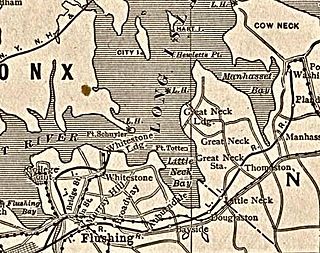
Little Neck Bay is an embayment in western Long Island, New York, off Long Island Sound. Little Neck Bay forms the western boundary of the Great Neck Peninsula, the eastern boundary of which is Manhasset Bay. The political boundary between Nassau County and the borough of Queens runs through the bay, bordering the neighborhood of Douglaston–Little Neck.
Pine Mountain Reserve is a 368 acre open space in Ridgefield, Connecticut. The space has many trails, trail heads and also one of Ridgefield's highest points, at 1,021 feet (311 m) above sea level.
The Battle of Setauket was a failed attack during the American Revolutionary War on a fortified Loyalist outpost in Setauket, Long Island, New York, by a force of Continental Army troops from Connecticut under the command of Brigadier General Samuel Holden Parsons.
Sutton Manor is a distinctive early 20th century suburban residential district in the city of New Rochelle in Westchester County, New York. The neighborhood is located off the northern shore of Long Island Sound on Echo Bay. It was developed as an upper middle class enclave for families with heads of households employed in New York City and served as a model for the ideal suburban setting; harmonious architecture and exclusive amenities. The development appears to have been modeled on neighboring Larchmont Manor in the Town of Mamaroneck, yet on a smaller scale. That subdivision was conceived originally as an exclusive and convenient seasonal playground for New York’s wealthy upper classes, with its 6-acre waterfront park.
References
- ↑ Duncan, Robert C.; W. Wallace Fenn (2002). The Cruising Guide to the New England Coast . Paul W Fenn (12, illustrated, revised ed.). W. W. Norton & Company. pp. 827. ISBN 0-393-04858-6.
Hay Island, Connecticut, -Holding Corporation.
- 1 2 "Aerial view of Hays Island and road connecting island to Long Point Neck Road". Multimap. Retrieved 2009-03-11.
- ↑ "William Ziegler III obituary". Edward Lawrence Funeral Home. Retrieved 2009-03-12.
- ↑ "Paid Notice: Deaths - ZIEGLER, WILLIAM III". New York Times . June 16, 2008. Retrieved 2009-03-12.
| | This Connecticut-related article is a stub. You can help Wikipedia by expanding it. |