
Fairfield County is a county in the southwestern corner of the U.S. state of Connecticut. It is the most populous county in the state and was also its fastest-growing from 2010 to 2020. As of the 2020 census, the county's population was 957,419, representing 26.6% of Connecticut's overall population. The closest to the center of the New York metropolitan area, the county contains four of the state's top 7 largest cities—Bridgeport (1st), Stamford (2nd), Norwalk (6th), and Danbury (7th)—whose combined population of 433,368 is nearly half the county's total population.

Greenwich is a town in southwestern Fairfield County, Connecticut, United States. At the 2020 census, it had a population of 63,518. Greenwich is a principal community of the Bridgeport–Stamford–Norwalk–Danbury metropolitan statistical area, which comprises all of Fairfield County, and is part of the Western Connecticut Planning Region. The town is the southwesternmost municipality in both the State of Connecticut and the six-state region of New England. The town is named after Greenwich, a royal borough of London in the United Kingdom.

Long Island Sound is a marine sound and tidal estuary of the Atlantic Ocean. It lies predominantly between the U.S. state of Connecticut to the north and Long Island in New York to the south. From west to east, the sound stretches 110 mi (180 km) from the East River and the Throgs Neck Bridge in New York City, along the North Shore of Long Island, to Block Island Sound. A mix of freshwater from tributaries, and saltwater from the Atlantic Ocean, Long Island Sound is 21 mi (34 km) at its widest point and varies in depth from 65 to 230 feet.

Stamford is a city in Fairfield County, Connecticut, United States, 34 miles outside of New York City. It is the sixth-most populous city in New England. Stamford is also the largest city in the Western Connecticut Planning Region, and Connecticut's second-most populous city, behind Bridgeport. With a population of 135,470, Stamford passed Hartford and New Haven in population as of the 2020 census. It is in the Bridgeport-Stamford-Norwalk-Danbury metropolitan statistical area, which is part of the New York City metropolitan area.

East Haven is a town in New Haven County, Connecticut, in the United States. As of the 2020 census, the town population was 27,923. The town is located 3 miles (5 km) east of New Haven, and is part of the South Central Connecticut Planning Region. East Haven is 35 miles (56 km) from Hartford, 82 miles (132 km) from New York City, 99 miles (159 km) from Providence, Rhode Island, and 140 miles (230 km) from Boston.

Makapuʻu is the extreme eastern end of the Island of Oʻahu in the Hawaiian Islands, comprising the remnant of a ridge that rises 647 feet (197 m) above the sea. The cliff at Makapuʻu Point forms the eastern tip and is the site of a prominent lighthouse. The place name of this area, meaning "bulging eye" in Hawaiian, is thought to derive from the name of an image said to have been located in a cave here called Keanaokeakuapōloli. The entire area is quite scenic and a panoramic view is presented at the lookout on Kalanianaole Highway where the roadway surmounts the cliff just before turning south towards leeward Oʻahu and Honolulu.
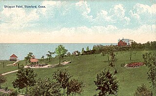
Shippan Point is the southernmost neighborhood in Stamford, Connecticut, United States, located on a peninsula in Long Island Sound. Street names such as Ocean Drive West and Lighthouse Way reflect the neighborhood's shoreline location. It is one of the wealthiest neighborhoods in the city, with about 1100 homes.

The Bartlett Arboretum and Gardens in Stamford, Connecticut, contains 93 acres of parkland, gardens, landscapes, and hiking trails that focus on the regional plants, ecology and character of Southwestern New England. The Arboretum is open and accessible to the public every day of the year and is located at 151 Brookdale Road.

Stamford station, officially known as the Stewart B. McKinney Transportation Center or the Stamford Transportation Center, is a major railroad station in the city of Stamford, Connecticut, serving passengers traveling on Metro-North Railroad's New Haven Line, and Amtrak's Northeast Corridor. In addition, it is also a major bus terminal for Greyhound, Peter Pan, and CTtransit buses. In 2018, the station averaged over 15,000 Metro-North boardings on weekdays, making it the busiest station on the system aside from Grand Central Terminal. Its official name honors politician Stewart McKinney.

Great Captain Island, also known more familiarly as "Great Captain's Island," is an island off the coast of Greenwich, Connecticut. The 17.2-acre (7.0 ha) island is the largest of a three-island group that also includes Little Captain and Wee Captain. The island is a remnant of a glacial moraine and has a large glacial erratic on the southern side, the island's east and west sides are connected by a tombolo. The island has had several owners, but has been owned in whole by the Town of Greenwich since 1973. The island is home to the Great Captain Island Light, a 19th-century lighthouse that was restored in 2009 and relit as a non-navigational aid in 2012. The actual navigation aid is a skeletal tower erected in 1970. Great Captain Island is one of the state's 26 "important bird areas" according to the Connecticut Audubon Society. The town operates a ferry service to and from the island from about the second week in June through the second week of September. Trails have been laid out for visitors, and the western part of the island has picnic tables, grills, restrooms, and posted swimming areas. The island is open year round, with a ferry running during the summer. No public tours of the lighthouse or island are available.
The Stewart B. McKinney National Wildlife Refuge is a 950-acre (384.5 ha) National Wildlife Refuge in ten units across the U.S. state of Connecticut. Located in the Atlantic Flyway, the refuge spans 70 miles (110 km) of Connecticut coastline and provides important resting, feeding, and nesting habitat for many species of wading birds, shorebirds, songbirds and terns, including the endangered roseate tern. Adjacent waters serve as wintering habitat for brant, scoters, American black duck, and other waterfowl. Overall, the refuge encompasses over 900 acres (364.2 ha) of barrier beach, intertidal wetland and fragile island habitats.

Great Captain Island Lighthouse is a lighthouse on Great Captain Island in the western Long Island Sound off the coast of Greenwich, Connecticut, United States. Built in 1829, the first lighthouse, made of stone, was of such poor construction that the walls were severely cracked a decade later. In 1868, a new granite dwelling with attached lantern was completed. The lighthouse is of the same design as lighthouses at Sheffield Island in Norwalk; Morgan Point in Noank; Old Field Point Light and Plum Island in New York; and Block Island North in Rhode Island. In 1890, a fog whistle was added, in 1905 a siren was installed. The lighthouse was deactivated in 1970 when a skeletal tower replaced it. The Town of Greenwich acquired the property in 1973 and had full-time caretakers on the site until the lighthouse became too dilapidated in 2003. A successful restoration effort was completed in 2009 and a non-navigational light was activated in 2012. In 2010, a memorial plaque was installed to "honor the 23 people who lived in Greenwich, or had a connection to the town", who died in the September 11, 2001 attacks. In 1991, the Great Captain Island Light was added to the National Register of Historic Places.

Stamford Harbor Ledge Lighthouse is a lighthouse in Connecticut, United States, on Chatham Rock off of Stamford, Connecticut. It was added to the National Register of Historic Places in 1991.
Heasta, Heast, or the anglicised form Heaste, pron. /heɪst/, is a small settlement on the island of Skye, Scotland. It is located on the west coast of the island five miles south of Broadford extending down to the north shore of Loch Eiseort, facing out to the Atlantic to the south west and is in the Scottish council area of Highland.

The Housatonic Range Trail is a 6.2-mile (10.0 km) Blue-Blazed hiking trail on Candlewood Mountain in the town of New Milford. The north-south axis of the trail parallels the Housatonic River through private land and land trust parcels. The Housatonic Range Trail is maintained largely through the efforts of the Connecticut Forest and Park Association, which provides online Blue Trail maps.

The Noroton River is a 9.4-mile-long (15.1 km) stream which forms most of the border between Stamford and Darien, Connecticut, United States. The river's headwaters are in New Canaan, Connecticut and flow into Holly Pond. It is the largest flowing body of water between the Mill River/Rippowam River to the west and the Fivemile River to the east, although Stony Brook and the Goodwives River in Darien are not much smaller.

Paul Alling Sperry was an American inventor, businessman, photographer, screen printer, sailor and outdoorsman. He designed the first boat shoe and founded Sperry, a sportswear company now headquartered in Waltham, Massachusetts.

Titan Towers is an office building located in Stamford, Connecticut, United States. It served as the global headquarters for the American professional wrestling and entertainment company WWE from 1991 to 2023. WWE, a subsidiary of TKO Group Holdings (TKO), later moved their global headquarters to Washington Boulevard in Stamford, with TKO establishing its headquarters in New York City.

Charles E. Wheeler Wildlife Management Area is a 625-acre (253 ha) brackish tidal marsh, nature preserve and hunting area owned by the state of Connecticut located in Devon (village), Milford, New Haven County, Connecticut.
