Related Research Articles

Long Island Sound is a marine sound and tidal estuary of the Atlantic Ocean. It lies predominantly between the U.S. state of Connecticut to the north and Long Island in New York to the south. From west to east, the sound stretches 110 mi (180 km) from the East River in New York City, along the North Shore of Long Island, to Block Island Sound. A mix of freshwater from tributaries, and saltwater from the Atlantic Ocean, Long Island Sound is 21 mi (34 km) at its widest point and varies in depth from 65 to 230 feet.

Orange is a town in New Haven County, Connecticut, United States. The town is part of the South Central Connecticut Planning Region. The population was 14,280 at the 2020 census. The town is governed by a Board of Selectmen.

The Housatonic River is a river, approximately 149 miles (240 km) long, in western Massachusetts and western Connecticut in the United States. It flows south to southeast, and drains about 1,950 square miles (5,100 km2) of southwestern Connecticut into Long Island Sound.

The Still River is a 25.4-mile-long (40.9 km) tributary to the Housatonic River in western Connecticut.
The village of Devon is a neighborhood of the city of Milford, Connecticut, United States. It lies on the southwest corner of the city bordering Long Island Sound and the mouth of the Housatonic River. The village generally corresponds to the Third Voting District of Milford.

Indian Well State Park is a public recreation area occupying 153 acres (62 ha) on the west bank of Lake Housatonic, an impoundment of the Housatonic River, within the city limits of Shelton, Connecticut. The state park's scenic features include a 15-foot (4.6 m) horsetail waterfalls with splash pool at bottom. The park is managed by the Connecticut Department of Energy and Environmental Protection.
Ash Creek is a tidal creek and intertidal wetland in Fairfield County, Connecticut that serves as a border between the city of Bridgeport and the town of Fairfield. It is the last salt water estuary in the area, extending from Long Island Sound and up the Rooster River.

Maschaug Pond is a coastal lagoon in Westerly, Washington County, Rhode Island, United States. Located at 41°19′07″N71°49′51″W, it is one of nine such lagoons in southern Rhode Island. A "small, brackish pond", it is not permanently connected to the Block Island Sound, and is largely bordered by the Misquamicut Club golf course. Nests of the piping plover, which has been federally designated as a threatened species, have been documented within the watershed.

The Pequonnock River is a 16.7-mile-long (26.9 km) waterway in eastern Fairfield County, Connecticut. Its watershed is located in five communities, with the majority of it located within Monroe, Trumbull, and Bridgeport. The river has a penchant for flooding, particularly in spring since the removal of a retention dam in Trumbull in the 1950s. There seems to be a sharp difference of opinion among historians as to just what the Indian word Pequonnock signifies. Some insist it meant cleared field or open ground; others are sure it meant broken ground; while a third group is certain it meant place of slaughter or place of destruction.
The Lillinonah Trail is a 5.9-mile (9.5 km) Blue-Blazed hiking trail "system" in the lower Housatonic River valley in Fairfield County and, today, is entirely in Newtown. Most of the trail is in the upper block of Paugussett State Forest.

The Housatonic Range Trail is a 6.2-mile (10.0 km) Blue-Blazed hiking trail on Candlewood Mountain in the town of New Milford. The north-south axis of the trail parallels the Housatonic River through private land and land trust parcels. The Housatonic Range Trail is maintained largely through the efforts of the Connecticut Forest and Park Association, which provides online Blue Trail maps.
Carting Island is the largest of the four islands owned by Stratford, Connecticut in the Housatonic River between I-95 and the Merritt Parkway. The island is north of the Moses Wheeler Bridge, east of Peacock Island (Connecticut), and southwest of Long Island (Connecticut), and Pope's Flat, it is also south of Fowler Island in Milford and the Igor I. Sikorsky Memorial Bridge. The island is uninhabited except for occasional visits by anglers, bird watchers and duck hunters. All transportation to and from the island is by boat.
Pope's Flat is the second largest of the four islands owned by Stratford, Connecticut in the Housatonic River between I-95 and the Merritt Parkway. The island is north of the Moses Wheeler Bridge, northeast of Carting Island, Long Island (Connecticut) and Peacock Island (Connecticut), and south of Fowler Island in Milford and the Igor I. Sikorsky Memorial Bridge. The island is uninhabited except for occasional visits by anglers, bird watchers and duck hunters.
Peacock Island is the smallest of the four islands owned by Stratford, Connecticut (USA), in the Housatonic River between I-95 and the Merritt Parkway. The island is north of the Moses Wheeler Bridge, west of Carting Island, southwest of Long Island (Connecticut), Pope's Flat, and south of Fowler Island in Milford and the Igor I. Sikorsky Memorial Bridge. The island is uninhabited except for occasional visits by anglers, bird watchers and duck hunters.
Long Island is the second smallest of the four islands owned by Stratford, Connecticut in the Housatonic River between I-95 and the Merritt Parkway. The island is north of the Moses Wheeler Bridge, northeast of Carting Island and Peacock Island (Connecticut), west of Pope's Flat and south of Fowler Island in Milford and the Igor I. Sikorsky Memorial Bridge. The island is uninhabited except for occasional visits by anglers, bird watchers and duck hunters.
Fowler Island is the sole island owned by Milford, Connecticut north of I-95 in the Housatonic River. The island is north of the Moses Wheeler Bridge, and south of the Igor I. Sikorsky Memorial Bridge. The island is uninhabited except for occasional visits by anglers, bird watchers and duck hunters; all transportation to the island is by boat.
Goose Island is an island owned by Stratford, Connecticut below I-95 in the Housatonic River. The island is currently a set of three islets due to erosion running north–south near the Stratford bank of the river. The island is south-southwest of the Washington Bridge, roughly parallel to Housatonic Avenue.
Duck Island is the one of two islands in the Charles E. Wheeler Wildlife Management Area at the mouth of the Housatonic River. It is approximately 100 feet (30 m) from the end of Milford Point Road, near the Connecticut Audubon Society Coastal Center at Milford Point. The island is uninhabited and is designated as a Department of Environmental Protection Natural Area Preserve, though people may visit the island outside of bird nesting season. The maximum elevation on the island is ~16 feet (4.9 m).
Nells Island is the larger of two islands in the Charles E. Wheeler Wildlife Management Area at the mouth of the Housatonic River. It is directly across the river from the American Shakespeare Theatre in Stratford, Connecticut. The island is uninhabited but is designated as a "miscellaneous open space" by the City of Milford. It is about 3 feet (0.91 m) above sea level.

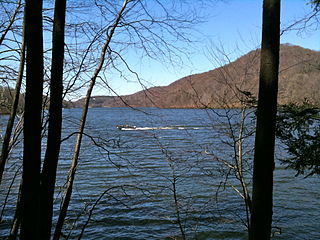
Lake Zoar is a reservoir on the Housatonic River in the U.S. state of Connecticut. It was formed by the completion of the Stevenson Dam, which flooded an area of Oxford and Stevenson named "Pleasantvale" or "Pleasant Vale". "Connecticut's Lakes Reflect Our History, Present". Retrieved 2018-04-02. The towns of Monroe, Newtown, Oxford, and Southbury border Lake Zoar. The name Zoar originates from corner of Newtown and Monroe that once called itself Zoar after the Biblical city Zoara near the Dead Sea.
References
- ↑ "Housatonic River". Archived from the original on 2010-08-28. Retrieved 2010-05-28.
- ↑ "Two Men, Dog, Rescued from Wooster Island | Valley Independent Sentinel".
- 1 2 "INTEGRATED WATER QUALITY REPORT" (PDF). State of Connecticut. 2008. Archived from the original (PDF) on 2011-07-21. Retrieved 2023-09-24.
- ↑ "2008 Waterbody Report for Lis Cb Inner - Housatonic River (Upper), Orange". Archived from the original on 2011-06-14. Retrieved 2010-05-28.
- ↑ "Wooster Island, Connecticut Latitude/Longitude".
- ↑ "Appendix C. 2006 List of Connecticut Waterbodies Not Meeting Water Quality Standards" (PDF). Archived from the original (PDF) on 2011-07-21. Retrieved 2023-09-24.
- ↑ "Sec. 15-121-B1. Requirements of application for number" (PDF). Archived from the original (PDF) on 2010-05-15. Retrieved 2023-09-24.