External links
- West River, planning map of City of New Haven
| | This Connecticut state location article is a stub. You can help Wikipedia by expanding it. |
West River is an official neighborhood of the city of New Haven, Connecticut. The neighborhood covers the part of the city east of the West River (boundary with the city of West Haven) and south of Chapel Street. Official planning maps run the eastern and southern boundaries run along Day Street, Legion Avenue, Winthrop Avenue, and Davenport Avenue. The neighborhood is bounded by the Edgewood (to the north), Dwight (north and east), and Hill (south) neighborhoods. The neighborhood includes West River Memorial Park and Evergreen Cemetery. The Hospital of St. Raphael is also included within the official neighborhood planning area.
| | This Connecticut state location article is a stub. You can help Wikipedia by expanding it. |
Long Wharf is a waterfront district and neighborhood of the city of New Haven, Connecticut, United States. The neighborhood is a mixed-use district, with a combination of commercial, industrial, port, and recreation facilities.

Mott Haven is a primarily residential neighborhood in the southwestern section of the New York City borough of the Bronx. Its boundaries, starting from the north and moving clockwise, are East 149th Street to the north, the Bruckner Expressway to the east, the Major Deegan Expressway to the south, and the Harlem River to the west. East 138th Street is the primary east–west thoroughfare through Mott Haven.

Westville is a neighborhood of the city of New Haven, Connecticut. It is consistently ranked as one of the best neighborhoods to live in New Haven due to its high home values, low crime rates, walkable streets, proximity to downtown, and local amenities.
The city of Minneapolis, Minnesota, United States is officially defined by the Minneapolis City Council as divided into eleven communities, each containing multiple official neighborhoods. Informally, there are city areas with colloquial labels. Residents may also group themselves by their city street suffixes, North, Northeast, South, Southeast, and Southwest.
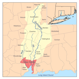
Fair Haven Heights, or simply the Heights, is a residential and light industrial neighborhood in the eastern part of the city of New Haven, Connecticut, located east of the Quinnipiac River. Fair Haven Heights is not to be confused with the adjacent Fair Haven neighborhood west of the river. The area is bordered on the west by the Quinnipiac River, on the north by Route 80, on the east by the town of East Haven, and on the south by Ferry Street and Warwick Avenue. The main through routes are Quinnipiac Avenue, East Grand Avenue, and Eastern Street
Quinnipiac Meadows, also known as Bishop Woods, is a neighborhood in the northeast corner of the city of New Haven, Connecticut located east of the Quinnipiac River and north of Fair Haven and Fair Haven Heights. It contains a considerable wetlands area which is a nature preserve. The area is bordered on the north by the town of North Haven, on the east by the town of East Haven, on the south by Route 80, on the southwest by Interstate 91, and on the west by the Amtrak railroad tracks. The portion of the area west of I-91 is also part of the community known as Cedar Hill.

Glenbrook is a section of the city of Stamford, Connecticut. It is located on the eastern side of the city, east of Downtown, north of the East Side and the Cove sections and south of the Springdale section. To the west is Downtown Stamford and to the northwest is Belltown. To the east is Darien.
Amity is a residential and commercial neighborhood of the city of New Haven, Connecticut, United States. It is bounded on the northeast by West Rock Ridge, on the south by the Westville neighborhood of New Haven, and on the northwest by the Flats in the town of Woodbridge, Connecticut. The official New Haven neighborhood planning maps include the traditionally separate neighborhoods of West Hills and Beverly Hills within the Amity neighborhood. The neighborhood lies in the glacier-carved valley of the West River. The river flows in a southerly direction, bisecting the neighborhood.
The West River is a 13.5-mile-long (21.7 km) freshwater stream in southern Connecticut. It flows through the towns of Bethany, Woodbridge, and New Haven before discharging into New Haven Harbor.
Mill River is a primarily industrial neighborhood in the city of New Haven, Connecticut located between the Wooster Square and Fair Haven neighborhoods.

Stuyvesant Square is the name of both a park and its surrounding neighborhood in the New York City borough of Manhattan. The park is located between 15th Street, 17th Street, Rutherford Place, and Nathan D. Perlman Place. Second Avenue divides the park into two halves, east and west, and each half is surrounded by the original cast-iron fence.
The West Bronx is a region in the New York City borough of the Bronx. The region lies west of the Bronx River and roughly corresponds to the western half of the borough.

Lenox Hill is a neighborhood on Manhattan's Upper East Side. It forms the lower section of the Upper East Side—east of Park Avenue in the 60s and 70s.
East Shore is a neighborhood in the city of New Haven, Connecticut. The East Shore contains the Morris Cove Historic District. Its name is derived from its geographic location on the east side of New Haven Harbor. It is bordered on the north by Upson Terrace and The Annex neighborhood, on the east by the town of East Haven, on the west and south by Long Island Sound. The area contains several city parks, most notably Lighthouse Point Park, East Shore Park, and Nathan Hale Park. Tweed-New Haven Airport is also located partly in the area. East Shore was originally part of the town of East Haven before being annexed by New Haven. The main thoroughfares of the neighborhood are Townsend Avenue and Woodward Avenue.
The Annex is a residential neighborhood in the city of New Haven, Connecticut. Originally part of East Haven, the neighborhood was voluntarily ceded by East Haven and annexed by the city of New Haven in the 1880s. It is located on the eastern side of New Haven Harbor across from Long Wharf. The City of New Haven defines the neighborhood to be the region bounded by Upson Terrace and East Shore Park on the south, the city of East Haven on the east, Warwick Street and East Ferry Street on the northeast, the Quinnipiac River on the northwest, and New Haven Harbor on the west.

Prospect Hill is a neighborhood of the city of New Haven, Connecticut located in the north central portion of the city, directly north of Downtown New Haven. The neighborhood contains residences, institutional buildings of Albertus Magnus University and a portion of the main campus of Yale University, including the Science Hill area, the Hillhouse Avenue area and the Yale Peabody Museum. The City of New Haven defines the neighborhood to be the region bounded by the town of Hamden in the north, Winchester Avenue in the west, Munson Street/Hillside Place/Prospect Street in the southwest, Trumbull Street in the south, and Whitney Avenue in the east. Prospect Street is the main thoroughfare through the neighborhood.

Western Avenue is one of three boundary streets between Washington, D.C., and the state of Maryland. It follows a southwest-to-northeast line, beginning at Westmoreland Circle in the south and ending at Oregon Avenue NW in the north. It is roughly 3.5 miles (5.6 km) in length. First proposed in 1893, it was constructed somewhat fitfully from about 1900 to 1931.
South Central is a neighborhood in Wichita, Kansas, United States. A mixed commercial and residential area on the east bank of the Arkansas River, it is among the city’s oldest neighborhoods.