The Hill, New Haven

Last updated
The Hill
Neighborhood of New Haven
Aerial closeup YNHH 2010.jpg
New Haven map - The Hill.png
location of The Hill within New Haven
Coordinates: 41°17′46″N72°56′13″W / 41.296°N 72.937°W / 41.296; -72.937 Coordinates: 41°17′46″N72°56′13″W / 41.296°N 72.937°W / 41.296; -72.937
Country United States
State Connecticut
City New Haven

The Hill is the southwesternmost neighborhood of New Haven, Connecticut. [1] As early as 1800, this area was known as "Sodom Hill". [2] Located directly south of Downtown New Haven, this neighborhood is home to residential areas, some light industry, New Haven Union Station as well as Yale-New Haven Hospital and the Yale School of Medicine.

Contents

History

Originally a distinct suburb of New Haven, The Hill began its urban development in the early 1800s. The sub-neighborhood south of Columbus Ave now known as Trowbridge Square was established in the 1830s by brothers Nathaniel and Simeon Jocelyn. Known at first as the village of Spireworth, this enclave was founded as a rare example of a racially integrated planned community. [3]

Oak Street, in a section of the Hill that was fully demolished to make way for the Oak Street Connector Oak Street, New Haven prior to demolition.jpg
Oak Street, in a section of the Hill that was fully demolished to make way for the Oak Street Connector

In the middle of the century, waves of Irish and German immigrants began pouring into the neighborhood. African-Americans migrated from the American South, and this neighborhood also served as a stop on the Underground Railroad. [3]

In 1957 a sizable swath of the Hill containing 881 households and 350 businesses was flattened to make way for the Oak Street Connector, a 1.1 mile highway stub that was never extended toward Derby as originally planned. [4] In 2013, New Haven began work to downgrade the Oak Street Connector into city streets in an effort to reconnect The Hill to Downtown New Haven.

The neighborhood includes a number of historic structures, including the former Ahavas Sholem Synagogue, the New Haven Jewish Home for the Aged, and the former Welch Training School, all on the National Register of Historic Places.

Geography

Houses along Trowbridge Square Trowbridge4.jpg
Houses along Trowbridge Square

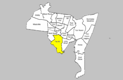
The Hill is bounded by the Route 34/Oak Street Connector and Legion Ave. at the north, the Long Wharf neighborhood at the east, the city of West Haven at the west, and Long Island Sound at the south. [5] The southeastern part of the neighborhood (south of Columbus Avenue) is roughly divided into three sections: Kimberly Square, Trowbridge Square, and City Point. This area south of Columbus Avenue originally was known as the Oyster Point Quarter, while the area north of Columbus Avenue was known as Sodom Hill. The Trowbridge Square section and the southern half of the City Point section are listed as historic districts on the National Register of Historic Places. City Point, which is located south of the railroad tracks, was traditionally a separate neighborhood but official neighborhood planning maps now include it in The Hill. The block formed by Redfield, West, Congress, and Columbus is also a state historic district known as Redfield & West Streets Historic District.

Columbus Avenue, Washington Avenue, and Howard Avenue are the three main arteries of the Hill. Between Washington Avenue and I-95, the area immediately fronting Howard Avenue has been designated as the Howard Avenue Historic District.

Economy

Welch Training School, on the National Register of Historic Places Welch Training School in New Haven, October 20, 2008.jpg
Welch Training School, on the National Register of Historic Places

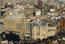
The Hill neighborhood contains the majority of buildings of Yale-New Haven Hospital and Yale Medical School. The expansion of this Medical campus area is a source of tension with the bordering residential areas. The residential areas of the Hill are mostly working-class and minority neighborhoods.

The Hill is also home to New Haven's main railroad station, Union Station, and some light-industrial businesses such as the Lupi-Legna Bakery. Public schools and libraries include Hill Regional Career High School, Betsy Ross Arts Magnet School, Roberto Clemente Leadership Academy and the Wilson Library.

Demographics

The ZIP code for the neighborhood is 06519. [5] As of 2010, the population of this ZIP code was 16,428 with an ethnic makeup of 50.5% Hispanic or Latino, 9.8% non-Hispanic white, 36.9% non-Hispanic African American, 0.7% Native American, 1.2% Asian, 0.1% Pacific Islander, 0.1% non-Hispanic from some other race and 3.6% from two or more races. [6]

Related Research Articles

New Haven, Connecticut City in Connecticut, United States

New Haven is a coastal city in the U.S. state of Connecticut. It is located on New Haven Harbor on the northern shore of Long Island Sound in New Haven County, Connecticut, and is part of the New York City metropolitan area. With a population of 134,023 as determined by the 2020 United States Census, New Haven is now the third-largest city in Connecticut after Bridgeport, and Stamford. New Haven is the principal municipality of Greater New Haven, which had a total population of 864,835 as of 2020.

Wooster Square Neighborhood of New Haven in Connecticut, United States

Wooster Square is a neighborhood in the city of New Haven, Connecticut to the east of downtown. The name refers to a park square located between Greene Street, Wooster Place, Chapel Street and Academy Street in the center of the neighborhood. Wooster Square is also known as Little Italy: a bastion of Italian American culture and cuisine, and is home to some of New Haven's, best-known pizza eateries, including Frank Pepe Pizzeria Napoletana and Sally's Apizza. The square and much of the neighborhood are included in the Wooster Square Historic District, which was listed on the National Register of Historic Places in 1971.

Downtown New Haven Neighborhood of New Haven in Connecticut, United States

Downtown New Haven is the neighborhood located in the heart of the city of New Haven, Connecticut. It is made up of the original nine squares laid out in 1638 to form New Haven, including the New Haven Green, and the immediate surrounding central business district, as well as a significant portion of the Yale University campus. The area includes many restaurants, cafes, theaters and stores. Downtown is bordered by Wooster Square to the east, Long Wharf to the southeast, the Hill neighborhood to the south, the Dwight neighborhood to the west, the Dixwell neighborhood to the northwest, the Prospect Hill area to the north, and East Rock to the northeast.

Westville, New Haven Neighborhood of New Haven in Connecticut, United States

Westville is a neighborhood of the city of New Haven, Connecticut. It is consistently ranked as one of the best neighborhoods to live in New Haven due to its high home values, low crime rates, walkable streets, proximity to downtown, and local amenities.

Downtown Brooklyn Place in New York, United States

Downtown Brooklyn is the third largest central business district in New York City, United States, and is located in the northwestern section of the borough of Brooklyn. The neighborhood is known for its office and residential buildings, such as the Williamsburgh Savings Bank Tower and the MetroTech Center office complex.

East Rock, New Haven Neighborhood of New Haven in Connecticut, United States

East Rock is a neighborhood in the city of New Haven, Connecticut, named for nearby East Rock, a prominent trap rock ridge. The area is home to a large group of Yale students, staff, and faculty, as well as many young professionals and families. East Rock is also a popular destination for cyclists, as a city bike lane runs along Orange Street, the neighborhood's spine.

City Point, New Haven United States historic place

City Point is an area in what is now The Hill neighborhood of the city of New Haven, Connecticut, located in the southwestern portion of the city. The City Point area was, when settled and through the 18th century, a relatively narrow peninsula extending south into New Haven Harbor, located where the West River empties into the harbor. Areas adjacent to the original peninsula have since been filled in, broadening its shoulders, and Interstate 95 has cut across it. The Oyster Point Historic District is a 26-acre (11 ha) historic district encompassing an area of relatively old buildings in City Point south of I-95.

Midtown Memphis, Tennessee is a collection of neighborhoods to the east of Downtown.

Port Morris, Bronx Neighborhood of the Bronx in New York City

Port Morris is a mixed use, primarily industrial neighborhood geographically located in the southwest Bronx, New York City. The neighborhood is part of Bronx Community Board 1. Its boundaries are the Major Deegan Expressway and Bruckner Expressway to the north, East 149th Street to the east, the East River to the southeast, the Bronx Kill to the south, and the Harlem River to the west. Its ZIP Code is 10454 and 10451. The neighborhood is served by the NYPD's 40th Precinct.

The Near East Side is a neighborhood located near downtown Columbus, Ohio, made up of several neighborhoods: Mount Vernon, King-Lincoln Bronzeville, Eastgate, Franklin Park, Nelson Park, Olde Towne East, and Woodland Park.

Columbus, the state capital and Ohio's largest city, has numerous neighborhoods within its city limits. Neighborhood names and boundaries are not officially defined. They may vary or change from time to time due to demographic and economic variables.

Neighborhoods of Hartford, Connecticut

The neighborhoods of Hartford, Connecticut in the United States are varied and historic.

Driving Park Neighborhood in Columbus, Ohio, U.S.

Driving Park is an urban residential area on the Near East Side of Columbus, Ohio just south of Interstate 70. Mainly a middle-class, predominantly African American neighborhood, Driving Park and its surrounding neighborhoods consist of an area of 17,730 residents. Driving Park received its name from its historic past as a large racing complex, first for horses and later for automobiles.

The city of San Antonio in the U.S. state of Texas is composed of a number of neighborhoods and districts, spreading out surrounding the central Downtown Area.

Neighborhoods of Norwich, Connecticut

Several neighborhoods of Norwich, Connecticut maintain independent identities and are recognized by official signs marking their boundaries. The following is a list of neighborhoods in Norwich.

Prospect Hill, New Haven

Prospect Hill is a neighborhood of the city of New Haven, Connecticut located in the north central portion of the city, directly north of Downtown New Haven. The neighborhood contains residences, institutional buildings of Albertus Magnus University and a portion of the main campus of Yale University, including the Science Hill area, the Hillhouse Avenue area and the Yale Peabody Museum. The City of New Haven defines the neighborhood to be the region bounded by the town of Hamden in the north, Winchester Avenue in the west, Munson Street/Hillside Place/Prospect Street in the southwest, Trumbull Street in the south, and Whitney Avenue in the east. Prospect Street is the main thoroughfare through the neighborhood.

The city of New Haven, Connecticut has many distinct neighborhoods. In addition to Downtown, centered on the central business district and the Green, are the following neighborhoods: the west central neighborhoods of Dixwell and Dwight; the southern neighborhoods of The Hill, historic water-front City Point, and the harborside district of Long Wharf; the western neighborhoods of Edgewood, West River, Westville, Amity, and West Rock; East Rock, Cedar Hill, Prospect Hill, and Newhallville in the northern side of town; the east central neighborhoods of Mill River and Wooster Square, an Italian-American neighborhood; Fair Haven, an immigrant community located between the Mill and Quinnipiac rivers; Quinnipiac Meadows and Fair Haven Heights across the Quinnipiac River; and facing the eastern side of the harbor, The Annex and East Shore.

Trowbridge Square Historic District United States historic place

Trowbridge Square Historic District, originally known as Village of Spireworth and Mount Pleasant, is a well-preserved 19th-century neighborhood in the Hill section New Haven, Connecticut. Roughly bounded by Columbus, Howard, and Union Avenues, and Church Street on the east, the area was laid out in 1830 and developed as a working-class neighborhood. It retains its historic streetscape, and many original buildings, representing modest versions of a diversity of mid-to-late 19th century styles. The district was listed on the National Register of Historic Places in 1985.

Franklin Park (Columbus, Ohio) Place

Franklin Park is a neighborhood located on the Near East Side of Columbus, Ohio. Both the historic neighborhood and landmark, the Franklin Park Conservatory and Botanical Gardens, are named after the 88-acre park.

References

  1. Hill (PDF) (Map). New Haven City Plan Department. Retrieved 2009-02-06.
  2. E. M. Brown, New Haven: A guide to architecture and urban design, Yale University Press, 1976.
  3. 1 2 "Old as 'The Hill:' New Haven neighborhood's history on display at museum (video)".
  4. Gibbons, Lauren. "The Yale Herald".
  5. 1 2 Hello New Haven
  6. 2010 census report for 06519 zip code