Related Research Articles

The New Haven Green is a 16-acre (65,000 m2) privately owned park and recreation area located in the downtown district of the city of New Haven, Connecticut, United States. It comprises the central square of the nine-square settlement plan of the original Puritan colonists in New Haven, and was designed and surveyed by colonist John Brockett. Today the Green is bordered by the modern paved roads of College, Chapel, Church, and Elm streets. Temple Street bisects the Green into upper (northwest) and lower (southeast) halves.
Fieldston is a privately owned affluent neighborhood in the Riverdale section of the northwestern part of the New York City borough of the Bronx. It is bounded by Manhattan College Parkway to the south, Henry Hudson Parkway to the west, 250th Street to the north, and Broadway to the east. It is noted for its rural atmosphere, large houses and abundance of trees. The majority of the neighborhood is included in the Fieldston Historic District, designated by the New York City Landmarks Preservation Commission in 2006.
Prospect Park South is a small neighborhood in Flatbush, Brooklyn, New York City, located south of Prospect Park. It is included within the Prospect Park South Historic District, which was designated by the New York City Landmarks Preservation Commission in 1979 and listed on the National Register of Historic Places in 1983. The historic district is bounded by Church Avenue to the north, the BMT Brighton Line of the New York City Subway to the east, Beverley Road to the south, and between Stratford Road and Coney Island Avenue to the west.
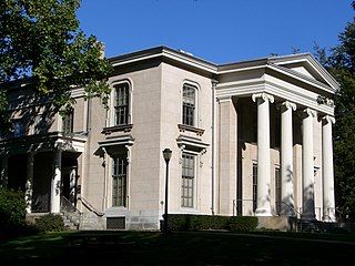
Hillhouse Avenue is a street in New Haven, Connecticut, famous for its many nineteenth century mansions, including the president's house at Yale University. Both Charles Dickens and Mark Twain have described it as "the most beautiful street in America." Much of the avenue is included in the Hillhouse Avenue Historic District, which extends to include houses on adjacent streets.

Heritage Hill is a residential neighborhood in Grand Rapids, Michigan. It is listed on the National Register of Historic Places and is one of the largest urban historic districts in the United States. It is bounded by Crescent Street (north), Union Avenue (east), Pleasant Street (south), and Lafayette Avenue (west). Heritage Hill was designated by the American Planning Association as one of 2012's Great Places in America.

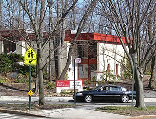
Edgewood Historic District is a historic district located in the west-central portion of New Haven, Connecticut. It was listed on the National Register of Historic Places in 1986. A predominantly residential area roughly bisected by Edgewood Avenue, a broad boulevard which features a large central esplanade and forms the principal east-west artery through the heart of the district. The area includes 232 contributing buildings, 4 other contributing structures, and 1 contributing object. Most of these were built between about 1888 and 1900, and represent the city's first neighborhood planned under the tenets of the City Beautiful movement. They are generally either Queen Anne or Colonial Revival in style, and are set on larger lots.
Prospect Hill is a neighborhood of the city of New Haven, Connecticut located in the north central portion of the city, directly north of Downtown New Haven. The neighborhood contains residences, institutional buildings of Albertus Magnus College and a portion of the main campus of Yale University, including the Science Hill area, the Hillhouse Avenue area and the Yale Peabody Museum. The City of New Haven defines the neighborhood to be the region bounded by the town of Hamden in the north, Winchester Avenue in the west, Munson Street/Hillside Place/Prospect Street in the southwest, Trumbull Street in the south, and Whitney Avenue in the east. Prospect Street is the main thoroughfare through the neighborhood.
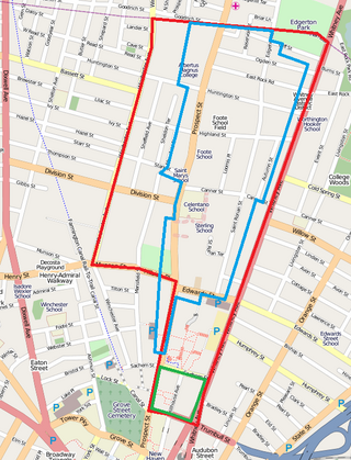
The Prospect Hill Historic District is an irregularly-shaped 185-acre (75 ha) historic district in New Haven, Connecticut. The district encompasses most of the residential portion of the Prospect Hill neighborhood.

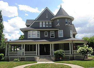
The Whitney Avenue Historic District is a historic district in the East Rock neighborhood of New Haven, Connecticut. It is a 203-acre (82 ha) district which included 1,084 contributing buildings when it was listed on the National Register of Historic Places in 1989.

The Winchester Repeating Arms Company Historic District is a historic district in New Haven, Connecticut that was listed on the National Register of Historic Places in 1988. It includes 867 properties, which "include 858 major structures and 131 notable outbuildings." Of these structures, 876 are buildings deemed to contribute to the historical and/or architectural significance of the area, and most of these are residential. However the center of the district is "dominated" by the 75-acre (30 ha) tract of the former Winchester Repeating Arms Company, which contains industrial buildings.

This is a list of National Register of Historic Places listings in New Haven, Connecticut.

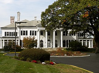
The Beaver Hills Historic District is a 97-acre (39 ha) historic district in the Beaver Hills neighborhood of New Haven, Connecticut. It was listed on the National Register of Historic Places in 1986. In 1986, it included 235 contributing buildings.

Newington Junction is a section of the town of Newington, Connecticut, United States. It is centered at the intersection of Willard Avenue and West Hill Road in the northwestern part of the town, in the area generally just south of the Hartford city line. The name of the area refers to the railroad junction where the railroad line from New Haven meets with the railroad line from Bristol and Waterbury. The development of Newington Junction as a result of the railroad was instrumental in the separation of the town of Newington from its mother town of Wethersfield.
The city of New Haven, Connecticut has many distinct neighborhoods. In addition to Downtown, centered on the central business district and the Green, are the following neighborhoods: the west central neighborhoods of Dixwell and Dwight; the southern neighborhoods of The Hill, historic water-front City Point, and the harborside district of Long Wharf; the western neighborhoods of Edgewood, West River, Westville, Amity, and West Rock; East Rock, Cedar Hill, Prospect Hill, and Newhallville in the northern side of town; the east central neighborhoods of Mill River and Wooster Square, an Italian-American neighborhood; Fair Haven, an immigrant community located between the Mill and Quinnipiac rivers; Quinnipiac Meadows and Fair Haven Heights across the Quinnipiac River; and facing the eastern side of the harbor, The Annex and East Shore.
Fairlawn–Nettleton Historic District is a state-designated historic district in New Haven, Connecticut.

The Vinegar Hill Historic District is a historic district and neighborhood in Bloomington, Indiana, United States. Built primarily in the second quarter of the twentieth century, and located a few blocks south of Indiana University Bloomington campus, Vinegar Hill has been the home of leading Indiana University faculty members. It has inspired literary attention, and it has been designated a historic site.

Oliver Johnson's Woods is a historic district and neighborhood on the northern side of Indianapolis, Indiana, United States. Located in southern Washington Township, the district occupies the site of what was once the family farm of Oliver Johnson. Born on the present site of the Indiana State Fairgrounds, Johnson grew up in a pioneer family that lived on the edge of the state capital city. Upon attaining adulthood, he bought property a short distance to the west, to which he moved in 1846. Here, he built a larger farmhouse in 1862, and he tilled the soil for most of the rest of his life. As Indianapolis grew northward, it reached the Johnson farm in the early twentieth century; the aged farmer and his sons saw the city's growth as an opportunity for financial gain, and in 1905 they announced the platting of 0.25 square miles (0.65 km2) of their property into individual lots. They chose an advantageous time to sell their property; as the new residents began to build their homes, an interurban railway was built along College Avenue on the district's western side that connected downtown with Broad Ripple. Many prosperous businessmen were attracted by the development's large lots and wooded streets; the city annexed Oliver Johnson's Woods in 1912, and by the outbreak of World War II, the streets were filled with large houses built in a wide variety of architectural styles. These early residents came from many different ethnicities: European immigrants were becoming more prosperous and leaving their ethnic enclaves, and new neighborhoods such as Oliver Johnson's Woods appealed to them. Among the neighborhood's leading residents was a colony of Jews of German descent.

Peachtree Park is a neighborhood in the Buckhead Community of Atlanta, Georgia.
White City is a residential neighborhood in Midtown, Tulsa, Oklahoma. It is bounded on the north by 2nd Street, on the east by Fulton Avenue, on the south by 11th Street and on the west by Yale Avenue. The neighborhood was added to the National Register of Historic Places in 2001. The area includes 480 buildings, of which 325 retain their historic significance. Two parks are also included in the listing.
Beaver Street is a street in the Financial District of Lower Manhattan in New York City. Beaver Street runs five blocks from Pearl Street in the east to Broadway in the west. Along its length, it crosses Hanover, William, Broad, and New Streets. The street is preserved as part of the New Amsterdam street grid, a New York City designated landmark.
References
- ↑ Beaver Hills Historic District Archived 2010-03-10 at the Wayback Machine , New Haven Preservation Trust website
- ↑ James Dwight Dana (1870), Geology of the New Haven Region: With Special Reference to the Origin of its Topographical Features, Tuttle, Morehouse & Taylor
- ↑ "National Register Information System". National Register of Historic Places . National Park Service. March 13, 2009.
- 1 2 J. Paul Loether and John Herzan (January 14, 1986). "National Register of Historic Places Inventory-Nomination: Beaver Hills Historic District". National Park Service. and Accompanying 27 photos, from 1984, 1986