Mill River, New Haven

Last updated

Coordinates: 41°18′25″N72°54′36″W / 41.307°N 72.910°W / 41.307; -72.910

Geographic coordinate system Coordinate system

A geographic coordinate system is a coordinate system that enables every location on Earth to be specified by a set of numbers, letters or symbols. The coordinates are often chosen such that one of the numbers represents a vertical position and two or three of the numbers represent a horizontal position; alternatively, a geographic position may be expressed in a combined three-dimensional Cartesian vector. A common choice of coordinates is latitude, longitude and elevation. To specify a location on a plane requires a map projection.

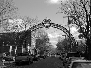
Mill River is a primarily industrial neighborhood in the city of New Haven, Connecticut located between the Wooster Square and Fair Haven neighborhoods. [1]

Neighbourhood geographically localized community within a larger city, town, suburb or rural area

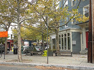
A neighbourhood, or neighborhood, is a geographically localised community within a larger city, town, suburb or rural area. Neighbourhoods are often social communities with considerable face-to-face interaction among members. Researchers have not agreed on an exact definition, but the following may serve as a starting point: "Neighbourhood is generally defined spatially as a specific geographic area and functionally as a set of social networks. Neighbourhoods, then, are the spatial units in which face-to-face social interactions occur—the personal settings and situations where residents seek to realise common values, socialise youth, and maintain effective social control."

New Haven, Connecticut City in Connecticut, United States

New Haven is a coastal city in the U.S. state of Connecticut. It is located on New Haven Harbor on the northern shore of Long Island Sound in New Haven County, Connecticut, and is part of the New York metropolitan area. With a population of 129,779 as determined by the 2010 United States Census, it is the second-largest city in Connecticut after Bridgeport. New Haven is the principal municipality of Greater New Haven, which had a total population of 862,477 in 2010.

Connecticut state of the United States of America

Connecticut is the southernmost state in the New England region of the United States. As of the 2010 Census, it has the highest per-capita income, Human Development Index (0.962), and median household income in the United States. It is bordered by Rhode Island to the east, Massachusetts to the north, New York to the west, and Long Island Sound to the south. Its capital is Hartford and its most populous city is Bridgeport. It is part of New England, although portions of it are often grouped with New York and New Jersey as the Tri-state area. The state is named for the Connecticut River which approximately bisects the state. The word "Connecticut" is derived from various anglicized spellings of an Algonquian word for "long tidal river".

The area is bordered on the east by the Mill River (from I-95 up to the vicinity of Humphrey Street) then by Amtrak railroad tracks (up to Blatchley Avenue). It is bordered on the west and northwest by Interstate 91 (between Exits 2 and 6), and on the south by Interstate 95. There are two clusters of residential areas in the neighborhood, Farnam Courts, [2] [3] which are low cost apartments managed by the Housing Authority of New Haven, and the area around Jocelyn Square, which was traditionally part of the Upper State Street neighborhood. The northeastern corner of the area east of the river between I-91 (from Exit 5 to 6) and the railroad tracks, where the garage for Connecticut Transit New Haven is located, is also considered to be part of the community known as Cedar Hill. Hamilton Street and East Street are the main north–south thoroughfares, while Humphrey Street, Grand Avenue, and Chapel Street serve as east–west through routes.

Amtrak Intercity rail operator in the United States

The National Railroad Passenger Corporation, doing business as Amtrak, is a passenger railroad service that provides medium- and long-distance intercity service in the contiguous United States and to nine Canadian cities.

Interstate 91 (I-91) is an Interstate Highway in the New England region of the United States. It provides the primary north–south thoroughfare in the western part of the region. The Interstate's southern end is in New Haven, Connecticut, at Interstate 95 and its northern end is at Derby Line, Vermont, a village in the town of Derby at the Canadian border, where it continues past the Derby Line-Rock Island Border Crossing as Autoroute 55. I-91 is the longest of three Interstate highways whose entire route is located within the New England states and is also the only primary (two-digit) Interstate Highway in New England to intersect all five of the others that run through the region. The largest cities along its route are New Haven, Connecticut, Hartford, Connecticut, Springfield, Massachusetts, Brattleboro, Vermont, White River Junction, Vermont, and St. Johnsbury, Vermont in order from south to north.

Connecticut Transit New Haven

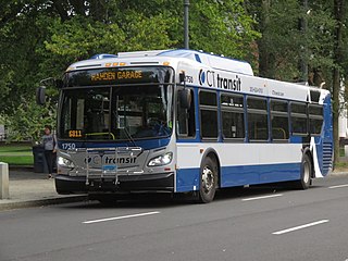
Connecticut Transit New Haven is the second largest division of Connecticut Transit, providing service on 24 routes in 19 towns within the Greater New Haven and Lower Naugatuck River Valley areas, with connections to other CT Transit routes in Waterbury and Meriden, as well as connections to systems in Milford and Bridgeport at the Connecticut Post Mall.

English Station, an abandoned power plant, is located on Ball Island in Mill River.

English Station

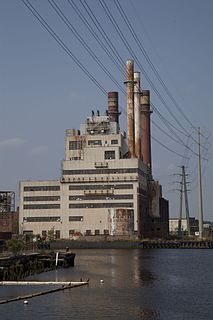
English Station is an abandoned thermal power plant. It occupies eight acres of land on Ball Island in the Mill River, Connecticut. It was constructed from 1924 to 1929. The plant operated as a coal- and oil-fired power plant for United Illuminating until it stopped electricity-generating operations in 1991.

See also

Related Research Articles

Schuylkill Haven, Pennsylvania Borough in Pennsylvania, United States

Schuylkill Haven is a borough in Schuylkill County, Pennsylvania, four miles (6 km) south of Pottsville and 89 miles (143 km) north-west of Philadelphia, in the United States. The borough's population was 5,548 as of the 2000 census. Schuylkill Haven is situated along the Schuylkill River for which it is named. Schuylkill Haven is a focal point of activity in southern Schuylkill County.

U.S. Route 5 highway in the United States

U.S. Route 5 is a north–south United States highway running through the New England states of Connecticut, Massachusetts, and Vermont. Significant cities along the route include New Haven, Connecticut; Hartford, Connecticut; and Springfield, Massachusetts. From Hartford northward to St. Johnsbury, Vermont, the road closely follows the route of the Connecticut River.

Wooster Square Neighborhood of New Haven in Connecticut, United States

Wooster Square is a neighborhood in the city of New Haven, Connecticut to the east of downtown. The name refers to a park square located between Greene Street, Wooster Place, Chapel Street and Academy Street in the center of the neighborhood. Wooster Square is also known as Little Italy: a bastion of Italian American culture and cuisine, and is home to some of New Haven's, best-known pizza eateries, including Frank Pepe Pizzeria Napoletana and Sally's Apizza. The square and much of the neighborhood are included in the Wooster Square Historic District, which was listed on the National Register of Historic Places in 1971.

Long Wharf is a waterfront district and neighborhood of the city of New Haven, Connecticut, United States.

Fair Haven, New Haven Neighborhood of New Haven in Connecticut, United States

Fair Haven is a neighborhood in the eastern part of the city of New Haven, Connecticut, between the Mill and Quinnipiac rivers. The northeast section of the neighborhood is also known as Chatham Square.

East Rock, New Haven Neighborhood of New Haven in Connecticut, United States

East Rock is a neighborhood in the city of New Haven, Connecticut, named for nearby East Rock, a prominent trap rock ridge. The area is home to a large group of Yale students, staff, and faculty, as well as many young professionals and families. It is known as the "grad ghetto," because it is a popular apartment rental location for graduate and professional students at Yale. East Rock is also a popular destination for cyclists, as a city bike lane runs along Orange Street, the neighborhood's spine.

Quinnipiac Meadows, also known as Bishop Woods, is a neighborhood in the northeast corner of the city of New Haven, Connecticut located east of the Quinnipiac River and north of Fair Haven and Fair Haven Heights. It contains a considerable wetlands area which is a nature preserve. The area is bordered on the north by the town of North Haven, on the east by the town of East Haven, on the south by Route 80, on the southwest by Interstate 91, and on the west by the Amtrak railroad tracks. The portion of the area west of I-91 is also part of the community known as Cedar Hill.

Connecticut Route 80 highway in Connecticut

Connecticut Route 80 is a 25.9 mile highway that runs through south-central Connecticut. The west end is at CT 17 in Quinnipiac Meadows neighborhood of New Haven, and the east end is at CT 154 in Deep River. Route 80 runs within 5 miles of many town squares- including Downtown New Haven.

Connecticut Route 40 highway in Connecticut

Route 40, also known as the Mount Carmel Connector, is a 3.08-mile (4.96 km) spur route from Interstate 91 in North Haven, Connecticut connecting I-91 and Bailey Road in North Haven to Route 10 in the Mount Carmel neighborhood of Hamden. Route 40 is a 4-lane freeway with one intermediate exit leading to / from U.S. Route 5 in North Haven. It crosses over Route 15 but does not have an interchange with it. This is the only place in the state where two freeways cross without an interchange.

Interstate 95 (I-95) is the main north–south Interstate Highway on the East Coast of the United States, running in a general east–west compass direction for 111.57 miles (179.55 km) in Connecticut, from the New York state line to the Rhode Island state line. I-95 from Greenwich to East Lyme is part of the Connecticut Turnpike, during which it passes through the major cities of Stamford, Bridgeport, and New Haven. After leaving the turnpike in East Lyme, I-95 is known as the Jewish War Veterans Memorial Highway and passes through New London, Groton, and Mystic, before exiting the state at the Rhode Island border.

Connecticut Route 122 highway in Connecticut

Route 122 is a primary, minor arterial highway in the United States. It begins at Interstate 95 in West Haven, Connecticut. It runs north of West Haven center and roughly follows the path of the West River. It then enters the Westville neighborhood of New Haven and ends at Route 63. Route 122 is 3.51 miles (5.65 km) long.


The valley of Amity is an area located partly in the towns of Woodbridge, Bethany, and Orange, Connecticut and partly in the city of New Haven. It is bounded on the northeast by the West Rock ridge, on the south by the Westville neighborhood of New Haven, and on the northwest by an incline in elevation above which lies the highlands of Woodbridge, Connecticut. The official New Haven neighborhood planning maps include the traditionally separate neighborhoods of West Hills and Beverly Hills within the Amity neighborhood.

Cedar Hill (New Haven) human settlement in Connecticut, United States of America

Cedar Hill is a neighborhood in New Haven, Connecticut. It includes portions of the city-designated neighborhoods of East Rock, Quinnipiac Meadows, and Mill River.

U.S. Route 5 in Connecticut highway in Connecticut

U.S. Route 5, a north–south U.S. Highway that is generally paralleled by Interstate 91, begins at the city of New Haven in Connecticut and heads north through western Massachusetts and eastern Vermont to the international border with Canada. Within Connecticut, US 5 proceeds north from New Haven and passes through Meriden and Hartford towards Springfield, Massachusetts.

Twenty-four business routes of Interstate 15 exist. Former routes also exist.

West River is an official neighborhood of the city of New Haven, Connecticut. The neighborhood covers the part of the city east of the West River and south of Chapel Street. Official planning maps run the eastern and southern boundaries run along Day Street, Legion Avenue, Winthrop Avenue, and Davenport Avenue. The neighborhood includes West River Memorial Park and Evergreen Cemetery. The Hospital of St. Raphael is also included within the official neighborhood planning area.

Upper State Street Historic District

The Upper State Street Historic District encompasses a well-preserved neighborhood commercial district of the late 19th century in the East Rock neighborhood of New Haven, Connecticut. The district is an irregular strip running NNE to SSW mainly along State Street in New Haven, one block west of Interstate 91, the highway which determines the district's eastern and southern borders. The district was listed on the U.S. National Register of Historic Places in 1984.

Ingleside, Holyoke, Massachusetts Neighborhood of Holyoke in Massachusetts, United States

Ingleside is a neighborhood in Holyoke, Massachusetts located to the south of the city center, approximately 2 miles from downtown. The neighborhood features access to the Connecticut River through the Sue Ellen Panitch River Center and the Land of Providence reservation. Ingleside is also home to the Holyoke Mall, the Nuestras Raices farm, the Sisters of Providence of Holyoke, the Providence Behavioral Health Hospital, and several recreational and historical venues.

References

  1. Mill River (PDF) (Map). New Haven City Plan Department. Retrieved 2009-02-06.
  2. https://www.loc.gov/pictures/item/gsc1994018890/PP/?sid=80507d862903e877185c58de50005ad2 Photos of Farnam Courts when they were first built.
  3. https://www.loc.gov/pictures/item/gsc1994021784/PP/?sid=74caff2ce68eedde826135a14f52393d Some more old photos of Farnum court