Essex Village, Connecticut

Last updated
Essex Village, Connecticut
Main Street, Essex CT.jpg
Main Street
USA Connecticut location map.svg
Red pog.svg
Essex Village
Usa edcp location map.svg
Red pog.svg
Essex Village
Coordinates: 41°21′12″N72°23′27″W / 41.35333°N 72.39083°W / 41.35333; -72.39083 Coordinates: 41°21′12″N72°23′27″W / 41.35333°N 72.39083°W / 41.35333; -72.39083
Country Flag of the United States.svg  United States
State Connecticut
County Middlesex
Town Essex
Area
[1]
  Total13.4 km2 (5.16 sq mi)
  Land9.9 km2 (3.84 sq mi)
  Water3.4 km2 (1.32 sq mi)
Elevation
[2]
10 m (40 ft)
Population
 (2020) [3]
  Total2,583
  Density672.5/km2 (1,742/sq mi)
Time zone UTC-5 (Eastern (EST))
  Summer (DST) UTC-4 (EDT)
ZIP Code
06426 (Essex)
Area code(s) 860/959
FIPS code 09-26370
GNIS feature ID2377820 [2]

Essex Village is a village and census-designated place (CDP) in the town of Essex, Connecticut, in the United States. The population was 2,583 at the 2020 census, [3] out of 6,733 in the entire town of Essex. The government offices of the town are located within the village.

Contents

Geography

The village is located in the eastern part of the town, along the banks of the Connecticut River. The census-designated place extends from the border of the town of Old Saybrook in the south to the Deep River town line in the north. The western edge of the CDP runs from north to south along the border of the Canfield-Meadow Woods Nature Preserve; Dennison Road; small portions of the Falls River and Connecticut Routes 154 and 621; the Mud River; the Connecticut Valley Railroad; and Bokum Road. [4] The Route 9 expressway passes through the western part of the CDP, with access from Exit 3.

According to the United States Census Bureau, the CDP has a total area of 5.16 square miles (13.4 km2), of which 3.84 square miles (9.9 km2) are land and 1.32 square miles (3.4 km2), or 25.58%, are water. [1]

Demographics

As of the census [5] of 2000, there were 2,573 people, 1,190 households, and 727 families residing in the CDP. The population density was 734.9 inhabitants per square mile (283.7/km2). There were 1,286 housing units at an average density of 367.3 per square mile (141.8/km2). The racial makeup of the CDP was 98.29% White, 0.43% African American, 0.08% Native American, 0.51% Asian, 0.12% from other races, and 0.58% from two or more races. Hispanic or Latino of any race were 0.93% of the population.

There were 1,190 households, out of which 21.1% had children under the age of 18 living with them, 55.0% were married couples living together, 4.8% had a female householder with no husband present, and 38.9% were non-families. 34.3% of all households were made up of individuals, and 14.6% had someone living alone who was 65 years of age or older. The average household size was 2.11 and the average family size was 2.71.

In the CDP, the population was spread out, with 18.0% under the age of 18, 2.9% from 18 to 24, 22.7% from 25 to 44, 34.4% from 45 to 64, and 22.0% who were 65 years of age or older. The median age was 49 years. For every 100 females, there were 91.9 males. For every 100 females age 18 and over, there were 88.7 males.

The median income for a household in the CDP was $78,763, and the median income for a family was $109,276. Males had a median income of $68,281 versus $52,889 for females. The per capita income for the CDP was $51,928. About 1.3% of families and 3.5% of the population were below the poverty line, including 2.9% of those under age 18 and 1.3% of those age 65 or over.

Related Research Articles

Tariffville is a neighborhood and census-designated place (CDP) in the town of Simsbury in Hartford County, Connecticut, United States. The population was 1,324 at the 2010 census. It is a popular location for whitewater paddlers who use the Farmington River.

<span class="mw-page-title-main">Terramuggus, Connecticut</span> Census-designated place in Connecticut, United States

Terramuggus is a census-designated place (CDP) in the town of Marlborough, Hartford County, Connecticut, United States. It contains the town center village and surrounding areas. The population was 1,025 at the 2010 census.

<span class="mw-page-title-main">Thompsonville, Connecticut</span> Census-designated place in Connecticut, United States

Thompsonville is a census-designated place (CDP) in the town of Enfield in Hartford County, Connecticut, United States. The population of the CDP was 8,577 at the 2010 census.

<span class="mw-page-title-main">Oakville, Connecticut</span> Census-designated place in Connecticut, United States

Oakville is a census-designated place (CDP) and neighborhood section of Watertown, in Litchfield County, Connecticut, United States. The population was 9,047 as of the 2010 census. It is the most populous community in Watertown, with more than twice as many people as the center village of Watertown. The ZIP code for Oakville is 06779.

<span class="mw-page-title-main">Deep River, Connecticut</span> Town in Connecticut, United States

Deep River is a town in Middlesex County, Connecticut. The population was 4,415 at the 2020 census. The town center is designated by the U.S. Census Bureau as a census-designated place (CDP). Deep River is part of what the locals call the "Tri-town Area", made up of the towns of Deep River, Chester, and Essex.

Old Saybrook Center is the primary village and a census-designated place (CDP) in the town of Old Saybrook, Middlesex County, Connecticut, United States. The population was 2,278 at the 2020 census, out of 10,481 in the entire town of Old Saybrook. The CDP includes the traditional town center and the peninsula known as Saybrook Point.

<span class="mw-page-title-main">Westbrook, Connecticut</span> Town in Connecticut, United States

Westbrook is a town in Middlesex County, Connecticut, United States. The population was 6,769 at the 2020 census. The town center is classified by the U.S. Census Bureau as a census-designated place (CDP).

<span class="mw-page-title-main">Poquonock Bridge, Connecticut</span> Census-designated place in Connecticut, United States

Poquonnock Bridge is a village and census-designated place (CDP) in the town of Groton in New London County, Connecticut, United States. The population was 1,727 at the 2010 census.

<span class="mw-page-title-main">Somers, Connecticut</span> Town in Connecticut, United States

Somers is a town in Tolland County, Connecticut. The population was 10,255 at the 2020 census. The town center is listed by the U.S. Census Bureau as a census-designated place (CDP). In 2007, Money Magazine listed Somers 53rd on its "100 Best Places to Live", based on "economic opportunity, good schools, safe streets, things to do and a real sense of community."

<span class="mw-page-title-main">Plainfield Village, Connecticut</span> Village in Connecticut, United States

Plainfield Village is a village and census-designated place (CDP) in the town of Plainfield, Connecticut in the United States. The population was 2,557 at the 2010 census. It is located in the southwest part of town, in the area west of I-395 and south of Route 14. The village is also the core of the Plainfield, CT urban cluster.

<span class="mw-page-title-main">Putnam (CDP), Connecticut</span> Census-designated place in Connecticut, United States

Putnam District is a village and census-designated place (CDP) in Windham County, Connecticut, United States. The CDP was formed when the former city of Putnam disincorporated, and it consists of the main town center of the town of Putnam along the Quinebaug River. The population was 7,214 at the 2010 census.

<span class="mw-page-title-main">Bloomfield, Vermont</span> Town in Vermont, United States

Bloomfield is a town in Essex County, Vermont, United States. The population was 217 at the 2020 census. It is part of the Berlin, NH–VT Micropolitan Statistical Area.

<span class="mw-page-title-main">Brunswick, Vermont</span> Town in Vermont, United States

Brunswick is a town in Essex County, Vermont, United States. The town was named after Prince Karl Wilhelm Ferdinand of Brunswick-Lunenburg. The population was 88 at the 2020 census. It is part of the Berlin, NH–VT Micropolitan Statistical Area. Brunswick is home to six mineral springs that made the town a popular resort destination in the 19th century. The land the springs are on is now owned by the Abenaki people.

<span class="mw-page-title-main">Lemington, Vermont</span> Town in Vermont, United States

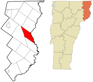
Lemington is a town in Essex County, Vermont, United States. The population was 87 as of the 2020 census. It is part of the Berlin, NH–VT Micropolitan Statistical Area.

Lancaster is a census-designated place (CDP) and the main village in the town of Lancaster in Coos County, New Hampshire, United States. The population of the CDP was 1,941 at the 2020 census, out of 3,218 in the entire town of Lancaster.

Lisbon is a census-designated place (CDP) and the main village in the town of Lisbon in Grafton County, New Hampshire, United States. The population of the CDP was 965 at the 2020 census, out of 1,621 in the entire town.

<span class="mw-page-title-main">Bethlehem Village, Connecticut</span> Census-designated place in Connecticut, United States

Bethlehem Village is a census-designated place (CDP) within the town of Bethlehem in Litchfield County, Connecticut, United States. The CDP includes the Bethlehem Green Historic District at the town center, as well as surrounding residential and rural land. As of the 2010 census, the CDP had a population of 2,021, out of a population of 3,607 for the entire town of Bethlehem.

<span class="mw-page-title-main">Glastonbury Center, Connecticut</span> Census-designated place in Connecticut, United States

Glastonbury Center is a census-designated place (CDP) that constitutes the densely populated center of the town of Glastonbury in Hartford County, Connecticut, United States. The population was 7,387 at the 2010 census, out of a total town population of 34,427.

<span class="mw-page-title-main">Woodbury Center, Connecticut</span> Census-designated place in Connecticut, United States

Woodbury Center is a census-designated place (CDP) in Litchfield County, Connecticut, United States. It comprises the twin villages of Woodbury and North Woodbury and surrounding residential land in the town of Woodbury. As of the 2010 census, the population of the CDP was 1,294, out of 9,975 in the entire town.

Salmon Brook is the name of a census-designated place (CDP) corresponding to the village of Granby, the primary settlement of the town of Granby, Connecticut, in Hartford County. The population of the CDP was 2,324 as of the 2010 census.

References

  1. 1 2 "2022 U.S. Gazetteer Files: Connecticut". United States Census Bureau. Retrieved December 12, 2022.
  2. 1 2 "Essex Village Census Designated Place". Geographic Names Information System . United States Geological Survey, United States Department of the Interior.
  3. 1 2 "P1. Race – Essex Village CDP, Connecticut: 2020 DEC Redistricting Data (PL 94-171)". U.S. Census Bureau. Retrieved December 12, 2022.
  4. "TIGERweb: Essex Village CDP, Connecticut". Geography Division, U.S. Census Bureau. Retrieved December 12, 2022.
  5. "U.S. Census website". United States Census Bureau . Retrieved 2008-01-31.