Northwest Hills Planning Region | |
|---|---|
| Northwest Hills Council of Governments (NHCOG) | |
 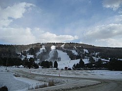    From top left: Naugatuck River in Torrington, Mohawk Mountain Ski Area, Kent Falls State Park, Main Street in North Canaan, West Street in Litchfield | |
Logo | |
 Location within the U.S. state of Connecticut | |
 Connecticut's location within the U.S. | |
| Coordinates: 41°50′N73°13′W / 41.83°N 73.22°W | |
| Country | |
| State | |
| Founded | 2013 |
| Largest city | Torrington |
| Other cities | Winsted |
| Government | |
| • Executive Director | Robert A. Phillips |
| Area | |
• Total | 786.6 sq mi (2,037 km2) |
| Population (2020) | |
• Total | 112,503 |
• Estimate (2024) | 114,101 |
| Time zone | UTC−5 (Eastern) |
| • Summer (DST) | UTC−4 (EDT) |
| Congressional districts | 1st, 5th |
| Website | northwesthillscog |

Interactive map of the Northwest Hills Planning Region
The Northwest Hills Planning Region is a planning region and county-equivalent in the U.S. state of Connecticut. It is served by the coterminous Northwest Hills Council of Governments (NHCOG). In 2022, planning regions were approved to replace Connecticut's counties as county-equivalents for statistical purposes, with full implementation occurring by 2024. [1] [2]
