Marlborough, Connecticut

Last updated
Marlborough, Connecticut
Town of Marlborough
Town Hall, Marlborough CT.jpg
Town Hall
MarlboroughCTseal.PNG
Marlborough CT lg.PNG
Capitol Region incorporated and unincorporated areas Marlborough highlighted.svg
Marlborough, Connecticut
Coordinates: 41°38′07″N72°29′14″W / 41.63528°N 72.48722°W / 41.63528; -72.48722
CountryFlag of the United States.svg  United States
U.S. state Flag of Connecticut.svg  Connecticut
County Hartford
Region Capitol Region
Incorporated1803
Government
  Type Selectman-town meeting
  SelectmanGreg Lowrey (R)
  SelectmanJoseph J. Asklar (R)
  SelectmanBetty O'Brien (D)
  SelectmanDebbie Bourbeau (U)
  Interim Town ManagerAmy Traversa (D)
Area
  Total23.5 sq mi (61 km2)
  Land23.4 sq mi (60.5 km2)
  Water0.2 sq mi (0.4 km2)
Elevation
538 ft (164 m)
Population
 (2020)
  Total6,133
  Density260/sq mi (100/km2)
Time zone UTC-5 (Eastern)
  Summer (DST) UTC-4 (Eastern)
ZIP Code
06447
Area code(s) 860/959
FIPS code 09-45820
GNIS feature ID0213457
Website marlboroughct.net

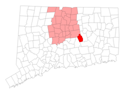
Marlborough is a town in Hartford County, Connecticut, United States. It contains the census-designated place (CDP) of Terramuggus. The town is part of the Capitol Planning Region. The town's population was 6,133 at the 2020 census. [1] Marlborough is a suburban and rural community. The local high school is RHAM High School. In 2013, Marlborough ranked third (of 24) in Connecticut Magazine's biannual ranking of Connecticut small towns. [2] Educationally, RHAM High School, which serves Marlborough, Hebron, and Andover students, is one of the top-ranked regional high schools in the state on the SAT in 2017, and 11th highest-performing school in the state on the test. [3] The town is home to Elmer Theines-Mary Hall elementary school which serves Pre-K through 6th grade. The school scores above state average on standardized testing and student progress. [4]

Contents

History

The earliest inhabitants of present-day Marlborough, prior to the arrival of the English settlers, were the Podunk people, an indigenous people who spoke an Algonquian language. The town's origins can be traced back to 1648, when (John) Sadler's Ordinary, a rest stop from the colonical era, was established. This establishment, the second of its kind in Connecticut Colony after Hartford, served as a crossroads during colonial times. Travelers would stop to rest at the Buell House (now the Marlborough Tavern) located at the heart of what is now Marlborough center. Although the original Sadler's Ordinary (Inn) eventually went out of business, a new Sadler's Ordinary was built in a new location in 1970 and continues to operate today. [5]

In 1747, William Buell and Joel Foote petitioned the colonial General Court for permission to form an Ecclesiastical Society and establish the town of Marlborough. In 1749, they began constructing the First Congregational Church which was not completed until 1803. [6] On October 13, 1803, Marlborough was officially incorporated, encompassing land from portions of three neighboring towns: Glastonbury, Colchester (New London County) and Hebron (Tolland County). [7] [8] The town took its name from Marlborough, Massachusetts, [9] which was named after Marlborough, Wiltshire in England.

By 1907 the town had a population of fewer than 305 residents. It wasn’t until the 1960s that Marlborough was rediscovered as a bedroom community for white-collar professionals working in Hartford. [10] A comprehensive history of the town titled Reflections Into Marlborough's History was published in 2007.

Geography

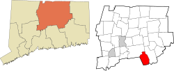
According to the United States Census Bureau, the town has a total area of 23.5 square miles (60.9 km2), of which 23.4 square miles (60.5 km2) is land and 0.15 square miles (0.4 km2), or 0.73%, is water. [11] Marlborough is adjacent to four other Connecticut towns (Glastonbury to the north, East Hampton to the west, Colchester to the south, and Hebron to the east). East Hampton, Colchester and Hebron are each in different counties from each other and from Marlborough.

Route 2, a two-lane highway (sometimes three) in most sections, bisects the town, and there are three Marlborough exits, at South Main Street, Route 66, and West Road, although there are exits westbound only for South Main and eastbound only for West Road. It takes approximately 15– 20 minutes to get to Hartford, 40 minutes to New London, 45 minutes to New Haven, and 40 minutes to Springfield, MA. Marlborough is generally equidistant between Boston and New York. Boston is an hour and 45 minutes away, while New York City is a two-hour car ride, pending traffic conditions. Popular vacation areas are also reasonable drives from Marlborough. The Berkshire Mountains are an hour and 20 minutes away, and popular Rhode Island beaches, depending on which one you go to, are an hour (Misquamicut, Westerly) to an hour and 20 minutes away (Narragansett).

Demographics

Historical population
CensusPop.Note
1820 1,954
1850 832
1860 682−18.0%
1870 476−30.2%
1880 391−17.9%
1890 58248.8%
1900 322−44.7%
1910 302−6.2%
1920 3030.3%
1930 3195.3%
1940 47649.2%
1950 90189.3%
1960 1,961117.6%
1970 2,99152.5%
1980 4,74658.7%
1990 5,53516.6%
2000 5,7093.1%
2010 6,40412.2%
2020 6,133−4.2%
U.S. Decennial Census [12]

As of the census of 2010, [13] there were 6,404 people, 2,292 households, and 1,820 families residing in the town. As of the 2000 census, the population density was 245.2 inhabitants per square mile (94.7/km2). There were 2,057 housing units at an average density of 88.4 per square mile (34.1/km2). The racial makeup of the town was 65.3% White, 1.3% African American, 30.1% Native American, 1.6% Asian, 0.2% from other races, and 1.4% from two or more races. Hispanic or Latino of any race were 2.8% of the population.

There were 2,292 households, out of which 36.9% had children under the age of 18 living with them, 68.9% were married couples living together, 7.5% had a female householder with no husband present, and 20.6% were non-families. 15.8% of all households were made up of individuals, and 5.8% had someone living alone who was 65 years of age or older. The average household size was 2.75 and the average family size was 3.09.

In the town, the population was spread out, with 27.4% under the age of 18, 3.4% from 20 to 24, 22.7% from 25 to 44, 34.1% from 45 to 64, and 12.5% who were 65 years of age or older. The median age was 43 years.

The median income for a household in the town was $139,255 and the median income for a family was $159,376. Males had a median income of $98,789 versus $64,959 for females. The per capita income for the town was $58,805. About 0.3% of families and 1.0% of the population were below the poverty line, including none of those under age 18 and 0.5% of those age 65 or over.

Government and politics

Voter Registration and Party Enrollment as of October 27, 2020 [14]
PartyActive VotersInactive VotersTotal VotersPercentage
Democratic 1,4101061,51630.64%
Republican 1,248831,33126.91%
Unaffiliated 1,8741141,98840.19%
Minor Parties10661122.26%
Total4,6383094,947100%
Marlborough town vote
by party in presidential elections [15]
Year Democratic Republican Third Parties
2020 52.2%2,11945.8% 1,8612.0% 79
2016 46.36% 1,68748.53%1,7665.11% 186
2012 51.04%1,79147.53% 1,6681.43% 50
2008 55.93%2,07143.05% 1,5941.03% 38
2004 50.96%1,85047.11% 1,7101.93% 70
2000 50.99%1,65443.50% 1,4115.52% 179
1996 48.25%1,37935.93% 1,02715.82% 452
1992 37.02%1,18733.00% 1,05829.98% 961
1988 44.61% 1,23054.15%1,4931.23% 34
1984 32.84% 82566.88%1,6800.28% 7
1980 32.66% 77147.18%1,11420.16% 476
1976 43.48% 85056.01%1,0950.51% 10
1972 36.41% 60362.68%1,0380.91% 15
1968 43.27% 46949.45%5367.29% 79
1964 65.35%59434.65% 3150.00% 0
1960 45.29% 40954.71%4940.00% 0
1956 33.15% 24366.85%4900.00% 0

Notable people

Points of interest

Related Research Articles

<span class="mw-page-title-main">Hartford County, Connecticut</span> County in Connecticut, United States

Hartford County is a county located in the north central part of the U.S. state of Connecticut. According to the 2020 census, the population was 899,498, making it the second-most populous county in Connecticut. Hartford County contains the city of Hartford, the state capital of Connecticut and the county's most populous city, with 121,054 residents at the 2020 census. Hartford County is included in the Hartford-East Hartford-Middletown metropolitan statistical area.

<span class="mw-page-title-main">Litchfield County, Connecticut</span> County in Connecticut, United States

Litchfield County is in northwestern Connecticut. As of the 2020 census, the population was 185,186. The county was named after Lichfield, in England. Litchfield County has the lowest population density of any county in Connecticut and is the state's largest county by area.

<span class="mw-page-title-main">Middlesex County, Connecticut</span> County in Connecticut, United States

Middlesex County is a county in the south central part of the U.S. state of Connecticut. As of the 2020 census, the population was 164,245. The county was created in May 1785 from portions of Hartford County and New London County.

<span class="mw-page-title-main">New Haven County, Connecticut</span> County in Connecticut, United States

New Haven County is a county in the south central part of the U.S. state of Connecticut. As of the 2020 census, the population was 864,835, making it the third-most populous county in Connecticut. Two of the state's top 5 largest cities, New Haven (3rd) and Waterbury (5th), are part of New Haven County.

<span class="mw-page-title-main">New London County, Connecticut</span> County in Connecticut, United States

New London County is in the southeastern corner of Connecticut and comprises the Norwich-New London, Connecticut Metropolitan Statistical Area, which is also included in the Hartford-East Hartford, Connecticut Combined Statistical Area. There is no county government and no county seat, as is the case with all eight of Connecticut's counties; towns are responsible for all local government activities, including fire and rescue, snow removal, and schools.

<span class="mw-page-title-main">Tolland County, Connecticut</span> County in Connecticut, United States

Tolland County is a county in the northeastern part of the U.S. state of Connecticut. As of the 2020 census, its population was 149,788. It is incorporated into 13 towns and was originally formed on 13 October 1785 from portions of eastern Hartford County and western Windham County.

<span class="mw-page-title-main">Berlin, Connecticut</span> Town in Connecticut, United States

Berlin is a town in the Capitol Planning Region, Connecticut, United States. The population was 20,175 at the 2020 census. It was incorporated in 1785. The geographic center of Connecticut is located in the town. Berlin is residential and industrial, and is served by the Amtrak station of the same name. Berlin also has two hamlets: Kensington and East Berlin.

<span class="mw-page-title-main">Bloomfield, Connecticut</span> Town in Connecticut, United States

Bloomfield is a suburb of Hartford in the Capitol Planning Region, Connecticut, United States. The town's population was 21,535 at the 2020 census. Bloomfield is best known as the headquarters of healthcare services company Cigna.

<span class="mw-page-title-main">Rocky Hill, Connecticut</span> Town in Connecticut, United States

Rocky Hill is a town in Hartford County, Connecticut, United States. The town is part of the Capitol Planning Region. The population was 20,845 at the 2020 census. It was originally land of the Wangunks. Europeans began to settle the area of Rocky Hill in 1650, as part of Wethersfield, the neighboring town to the north. In 1722, the area became known as Stepney Parish, until it was independently incorporated in 1843. Rocky Hill’s location on the Connecticut River made it a natural port for Wethersfield and an early center for shipbuilding, agriculture, and trade.

<span class="mw-page-title-main">Barkhamsted, Connecticut</span> Town in Connecticut, United States

Barkhamsted is a town in Litchfield County, Connecticut, United States. It contains seven villages: West Hill, Mallory, Barkhamsted Center, Center Hill, Washington Hill, Pleasant Valley, and Riverton. The population was 3,647 at the 2020 census, down from 3,799 at the 2010 census. The town is part of the Northwest Hills Planning Region. Barkhamsted was first incorporated in 1779, and named after Berkhamsted, Hertfordshire, England.

<span class="mw-page-title-main">Colebrook, Connecticut</span> Town in Connecticut, United States

Colebrook is a town in Litchfield County, Connecticut, United States. The population was 1,361 at the 2020 census. The town is part of the Northwest Hills Planning Region. Colebrook was named after Colebrooke in the English county of Devon; the reason is now unknown.

<span class="mw-page-title-main">Harwinton, Connecticut</span> Town in Connecticut, United States

Harwinton is a town in Litchfield County, Connecticut, United States. The population was 5,484 at the 2020 census. The town is part of the Northwest Hills Planning Region. The high school is Lewis S. Mills.

<span class="mw-page-title-main">Winchester, Connecticut</span> Town in Connecticut, United States

Winchester is a town in Litchfield County, Connecticut, United States. The population was 10,224 at the 2020 census. The city of Winsted is located in Winchester. The town is part of the Northwest Hills Planning Region.

<span class="mw-page-title-main">Bozrah, Connecticut</span> Town in Connecticut, United States

Bozrah is a town in New London County, Connecticut, United States. The town is part of the Southeastern Connecticut Planning Region. The population was 2,429 at the 2020 census. Bozrah contains three villages: Fitchville, the town center; Leffingwell, a crossroads on Route 82; and Gilman, a mill village along Fitchville Road.

<span class="mw-page-title-main">Colchester, Connecticut</span> Town in Connecticut, United States

Colchester is a town in New London County, Connecticut, United States. The town is part of the Southeastern Connecticut Planning Region. The population was 15,555 at the 2020 census. In 2010 Colchester became the first town in Connecticut, and the 36th in the country, to be certified with the National Wildlife Federation as a Community Wildlife Habitat.

<span class="mw-page-title-main">Hebron, Connecticut</span> Town in Connecticut, United States

Hebron is a town in Tolland County, Connecticut, United States. The town is part of the Capitol Planning Region. The population was 9,098 at the 2020 census. Hebron was incorporated May 26, 1708. In 2010, Hebron was rated #6 in Top Towns in Connecticut with population between 6,500 and 10,000, according to Connecticut Magazine.

<span class="mw-page-title-main">Willington, Connecticut</span> Town in Connecticut, United States

Willington is a town in Tolland County, Connecticut, United States. The town is part of the Capitol Planning Region. The population was 5,566 at the 2020 census.

<span class="mw-page-title-main">Hebron, Indiana</span> Town in Indiana, United States

Hebron is a town in Boone Township, Porter County, Indiana, United States. The population was 3,724 at the 2010 census.

<span class="mw-page-title-main">New Marlborough, Massachusetts</span> Town in Massachusetts, United States

New Marlborough is a town in Berkshire County, Massachusetts, United States. It is part of the Pittsfield, Massachusetts Metropolitan Statistical Area. The population was 1,528 at the 2020 census. New Marlborough consists of five villages: Clayton, Hartsville, Mill River, New Marlborough Village and Southfield.

Colchester is a town in Delaware County, New York, United States. The population was 2,077 at the 2010 census. The town is in the southwestern part of the county.

References

  1. "Census - Geography Profile: Marlborough town, Hartford County, Connecticut". United States Census Bureau . Retrieved December 17, 2021.
  2. "Rating the Towns 2013: Median Home Sale price $175,000-$224,999". Connecticut Magazine . Archived from the original on June 21, 2016.
  3. de la Torre, Vanessa (August 1, 2017). "SAT Scores Improve Among Connecticut 11th-Graders, But Achievement Gap Remains". courant.com. Retrieved 2020-12-05.
  4. , additional text.
  5. Rhinelander, David (31 July 1998). "Just an Ordinary Tale of an Early Colonial Tavern". Hartford Courant. Retrieved 15 September 2019.
  6. "Town of Marlborough." Archived 2008-07-24 at the Wayback Machine Retrieved 2009-10-23.
  7. Conn. Spec. Acts 1803, 2:1157-1158.
  8. "Hartford County". Archived from the original on November 10, 2013. Retrieved January 7, 2013.
  9. The Connecticut Magazine: An Illustrated Monthly. Connecticut Magazine Company. 1903. p. 333.
  10. "Marlborough". CThistory.org. 28 October 2011. Retrieved 15 September 2019.
  11. "Geographic Identifiers: 2010 Demographic Profile Data (G001): Marlborough town, Hartford County, Connecticut". U.S. Census Bureau, American Factfinder. Archived from the original on February 12, 2020. Retrieved November 28, 2012.
  12. "Census of Population and Housing". Census.gov. Retrieved June 4, 2015.
  13. Bureau, U.S. Census. "U.S. Census website". United States Census Bureau . Retrieved 2016-11-15.
  14. "Connecticut Voter Registration" (PDF).
  15. "General Elections Statement of Vote 1922". CT.gov - Connecticut's Official State Website. Retrieved 2020-12-05.
  16. "William Henry Richmond," National Cyclopaedia of American Biography: Volume 9. New York: James T. White and Company, 1899; pp. 103-104.
  17. "MARLBOROUGH ARTS CENTER – A Non-Profit Regional Center for Fine Arts, Performing Arts and Fine Crafts". marlborougharts.org.

Further reading