
Moodus is a village in the town of East Haddam, Connecticut, United States. The village is the basis of a census-designated place (CDP) of the same name. The population of the CDP was 1,982 as of the census of 2020.

The Connecticut Lakes are a group of lakes in Coos County, northern New Hampshire, United States, situated along the headwaters of the Connecticut River. They are accessed via the northernmost segment of U.S. Route 3, between the village of Pittsburg and the Canada port of entry south of Chartierville, Quebec. The lakes are located within the boundaries of Pittsburg, but are far from the town center. Connecticut Lakes State Forest adjoins them.
Lake Attitash is a lake located on the border of Merrimac, Massachusetts and Amesbury, Massachusetts, and constitutes at least a portion of Amesbury's water supply.

Indian Lake is a reservoir and unincorporated community situated 505 feet (154 m) above sea level in Denville Township, New Jersey. Snake Hill rises 780 feet (238 m) to its west and Chestnut Hill rises 640 feet (195 m) to its east.

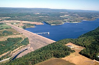
Raystown Lake is a reservoir in Huntingdon County, Pennsylvania. It is the largest lake that is entirely within Pennsylvania. The original lake was built by the Simpson family of Huntingdon as a hydroelectric project. The current 8,300-acre (34 km2) Raystown Lake was completed in 1973 by the Army Corps of Engineers. Raystown is around 200 feet (61 m) deep in the deepest area near the dam. The lake was created primarily to control floods, provide electricity, and support recreational activities. Allegheny Electric Cooperative operates the Raystown Hydroelectric Project and William F. Matson Generating Station at the Raystown Dam,a 21 MW, two-unit hydroelectric project.

New Bullards Bar Reservoir is a large reservoir in northeastern Yuba County, California, United States, at an elevation of 2,000 feet (610 m) in the Tahoe National Forest and about 30 miles (50 km) northeast of Yuba City. The 969,600 acre-foot (1.1960×10⁹ m3) reservoir is formed by New Bullards Bar Dam on the North Yuba River, a tributary of the Yuba River. It also receives a portion of the Middle Fork's flow that is diverted to the reservoir via tunnels.
The Manasquan Reservoir is a source of water for municipalities and utilities, as well as a 1,204-acre (4.87 km2) park, located in Howell Township, in Monmouth County, New Jersey, United States. The reservoir doubles as a park that is part of the Monmouth County Park System. The park has trails, a visitor center, a nature/environmental center, a boat launching area and several dikes for fishing, among its facilities. The reservoir itself, which is dammed from the Manasquan River, is operated by the New Jersey Water Supply Authority, which is a part of the much larger Raritan Basin Watershed. The nature trails circling around the reservoir are what makes this county park as one of the most popular hiking destinations in Central New Jersey, as the park receives over one million visitors a year. It is reachable by car and there are five parking lots, including one for vehicles hauling trailers. The park's trails are open to walkers, runners, hikers, bicyclists and equestrians.

Otis Reservoir is a 1,085-acre (4 km2) reservoir located primarily in Otis, Massachusetts, United States. Small portions are also in Tolland, MA, and Blandford, MA. The lake is popular for boating, swimming, fishing, water skiing, snowmobiling, camping, and water-related recreation. Fish include bass, white perch, yellow perch, tiger muskies, catfish, and bluegills. The reservoir is stocked with trout by the Massachusetts Division of Fisheries & Wildlife.
Beltzville State Park is a 2,972.39-acre (1,202.88 ha) Pennsylvania state park in Franklin and Towamensing townships, Carbon County, Pennsylvania in the United States. The park opened in 1972, and was developed around the U.S. Army Corps of Engineers flood control project Beltzville Dam on Pohopoco Creek. The village of Big Creek Valley was vacated in 1966 to make way for Beltzville Lake.

Lake Wawasee is a large, natural, freshwater lake southeast of Syracuse in Kosciusko County, Indiana. It is the largest natural lake within Indiana's borders.
Grapevine Lake is a reservoir in North Texas about 20 mi (32 km) northwest of Dallas and northeast of Fort Worth. It was impounded in 1952 by the U.S. Army Corps of Engineers when they dammed Denton Creek, a tributary of Trinity River.

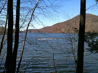
The Salmon River is formed at the confluence of the Blackledge and Jeremy rivers about one mile west of North Westchester, Connecticut. It drains 96,000 acres and courses for 10.4 miles (16.7 km) to Salmon Cove near Moodus where it flows into the Connecticut River. The Salmon River is probably the largest stream and watershed whose sources and mouth are entirely within the limits of Connecticut.

Lake Waramaug is a 656-acre (265 ha) lake occupying parts of the towns of Kent, Warren and Washington in Litchfield County, Connecticut, United States, approximately 24 miles (39 km) north of Danbury. The lake is named after Chief Waramaug, who wintered in the area surrounding Lake Waramaug.

Lake Holiday is an unincorporated community and census-designated place (CDP) in Union Township, Montgomery County, in the U.S. state of Indiana. It is a private community on the banks of its eponymous body of water. As of the 2020 census, the community had a population of 921 residents.
The Lillinonah Trail is a 5.9-mile (9.5 km) Blue-Blazed hiking trail "system" in the lower Housatonic River valley in Fairfield County and, today, is entirely in Newtown. Most of the trail is in the upper block of Paugussett State Forest.

Lake Zoar is a reservoir on the Housatonic River in the U.S. state of Connecticut. It was formed by the completion of the Stevenson Dam, which flooded an area of Oxford and Stevenson named "Pleasantvale" or "Pleasant Vale". "Connecticut's Lakes Reflect Our History, Present". Retrieved 2018-04-02. The towns of Monroe, Newtown, Oxford, and Southbury border Lake Zoar. The name Zoar originates from corner of Newtown and Monroe that once called itself Zoar after the Biblical city Zoara near the Dead Sea.

Lake Chaffee is a small, shallow, man-made lake located approximately 2 miles (3.2 km) northwest of the hamlet of Westford in the town of Ashford in Windham County, northeastern Connecticut. The lake has an area of 54 acres (22 ha) and a maximum depth of 11 feet (3.4 m). Its average surface elevation is 856 feet (261 m) above sea level.
Crooked Lake is a recreational lake located in the south-eastern region of the Canadian province of Saskatchewan. It is part of a chain of lakes in the Qu'Appelle Valley and, like many of the other lakes in the valley, there's a dam at the eastern end that controls water levels.

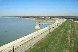
Council Grove Lake is a reservoir on the Neosho River in east-central Kansas. Built and managed by the U.S. Army Corps of Engineers, it is used for flood control, recreation, and water supply.

Johnsonville Village, once a thriving mill community, then a Victorian Era tourist attraction, was an abandoned ghost town in East Haddam, Connecticut, United States. On July 7, 2017, the property was acquired by the Iglesia ni Cristo, an independent, nontrinitarian Christian denomination based in the Philippines.

