
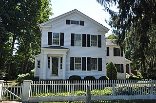
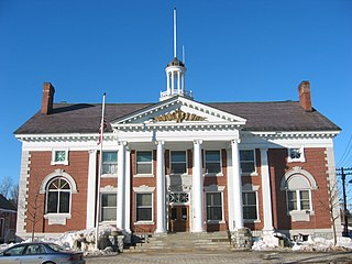
The Worthington Ridge Historic District encompasses the historic town center of Berlin, Connecticut. It runs mostly along Worthington Ridge Road from the intersection of Mill Street to Sunset Lane. This section of road was historically part of the Boston Post Road laid out in 1673, and is now lined by a diversity of residential architecture and several of the town's civic buildings. In 1974, the Berlin Historic District was formed in order to preserve the integrity of the architecture of the village. The district was listed on the National Register of Historic Places in 1989.

Plainfield Street Historic District is a historic district in Plainfield, Connecticut that encompasses the historic area of Plainfield Village, the town center of Plainfield. The district is linear, being located along Route 12 between Railroad Avenue and Route 14A. It has been the center of the town's civic life since its settlement in the early 18th century, and includes two centuries of architectural styles. The district was listed on the National Register of Historic Places in 1991.

The Bradstreet Historic District encompasses the rural 19th-century village of Bradstreet in Hatfield, Massachusetts. It is centered at the junction of Depot Road and Main Street, and includes properties lining those two streets and Old Farm Road. Most of the buildings in the area date to the second half of the 19th century, featuring architectural styles typical of the period, including Queen Anne, Second Empire, Italianate, and Colonial Revival. The village grew on land that was originally granted to colonial governor Simon Bradstreet and divided in 1682, and has remained largely agricultural since then. The district was listed on the National Register of Historic Places in 1997.

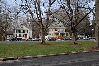
The Agawam Center Historic District is a historic district that encompasses part of the historic center of Agawam, Massachusetts. The district covers most of the buildings along Elm Street and Main Street radiating out from their intersection in both directions. The district is predominantly residential, although it does contain many commercial, industrial, and civic buildings. Many of the buildings in the district stand at a uniform setback from the street, giving the district a coherent feel.
Hattertown is a village in the town of Newtown, Connecticut, United States that is listed on the National Register of Historic Places as the Hattertown Historic District and includes a smaller local historic district.

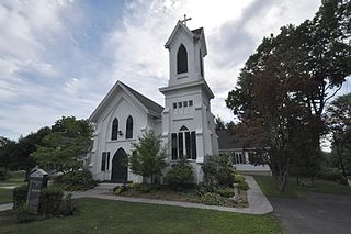
The East Plymouth Historic District is a historic district in the town of Plymouth, Connecticut, United States. It encompasses a small rural village in the northeastern part of the town, whose main focus is the 1792 St. Matthew's Church, one of the oldest surviving Episcopal church buildings in the state. The district runs along East Plymouth Road on either side of its junction with Marsh Road, and includes predominantly Greek Revival residential buildings erected in the early to mid-19th century. The district was listed on the National Register of Historic Places in 1985.

The Main Street Historic District encompasses the historic civic, commercial, and residential center of Durham, Connecticut. The district is primarily linear and runs along Main Street from between Higganum Road and Town House Road in the south to Talcott Lane in the north, and along Maple Avenue, which parallels Main Street. The district includes most of its colonial architecture, as well as many of its civic buildings. It was listed on the National Register of Historic Places in 1986.

The Graniteville Historic District is a mainly residential historic district in Waterford, Connecticut, United States. It is ranged along Rope Ferry Road, near granite quarries that were once a major industry in the town. Most of the 31 historical buildings in the district are plain residences occupied by quarry workers; also included are the c. 1878 Graniteville School at 239 Rope Ferry Road, and the house of John Palmer, one of the proprietors of the quarries, at 218 Rope Ferry Road. His house, a c. 1860 Italianate updating of an older house, is the most elaborate house in the district. The district was listed on the National Register of Historic Places in 2003.

The Clinton Downtown Historic District is a historic district located in the village of Clinton in Clinton Township in the northernmost portion of Lenawee County, Michigan. It consists of most of the 100 block of U.S. Route 12, known locally as West Michigan Avenue, plus Memorial Park at 200 West Michigan. The district was added to the National Register of Historic Places on April 27, 2010.

The Granby Center Historic District is a predominantly residential historic district encompassing a portion of the village of Granby Center in Granby, Connecticut. The village developed in the 18th century as a farming center, and a now includes a variety of architectural styles from the late 18th to early 20th centuries. The district was listed on the National Register of Historic Places (NRHP) in 1985.
The Washington Street Historic District encompasses a residential area of Middletown, Connecticut that has a long history as a fashionable and desirable neighborhood. Extending along Washington Street and Washington Terrace between Main and Jackson Streets, the area has a broad diversity of residential architecture dating from 1752 to 1931, reflecting the city's patterns of growth. The district was listed on the National Register of Historic Places in 1985.
Bridgewater Center Historic District encompasses the traditional town center of Bridgewater, Connecticut. Centered at the junction of Main Street with Clapboard and Hat Shop Hill Roads, it developed in the early 19th century as a civic center, even before the town's 1856 incorporation from New Milford. The architecture of the center is largely reflective of the first half of the 19th century, including Greek Revival and Federal style buildings. It was listed on the National Register of Historic Places in 2000.

The Grafton Village Historic District encompasses the historic village center of the town of Grafton, Vermont. The village was developed in the early-to-mid 19th century, and has retained the character of that period better than many small communities in the state. The district was listed on the National Register of Historic Places in 2010.

The Danby Village Historic District encompasses much of the town center of Danby, Vermont. It is centered on a stretch of Main Street, roughly between Depot Street and Brook Road. The village has a cohesive collection of mid-19th century architecture, mostly residential, with a modest number of later additions. The district was listed on the National Register of Historic Places in 1983.
The East Poultney Historic District encompasses the historic center of the rural village of East Poultney, Vermont. The district is centered on the triangular green at the center of the village, and was developed mainly from the late 18th through mid-19th centuries, producing a village with strong Federal and Greek Revival architecture. It was listed on the National Register of Historic Places in 1978.

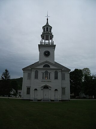
The Depot Square Historic District encompasses the historic commercial business district of Randolph, Vermont. Developed in the mid-19th century around the facilities of the Central Vermont Railway, the area features a high concentration of well-preserved Second Empire and late Victorian commercial architecture. It was listed on the National Register of Historic Places in 1975.
The Stowe Village Historic District encompasses most of the village center of Stowe, Vermont. Since the 19th century, the village has been one of Vermont's major resort centers, and its center is architecturally reflective of this history. It was listed on the National Register of Historic Places in 1978.

The Burlington–Harmony Hill Roads Historic District encompasses a historic rural agricultural crossroads village in eastern Harwinton, Connecticut. Stretching mainly along Harmony Hill Road north of its junction with Burlington Road, it includes residential buildings dating from the mid-18th to late 19th centuries. The district was listed on the National Register of Historic Places in 1996.

The Broad Street Green Historic District encompasses the historic late-19th century town center of Windsor, Connecticut. It is centered around the Broad Street Green, a public park extending on the east side of Broad Street between Union and Batchelder Streets, and includes a diversity of architecture spanning much of the town's long history. It was listed on the National Register of Historic Places in 1999.
The Old Lyme Historic District encompasses the historic village center of Old Lyme, Connecticut. Located mainly on Lyme Street south of Interstate 95, the village, settled in the mid-17th century, has an architectural history dating to the early 18th century, flourishing as a shipbuilding center and home to many ship captains. It was listed on the National Register of Historic Places in 1971.


