South Woodstock, Connecticut

Last updated
South Woodstock, Connecticut
General Samuel McClellan House, South Woodstock CT.jpg
General Samuel McClellan House
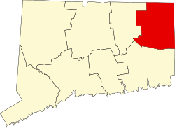
Windham County Connecticut incorporated and unincorporated areas South Woodstock highlighted.svg
Location in Windham County and the state of Connecticut.
Coordinates: 41°56′20″N71°57′34″W / 41.93889°N 71.95944°W / 41.93889; -71.95944 Coordinates: 41°56′20″N71°57′34″W / 41.93889°N 71.95944°W / 41.93889; -71.95944
Country United States
State Connecticut
County Windham
Town Woodstock
Area
  Total5.4 sq mi (14 km2)
  Land5.3 sq mi (14 km2)
  Water0.2 sq mi (0.52 km2)
Elevation
436 ft (133 m)
Population
 (2010)
  Total1,291
  Density240/sq mi (92/km2)
Time zone UTC-5 (Eastern (EST))
  Summer (DST) UTC-4 (EDT)
ZIP code
06281
Area code 860
FIPS code 09-71530
GNIS feature ID2377865 [1]

South Woodstock is a village [2] and census-designated place (CDP) in Woodstock, Windham County, Connecticut, United States. The population was 1,291 at the 2010 census. [3]

Contents

It is notable as the former home of the now-defunct Annhurst College.

Geography

According to the United States Census Bureau, the CDP has a total area of 5.4 square miles (14 km2), of which, 5.3 square miles (14 km2) of it is land and 0.2 square miles (0.52 km2) of it (2.96%) is water.

Demographics

As of the census [4] of 2000, there were 1,211 people, 499 households, and 333 families residing in the CDP. The population density was 230.3 inhabitants per square mile (88.9/km2). There were 565 housing units at an average density of 107.5 per square mile (41.5/km2). The racial makeup of the CDP was 97.19% White, 0.08% African American, 0.08% Native American, 0.58% Asian, 0.17% from other races, and 1.90% from two or more races. Hispanic or Latino of any race were 0.91% of the population.

There were 499 households, out of which 30.7% had children under the age of 18 living with them, 54.7% were married couples living together, 8.2% had a female householder with no husband present, and 33.1% were non-families. 26.3% of all households were made up of individuals, and 10.2% had someone living alone who was 65 years of age or older. The average household size was 2.43 and the average family size was 2.95.

In the CDP the population was spread out, with 25.0% under the age of 18, 7.8% from 18 to 24, 31.4% from 25 to 44, 22.8% from 45 to 64, and 13.0% who were 65 years of age or older. The median age was 38 years. For every 100 females, there were 101.5 males. For every 100 females age 18 and over, there were 93.2 males.

The median income for a household in the CDP was $37,458, and the median income for a family was $44,821. Males had a median income of $38,083 versus $26,140 for females. The per capita income for the CDP was $21,239. None of the families and 3.5% of the population were living below the poverty line, including no under eighteens and 9.9% of those over 64.

Related Research Articles

<span class="mw-page-title-main">Tranquillity, California</span> Census-designated place in California, United States

Tranquillity is a census-designated place (CDP) in Fresno County, California, United States. It is located 10 miles (16 km) southeast of Mendota, at an elevation of 164 feet (50 m). The population was 799 at the 2010 census, down from 813 at the 2000 census. Tranquillity High School is the only high school in Tranquillity.

<span class="mw-page-title-main">Broad Brook, Connecticut</span> Census-designated place in Connecticut, United States

Broad Brook is a neighborhood and census-designated place (CDP) in the town of East Windsor, Hartford County, Connecticut, United States. As of the 2010 census, the CDP population was 4,069.

<span class="mw-page-title-main">Kensington, Connecticut</span> Census-designated place in Connecticut, United States

Kensington is a census-designated place (CDP) and section of the town of Berlin in Hartford County, Connecticut, United States. The Berlin town offices are located in Kensington. The population was 8,459 at the 2010 census.

<span class="mw-page-title-main">North Granby, Connecticut</span> Census-designated place in Connecticut, United States

North Granby is a village and census-designated place (CDP) in Hartford County, Connecticut, United States. It is part of the town of Granby. The population was 1,944 at the 2010 census.

Sherwood Manor is a census-designated place (CDP) within the town of Enfield in Hartford County, Connecticut, United States. The population was 5,410 at the 2010 census.

<span class="mw-page-title-main">Terramuggus, Connecticut</span> Census-designated place in Connecticut, United States

Terramuggus is a census-designated place (CDP) in the town of Marlborough, Hartford County, Connecticut, United States. It contains the town center village and surrounding areas. The population was 1,025 at the 2010 census.

<span class="mw-page-title-main">Thompsonville, Connecticut</span> Census-designated place in Connecticut, United States

Thompsonville is a census-designated place (CDP) in the town of Enfield in Hartford County, Connecticut, United States. The population of the CDP was 8,577 at the 2010 census.

<span class="mw-page-title-main">Essex Village, Connecticut</span>

Essex Village is a village and census-designated place (CDP) in the town of Essex, Connecticut in the United States. The population was 2,573 at the 2000 census. The government offices of the town are located within the village.

Old Saybrook Center is a community and census-designated place (CDP) in Old Saybrook, a town in Middlesex County, Connecticut, United States. The population was 1,962 at the 2000 census. The CDP includes the traditional town center and the peninsula known as Saybrook Point.

Saybrook Manor is a community and census-designated place (CDP) in Old Saybrook, a town in Middlesex County, Connecticut, United States. The population was 1,133 at the 2000 census. The Saybrook Manor section is generally the area south of U.S. Route 1 between the Westbrook town line and the Oyster River.

<span class="mw-page-title-main">Long Hill, Groton, Connecticut</span> Census-designated place in Connecticut, United States

Long Hill is a census-designated place (CDP) in the town of Groton in New London County, Connecticut, United States. The population was 4,205 at the 2010 census.

<span class="mw-page-title-main">Old Mystic, Connecticut</span> Census-designated place in Connecticut, United States

Old Mystic is a village and census-designated place (CDP) located in the town of Stonington in New London County, Connecticut, United States. The population was 3,554 at the 2010 census.

<span class="mw-page-title-main">Poquonock Bridge, Connecticut</span> Census-designated place in Connecticut, United States

Poquonnock Bridge is a village and census-designated place (CDP) in the town of Groton in New London County, Connecticut, United States. The population was 1,727 at the 2010 census.

<span class="mw-page-title-main">Plainfield Village, Connecticut</span> Village in Connecticut, United States

Plainfield Village is a village and census-designated place (CDP) in the town of Plainfield, Connecticut in the United States. The population was 2,557 at the 2010 census. It is located in the southwest part of town, in the area west of I-395 and south of Route 14. The village is also the core of the Plainfield, CT urban cluster.

<span class="mw-page-title-main">Woodstock Township, Michigan</span> Civil township in Michigan, United States

Woodstock Township is a civil township of Lenawee County, Michigan, United States. As of the 2000 census, the township population was 3,468.

<span class="mw-page-title-main">Leisure Knoll, New Jersey</span> Census-designated place in New Jersey, United States

Leisure Knoll is an unincorporated community and census-designated place (CDP) located within Manchester Township, in Ocean County, New Jersey, United States. As of the 2010 United States Census, the CDP's population was 2,490.

<span class="mw-page-title-main">Suffield Depot, Connecticut</span> Census-designated place in Connecticut, United States

Suffield Depot is the name of a census-designated place (CDP) corresponding to the village of Suffield, the primary settlement of the town of Suffield, Connecticut, in Hartford County. The population of the CDP was 1,325 as of the 2010 census.

<span class="mw-page-title-main">Glastonbury Center, Connecticut</span> Census-designated place in Connecticut, United States

Glastonbury Center is a census-designated place (CDP) that constitutes the densely populated center of the town of Glastonbury in Hartford County, Connecticut, United States. The population was 7,387 at the 2010 census, out of a total town population of 34,427.

Salmon Brook is the name of a census-designated place (CDP) corresponding to the village of Granby, the primary settlement of the town of Granby, Connecticut, in Hartford County. The population of the CDP was 2,324 as of the 2010 census.

<span class="mw-page-title-main">Woodstock (CDP), New York</span> CDP in New York, United States

Woodstock is a hamlet in Ulster County, New York, United States. The population was 2,088 at the 2010 census. The community of Woodstock is in eastern part of the Town of Woodstock and is northwest of Kingston. It is located along NY 212 near its junction with NY 375. Although the name of the community and the town lent its name to the Woodstock Festival, that event did not take place in Woodstock.

References

  1. U.S. Geological Survey Geographic Names Information System: South Woodstock
  2. Principal Communities in Connecticut, Dept. of Economic and Community Development
  3. "Census of Population and Housing". Census.gov. Retrieved November 7, 2020.
  4. "U.S. Census website". United States Census Bureau . Retrieved 2008-01-31.