
Mendon is a town in Worcester County, Massachusetts, United States. The population was 6,228 at the 2020 census. Mendon is part of the Blackstone River Valley National Heritage Corridor, an early center of the industrial revolution in the United States. Mendon celebrated its 350th anniversary on May 15, 2017.

Oxford is a town in Worcester County, Massachusetts, United States. The population was 13,347 as of the 2020 United States Census.

King Philip's War was an armed conflict in 1675–1676 between a group of indigenous peoples of the Northeastern Woodlands against the English New England Colonies and their indigenous allies. The war is named for Metacom, the Pokanoket chief and sachem of the Wampanoag who adopted the English name Philip because of the friendly relations between his father Massasoit and the Plymouth Colony. The war continued in the most northern reaches of New England until the signing of the Treaty of Casco Bay on April 12, 1678.
The Massachusett are a Native American tribe from the region in and around present-day Greater Boston in the Commonwealth of Massachusetts. The name comes from the Massachusett language term for "At the Great Hill," referring to the Blue Hills overlooking Boston Harbor from the south.
Praying Indian is a 17th-century term referring to Native Americans of New England, New York, Ontario, and Quebec who converted to Christianity either voluntarily or involuntarily. Many groups are referred to by the term, but it is more commonly used for tribes that were organized into villages. The villages were known as praying towns and were established by missionaries such as the Puritan leader John Eliot and Jesuit missionaries who established the St. Regis and Kahnawake and the missions among the Huron in western Ontario.
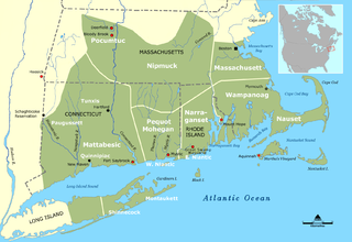
The Nipmuc or Nipmuck people are an Indigenous people of the Northeastern Woodlands, who historically spoke an Eastern Algonquian language, probably the Loup language. Their historic territory Nippenet, meaning 'the freshwater pond place', is in central Massachusetts and nearby parts of Connecticut and Rhode Island.

Praying towns were settlements established by English colonial governments in New England from 1646 to 1675 in an effort to convert local Native Americans to Christianity.

The Hassanamisco Nipmuc Band is the sole state-recognized tribe in the Commonwealth of Massachusetts. They were recognized in 1976 by Governor Michael Dukakis via Executive Order 126. They were briefly known as the Nipmuc Nation, a union of the Hassanamisco Nipmuc and the Chaubunagungamaug Nipmuck bands, during their attempt to receive federal acknowledgment as a Nation. The Hassanamisco Nipmuc Band owns three and a half acres of reservation land in what is present day Grafton, Massachusetts. The Nipmuc are native to Central Massachusetts, Northeastern Connecticut, and parts of Rhode Island.
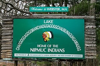
The Webster/Dudley Band of Chaubunagungamaug Nipmuck Indians, also known as the Chaubunagungamaug, Chaubunagungamaug Nipmuck, Pegan or Dudley/Webster Indians, is a cultural heritage group that claims descent from the Nipmuc people. They are a state acknowledged tribe.
The Chaubunagungamaug Reservation refers to the small parcel of land located in the town of Thompson, Connecticut, close to the border with the town of Webster, Massachusetts, and within the bounds of Lake Chaubunagungamaug to the east and the French River to the west. The reservation is used by the descendants of the Nipmuck Indians of the previous reservation, c. 1682–1869, that existed in the same area, who now identify as the Webster/Dudley Band of the Chaubunagungamaug Nipmuck.

The Old Connecticut Path was the Native American trail that led westward from the area of Massachusetts Bay to the Connecticut River Valley, the first of the North American trails that led west from the settlements close to the Atlantic seacoast, towards the interior. The earliest colonists of Massachusetts Bay Colony used it, and rendered it wider by driving cattle along it. The old route is still followed, for part of its length, by Massachusetts Route 9 and Massachusetts Route 126.
Gleasondale is a village straddling the border between the towns of Hudson and Stow in Middlesex County, Massachusetts, United States. It is located along the Assabet River. For many decades it was home to various mills, though it is now primarily residential. According to the Geographic Names Information System (GNIS), Gleasondale is a "populated place" named after Benjamin W. Gleason and Samuel J. Dale.

The Five Mile River is a 23.5-mile-long (37.8 km) river located in Connecticut's northeast corner which flows through the towns of Thompson, Putnam, and Killingly. The original Nipmuc name was Assawaga, meaning "place between" or "halfway place". The Assawaga received its English name from the fact that the first land laid out upon it was "supposed to be about five miles from" Woodstock, Connecticut. The Five Mile is a tributary of the Quinebaug River and is part of the Thames River watershed. Its source is Little Pond, close to the Massachusetts border. It empties into the Quinebaug River at Danielson, near the intersection of Connecticut Route 12 and U.S. Route 6.

The Lancaster Raid was the first in a series of five planned raids on English colonial towns during the winter of 1675-1676 as part of King Philip's War. Metacom, known by English colonists as King Philip, was a Wampanoag sachem who led and organized Wampanoag warriors during the war. Teaming up with Nipmuc and Narragansett warriors, the Wampanoag successfully raided the town of Lancaster, securing provisions and prisoners to help them carry on into their winter offensive.

The Manchaug Village Historic District is a historic district encompassing the 19th century industrial village center of Manchaug in Sutton, Massachusetts. Developed in the 1820s around textile mills on the Mumford River, it was the largest industrial area in Sutton, with at least three mill complexes in operation. The district is centered on the junction of Main Street with Manchaug, Putnam Hill, and Whitins Roads.
The Massachusett dialects, as well as all the Southern New England Algonquian (SNEA) languages, could be dialects of a common SNEA language just as Danish, Swedish and Norwegian are mutually intelligible languages that essentially exist in a dialect continuum and three national standards. With the exception of Massachusett, which was adopted as the lingua franca of Christian Indian proselytes and survives in hundreds of manuscripts written by native speakers as well as several extensive missionary works and translations, most of the other SNEA languages are only known from fragmentary evidence, such as place names. Quinnipiac (Quiripey) is only attested in a rough translation of the Lord's Prayer and a bilingual catechism by the English missionary Abraham Pierson in 1658. Coweset is only attested in a handful of lexical items that bear clear dialectal variation after thorough linguistic review of Roger Williams' A Key into the Language of America and place names, but most of the languages are only known from local place names and passing mention of the Native peoples in local historical documents.
Peter Jethro was an early Native American (Nipmuc) scribe, translator, minister, land proprietor, and Praying Indian affiliated for a period with John Eliot in the praying town of Natick, Massachusetts.

Quinnatisset was a Nipmuc village in Connecticut which became a praying town through the influence of John Eliot and Daniel Gookin. The town was located near what is now Thompson, Connecticut or Pomfret, Connecticut possibly near Thompson Hill Historic District. The name "Quantisset" means "little long river."
Maanexit was a Nipmuc village on the Quinebaug River and Old Connecticut Path in Connecticut. The town was located near what is now Fabyan in Thompson, Connecticut and Woodstock, Connecticut. The name of the town means either "where the road lies" or "where we gather" which may have been "alluding to a settlement of Christian Indians in the immediate vicinity." The village became an Indian praying town through the influence of John Eliot and Daniel Gookin.
The Praying Indians of Natick were a community of Indigenous Christian converts, known as Praying Indians, in the town of Natick, Massachusetts, one of many Praying Towns. They were also known as Natick Indians.

