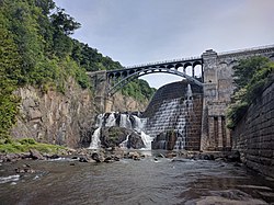
Cortlandt, New York

Last updated
Cortlandt, New York
Town of Cortlandt
Cortlandt, NY Seal.png
Westchester County New York incorporated and unincorporated areas Cortlandt highlighted.svg
Location of Cortlandt, New York
Coordinates: 41°15′41″N73°54′9″W / 41.26139°N 73.90250°W / 41.26139; -73.90250
Country United States
State New York
County Westchester
Founded1788 [1]
Government
  TypeManager-Council
  Town SupervisorRichard H. Becker (D) [2]
  Town Board
Members
Area
[4]
  Total50.02 sq mi (129.54 km2)
  Land39.26 sq mi (101.68 km2)
  Water10.76 sq mi (27.86 km2)
Elevation
318 ft (97 m)
Population
 (2010)
  Total41,592
  Estimate 
(2016) [5]
42,821
  Density1,090.76/sq mi (421.15/km2)
Time zone UTC-5 (Eastern (EST))
  Summer (DST) UTC-4 (EDT)
FIPS code 36-18410
GNIS feature ID0978871
Website townofcortlandt.com

Cortlandt is a town in Westchester County, New York, United States, located at the northwestern edge of the county, at the eastern terminus of the Bear Mountain Bridge. The town includes the villages of Buchanan and Croton-on-Hudson.

Contents

History

The Bear Mountain Bridge Road and Toll House and the Old Croton Dam are listed on the National Register of Historic Places. [6]

Cortlandt is also known for its Revolutionary War history, specifically the location of the strategic Kings Ferry between Stony Point and Verplanck's Point, which George Washington's army used to cross the Hudson on its march to Yorktown, Virginia, in 1781. John Trumbull's full-length oil portrait of Washington at Verplanck's Point exists in two versions.

Geography

The town's western borders are the Hudson River and the city of Peekskill. Its northern borders are the towns of Philipstown and Putnam Valley in Putnam County. Its eastern border is the town of Yorktown. Its southern borders are the towns of New Castle and Ossining.

According to the United States Census Bureau, the town has a total area of 50.0 square miles (129.5 km2), of which 39.3 square miles (101.7 km2) is land and 10.8 square miles (27.9 km2), or 21.51%, is water. [7]

Demographics

Historical population
CensusPop.Note
1790 1,932
1820 3,421
1830 3,84012.2%
1840 5,59245.6%
1850 7,75838.7%
1860 10,07429.9%
1870 11,69416.1%
1880 12,6648.3%
1890 15,13919.5%
1900 18,70323.5%
1910 22,25519.0%
1920 21,023−5.5%
1930 26,49226.0%
1940 11,016−58.4%
1950 14,14628.4%
1960 26,33686.2%
1970 34,39330.6%
1980 35,7053.8%
1990 37,3574.6%
2000 38,4673.0%
2010 41,5928.1%
2016 (est.)42,821 [5] 3.0%
U.S. Decennial Census [8]

At the 2000 census there were 38,467 people in 13,517 households, including 10,137 families, in the town. The population density was 969.7 inhabitants per square mile (374.4/km2). There were 14,065 housing units at an average density of 354.5 per square mile (136.9/km2). The racial makeup of the town was 88.60% White, 4.59% African American, 0.21% Native American, 2.57% Asian, 0.01% Pacific Islander, 2.35% from other races, and 1.68% from two or more races. Hispanic or Latino of any race were 7.19%. [9]

Of the 13,517 households 39.3% had children under the age of 18 living with them, 64.3% were married couples living together, 7.9% had a female householder with no husband present, and 25.0% were non-families. 21.3% of households were one person and 8.8% were one person aged 65 or older. The average household size was 2.75 and the average family size was 3.22.

The age distribution was 26.5% under the age of 18, 5.3% from 18 to 24, 30.1% from 25 to 44, 25.3% from 45 to 64, and 12.8% 65 or older. The median age was 39 years. For every 100 females, there were 95.8 males. For every 100 females age 18 and over, there were 92.7 males.

The median household income was $75,442 and the median family income was $89,053. Males had a median income of $59,949 versus $41,115 for females. The per capita income for the town was $33,432. About 2.9% of families and 4.5% of the population were below the poverty line, including 4.1% of those under age 18 and 5.1% of those age 65 or over.

Transportation

Commuter service to New York City is available via the Cortlandt train station and the Croton-Harmon train station, served by Metro-North Railroad. Croton-Harmon is also served by Amtrak.

U.S. Route 9 passes through the town along the Hudson River side.

The Appalachian Trail (AT) runs through a very small portion of the north west portion of the town near and over the Bear Mountain Bridge, which is the only section of the AT in Westchester County NY.

Government

Cortlandt is governed by a town board and the Town Supervisor is Dr. Richard Becker, who replaced Linda Puglisi as the longest-serving Town Supervisor in the 200+-year history of the town(30 years). The mayors of Buchanan and Croton are Theresa Knickerbocker and Brian Pugh, respectively. Law enforcement services in Cortlandt are provided by the New York State Police and the Westchester County Department of Public Safety. The villages of Buchanan and Croton-on-Hudson also have their own, independent police departments.

Communities and locations in Cortlandt

Related Research Articles

<span class="mw-page-title-main">Westchester County, New York</span> County in New York, United States

Westchester County is located in the U.S. state of New York. It is the seventh most populous county in the State of New York and the most populous north of New York City. According to the 2020 United States Census, the county had a population of 1,004,456, its highest decennial count ever and an increase of 55,344 (5.8%) from the 949,113 counted in 2010. Located in the Hudson Valley, Westchester covers an area of 450 square miles (1,200 km2), consisting of six cities, 19 towns, and 23 villages. Established in 1683, Westchester was named after the city of Chester, England. The county seat is the city of White Plains, while the most populous municipality in the county is the city of Yonkers, with 211,569 residents per the 2020 U.S. Census.

<span class="mw-page-title-main">Minerva, New York</span> Town in New York, United States

Minerva is a town in Essex County, New York, United States. The population was 809 at the 2010 census. The town is named after Minerva, the Roman goddess of wisdom.

<span class="mw-page-title-main">Philipstown, New York</span> Town in New York, United States

Philipstown is a town located in the western part of Putnam County, New York, United States. The population was 9,831 at the 2020 census.

<span class="mw-page-title-main">Putnam Valley, New York</span> Town in New York, United States

Putnam Valley is a town in Putnam County, New York, United States. The population was 11,809 at the 2010 census. Its location is northeast of New York City, in the southwestern part of Putnam County.Putnam Valley calls itself the "Town of Lakes".

<span class="mw-page-title-main">Halfmoon, New York</span> Town in New York, United States

Halfmoon is a town in Saratoga County, New York, United States. The population was 25,662 at the 2020 census. The town is apparently named for the shape of the lower elevation land north of the junction of the Hudson and Mohawk Rivers. It is also said to be named for Henry Hudson's ship, the Halve Maen.

<span class="mw-page-title-main">Moreau, New York</span> Town in New York, United States

Moreau is a town in Saratoga County, New York, United States. The population was 13,826 at the 2000 census. The town is located in the northeast part of the county, north of Saratoga Springs. Moreau is named after Jean Victor Moreau, a French general, who visited the area just before the town was formed. The town contains a village called South Glens Falls.

<span class="mw-page-title-main">Buchanan, New York</span> Village in New York, United States

Buchanan is a village located in the town of Cortlandt in Westchester County, New York, United States. The population was 2,230 as of the 2010 census.

<span class="mw-page-title-main">Crompond, New York</span> CDP in New York, United States

Crompond is a hamlet and census-designated place (CDP) located in the town of Yorktown in Westchester County, New York, United States. The population was 2,292 at the 2010 census.

<span class="mw-page-title-main">Croton-on-Hudson, New York</span> Village in New York, United States

Croton-on-Hudson is a village in Westchester County, New York, United States. The population was 8,327 at the 2020 United States census over 8,070 at the 2010 census. It is located in the town of Cortlandt as part of New York City's northern suburbs. The village was incorporated in 1898.

<span class="mw-page-title-main">Crugers, New York</span> Hamlet and census-designated place in Cortlandt, New York

Crugers is a hamlet and census-designated place (CDP) located in the town of Cortlandt, Westchester County, New York, United States. The population was 1,534 at the 2010 census.

<span class="mw-page-title-main">Greenburgh, New York</span> Town in New York, United States

Greenburgh is a town in western Westchester County, New York. The population was 95,397 at the time of the 2020 census.

<span class="mw-page-title-main">Mohegan Lake, New York</span> CDP in New York, United States

Lake Mohegan, commonly known as Mohegan Lake, is a census-designated place (CDP) located in the Town of Yorktown in Westchester County, New York, United States.

<span class="mw-page-title-main">New Castle, New York</span> Town in New York, United States

New Castle is a town in Westchester County, New York, United States. The population was 18,311 in the 2020 United States census, an increase over 17,569 at the 2010 census. It includes the hamlets of Chappaqua and Millwood.

<span class="mw-page-title-main">Peekskill, New York</span> City in New York, United States

Peekskill is a city in northwestern Westchester County, New York, United States, 35 miles (56 km) from New York City. Established as a village in 1816, it was incorporated as a city in 1940. It lies on a bay along the east side of the Hudson River, across from Jones Point in Rockland County. The population was 25,431 at the 2020 US census, an increase over 23,583 during the 2010 census. It is the third largest municipality in northern Westchester County, after the towns of Cortlandt and Yorktown.

<span class="mw-page-title-main">Somers, New York</span> Town in New York, United States

Somers is a town located in northern Westchester County, New York, United States. As of the 2010 census, the town had a population of 20,434. The nearby Metro-North Commuter Railroad provides service to Grand Central Terminal in Manhattan with an average commute time of 65 to 75 minutes from stations at Purdys, Goldens Bridge, Croton Falls, and Katonah.

<span class="mw-page-title-main">Verplanck, New York</span> CDP in New York, United States

Verplanck is a hamlet and census-designated place (CDP) in the town of Cortlandt, Westchester County, New York, United States. As of the 2010 census it had a population of 1,729. Both the hamlet and Verplanck's Point derive their name from the activities of the Verplanck family, established in New Amsterdam by Abraham Isaacsen Verplanck in the 1630s.

<span class="mw-page-title-main">Yorktown, New York</span> Town in New York, United States

Yorktown is a town on the northern border of Westchester County, New York, United States. A suburb of the New York City metropolitan area, it is approximately 38 miles (61 km) north of midtown Manhattan. The population was 36,569 at the 2020 U.S. Census.

<span class="mw-page-title-main">Yorktown Heights, New York</span> Census-designated place in New York, United States

Yorktown Heights is a census-designated place (CDP) in the town of Yorktown in Westchester County, New York, United States. The population was 1,781 at the 2010 census.

<span class="mw-page-title-main">Montrose, New York</span> Census-designated place & hamlet in New York, United States

Montrose is a hamlet within the town of Cortlandt, in the northwestern corner of Westchester County, New York, United States. It is located near Croton-on-Hudson and Buchanan. The rural character of the hamlet is defined by the Hudson River, numerous wooded hills and steep slopes, wetland areas and beautiful streams. As of the 2010 census, Montrose had a population of 2,731.

<span class="mw-page-title-main">Jefferson Valley, New York</span> Census-designated place in New York, United States

Jefferson Valley-Yorktown, commonly known as Jefferson Valley, is a census-designated place (CDP) located in the town of Yorktown in Westchester County, New York, United States. The population was 14,142 at the 2010 census. It is a hot spot for local shoppers, due to its Jefferson Valley Mall.

References

  1. "Town Profile - Town of Cortlandt, NY". Archived from the original on 2016-05-11. Retrieved 2016-05-31.
  2. "Town Supervisor - Town of Cortlandt, NY".
  3. "Town Board - Town of Cortlandt, NY".
  4. "2016 U.S. Gazetteer Files". United States Census Bureau. Retrieved Jul 5, 2017.
  5. 1 2 "Population and Housing Unit Estimates" . Retrieved June 9, 2017.
  6. 1 2 "National Register Information System". National Register of Historic Places . National Park Service. March 13, 2009.
  7. "Geographic Identifiers: 2010 Demographic Profile Data (G001): Cortlandt town, Westchester County, New York". U.S. Census Bureau, American Factfinder. Archived from the original on February 12, 2020. Retrieved January 29, 2013.
  8. "Census of Population and Housing". Census.gov. Retrieved June 4, 2015.
  9. "U.S. Census website". United States Census Bureau . Retrieved 2008-01-31.