Kayaderosseras

Last updated
Kayaderosseras Creek
KayaderosserasCreekApril2012.jpg
Kayaderosseras Creek looking downstream from US Route 9, April 2012
Location
Country United States
State New York
Region Upstate New York
Metropolitan area Capital District
Counties Saratoga County
Physical characteristics
Source 
  location Corinth, Saratoga County, New York
  coordinates 43°12′00″N73°55′17″W / 43.20000°N 73.92139°W / 43.20000; -73.92139 [1]
  elevation1,400 ft (430 m)
Mouth Saratoga Lake
  location
Saratoga Springs/Malta, Saratoga County, New York
  coordinates
43°02′27″N73°44′14″W / 43.04083°N 73.73722°W / 43.04083; -73.73722 Coordinates: 43°02′27″N73°44′14″W / 43.04083°N 73.73722°W / 43.04083; -73.73722 [1]
  elevation
200 ft (61 m)
Basin size195 sq mi (510 km2)
Basin features
River system Hudson River Watershed
Tributaries 
  left Mud Creek, Vly Creek, Star Brook, Geyser Brook, Bog Meadow Brook
  rightSouth Branch Kayaderosseras, Crook Brook, Glowgee Creek, Gordon Creek, Mourning Kill

The Kayaderosseras Creek, usually shortened to Kaydeross, is the largest river that lies completely within Saratoga County, New York State. It originates in the Kayaderosseras Range in the northern part of the county, passes through the towns of Corinth, Greenfield, and Milton, and serves as the boundary between the City of Saratoga Springs and the Town of Malta before emptying into Saratoga Lake.
Contents

History

The Mohawk tribe of the Iroquois Five Nations used the associated valley as a summer hunting and fishing destination. They named the creek Kayaderosseras (which translates into "Valley of the Crooked Stream") due to its tortuous course and dramatic drop in elevation. An 1887 source says that the name was derived from French terms, a Mohawk corruption of either pays arrosé, a watered country, or pays des ruisseaux, a country of streams, adapted by the Mohawk when they pushed out the previous inhabitants, the Mahican, in the 17th century. [2] :p.10

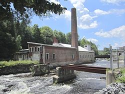
George West's "Empire Mill" along the creek at Rock City Falls Empire Mill Rock City Falls NY.jpg
George West's "Empire Mill" along the creek at Rock City Falls

The creek is best known for providing water power to a host of paper mills and a hard edge-tool factory in the 19th century. "Paper Bag King" George West established his paper bag empire on the banks of the Kayaderosseras Creek in Rock City Falls in 1862. Of the dozen paper mills situated along the creek in the late 19th century, only the Cottrell Paper Company is still in operation as of 2016. [3]

From 1898 to 1929, the 12-mile (19 km) Kaydeross Railroad, or Ballston Terminal Railroad, a trolley railroad line, closely followed the banks of the creek to serve the paper mills and Isaiah Blood's tool factory. Although this line also carried passengers, it mainly existed to carry freight.

Over-logging caused the flow of the creek to decrease dramatically in the late 19th and early 20th centuries. Today the creek possesses several popular fishing spots, especially in Rock City Falls, Milton Center, and Craneville. The principal fish is the brown trout, which is stocked. [4]

Related Research Articles

Saratoga County, New York County in New York

Saratoga County is a county in the U.S. state of New York. As of the 2019 U.S. Census estimate, the county's population was 229,863, representing a 4.7% increase from the 2010 population of 219,607, representing one of the fastest growth rates in the Northeastern United States and the fastest-growing county in Upstate New York. The county seat is Ballston Spa. Saratoga County is included in the Capital District, encompassing the Albany-Schenectady-Troy, New York Metropolitan Statistical Area.

Ballston, New York Town in New York, United States

Ballston is a town in Saratoga County, New York, United States. The population was 9,776 at the 2010 census. The name is derived from an early settler, Eliphalet Ball, a Presbyterian minister who located there from Westchester County, New York in 1770.

Ballston Spa, New York Village in New York, United States

Ballston Spa is a village and the county seat of Saratoga County, New York, United States, located southwest of Saratoga Springs. The population of the village, named after Rev. Eliphalet Ball, a Congregationalist clergyman and an early settler, was 5,409 at the 2010 census. Ballston Spa lies on the border of two towns, situated partly in the Town of Ballston and partly in the Town of Milton. The Ballston Spa School District encompassing most of the combined towns of Milton, Malta, and Ballston is often referred to locally as ‘Ballston Spa’ with the village proper being referred to as ‘The Village’ or 'Town'.

Malta, New York Town in New York, United States

Malta is a town in Saratoga County, New York, United States. The town is in the central part of the county and is south of Saratoga Springs. The population was 14,765 as of the 2010 census.

Corinth, New York Town in New York, United States

Corinth is a town in Saratoga County, New York, United States. The population was 6,531 at the 2010 census. The town contains a village also named Corinth. The town is on the northeast border of the county, north of Saratoga Springs. The town is noted as "the snowshoe capital of the world" and is home to Palmer Falls where the Hudson River passes through.

Milton (town), New York Town in New York, United States

Milton is a town in Saratoga County, New York, United States. The population was 17,103 at the 2000 census. Some believe that the town was named after the poet, John Milton, while other sources state that it is a shortening of "Mill-town" for the early mill activity.

Rensselaer and Saratoga Railroad

The Rensselaer and Saratoga Railroad was chartered on April 14, 1832. It completed 25.2 miles (40.6 km) between Troy and Ballston Spa on March 19, 1836.

Area codes 518 and 838 Telephone area codes

Area codes 518 and 838 are telephone area codes serving the northeasternmost part of Upstate New York in the United States. 518 was established as one of the original area codes during 1947. Area code 838 was added as an overlay during 2017. The two area codes cover 24 counties and 1,200 ZIP Codes. There are 493 landline exchanges and 100 wireless exchanges served by 47 carriers. The numbering plan area (NPA) it covers in New York State extends from the eastern Mohawk Valley to the Vermont border, and from the Canada–US border to south of Albany. The bulk of this NPA population is in the Capital District. Other cities in the NPA are Glens Falls, Plattsburgh, and Saratoga Springs.

West Canada Creek

The West Canada Creek is a 76-mile-long (122 km) river in upstate New York, United States. West Canada Creek is an important water way in Hamilton, Oneida, and Herkimer counties, draining the south part of the Adirondack Mountains before emptying into the Mohawk River near the Village of Herkimer. The name "Canada" is derived from an Iroquoian word for "village" (Kanata).

New York State Route 50 (NY 50) is a 31.67-mile (50.97 km) state highway in the Capital District of New York in the United States. The southern terminus of the route is at an intersection with NY 5 in Scotia. Its northern terminus is at a junction with NY 32 in the Saratoga County hamlet of Gansevoort.

New York State Route 29 (NY 29) is a state highway extending for 94.79 miles (152.55 km) across the eastern portion of the U.S. state of New York. The western terminus of the route is at NY 28 and NY 169 in Middleville, Herkimer County. The eastern terminus of the route is at NY 22 just south of Salem, Washington County. NY 29 also serves the cities of Johnstown and Saratoga Springs and intersects four major north–south roadways: NY 10, NY 30, U.S. Route 9, and U.S. Route 4.

George West (American politician)

George West was an industrialist and a U.S. Representative from New York.

Kaydeross Railroad

The Kaydeross Railroad, earlier known as the Eastern New York Railroad and Ballston Terminal Railroad, was an electric-powered trolley line that served industries along the Kayaderosseras Creek in the town of Milton, Saratoga County, New York. It was a "terminal railroad", which means it had an interchange at one end but terminated without any other interchange.

Rock City Falls, New York hamlet in New York, United States

Rock City Falls is a hamlet in the town of Milton, Saratoga County, New York, United States. The principal roads are Route 29 and Rock City Falls Road. The hamlet achieved fame as the origins of Paper Bag King George West, who established his Empire Mill there in 1862. He went on to build the Excelsior Mill next door in 1866 and a mansion across the street. The George West House was listed on the National Register of Historic Places in 2005.

Isaiah Blood

Isaiah Blood was an American farmer, manufacturer and politician from New York.

Bloodville is a hamlet of Ballston Spa, Saratoga County, New York.

Union Mill Complex United States historic place

The Union Mill Complex,, is located at the junction of Milton Avenue and Prospect Street in Ballston Spa, New York, United States. It is a complex of three late 19th-century brick buildings on a 4-acre lot, and the ruins of a dam.

The history of papermaking in New York had its beginnings in the late 18th century, at a time when linen and cotton rags were the primary source of fibers in the manufacturing process. By 1850 there were more than 106 paper mills in New York, more than in any other state. A landmark in the history of papermaking in the United States was the installation of the first Fourdrinier machine in the country at a mill in Saugerties, New York, in 1827. Papermaking from ground-wood pulp began in New York in 1869, with the establishment of the Hudson River Pulp & Paper Company in Corinth and also with the work of Illustrious Remington and his sons in Watertown. The innovation and success of the Remingtons spurred further development of the industry in the state.

Ballston Creek

Ballston Creek, also called Shenantaha Creek from the Iroquios name for Ballston Lake, is a stream in Saratoga County, New York. It originates at the north end of Ballston Lake and runs approximately six miles (9.7 km) through the towns of Ballston and Malta, descending 100 feet before exiting into Round Lake.

Saratoga Lake

Saratoga Lake is a lake in the eastern part of Saratoga County, New York. The lake is approximately 4.5 miles (7.2 km) long, about 1.5 miles (2.4 km) wide at its widest point, and about 95 feet (29 m) deep.

References

  1. 1 2 "Kayaderosseras Creek". Geographic Names Information System . United States Geological Survey . Retrieved April 28, 2016.
  2. Weise, Arthur James (1887). History of Round Lake, Saratoga County, N.Y. New York: Douglas Taylor.
  3. Starr, Timothy (2007). The Lost Industries of the Kaydeross Valley: A History of Manufacturing in Ballston Spa, New York. Instant Pub.
  4. "Fly Fishing Kayaderosseras Creek New York". Perfect Fly. Retrieved Sep 16, 2016.