Neepaulakating Creek

Last updated • 4 min readFrom Wikipedia, The Free Encyclopedia

Neepaulakating Creek
Neepaulakating Creek near headwaters Wantage Township.jpg
Neepaulakating Creek near its headwaters northwest of Lake Neepaulin.
EtymologyDerived from the names of Lake Neepaulin and Papakating Creek
Location
Country United States
State New Jersey
County Sussex
Municipality Wantage Township
Physical characteristics
Source 
  locationnorthwest of Sussex and Lake Neepaulin
  coordinates 41°13′23″N74°38′03″W / 41.22306°N 74.63417°W / 41.22306; -74.63417
  elevation640 ft (200 m)
Mouth Papakating Creek, south of Sussex
  coordinates
41°11′56″N74°36′42″W / 41.19889°N 74.61167°W / 41.19889; -74.61167
  elevation
394 ft (120 m)
Basin features
River system Papakating Creek (Wallkill River,
Rondout Creek, Hudson River)
[1] [2]

Neepaulakating Creek is a 2.4-mile long (3.8 km) tributary of Papakating Creek in Wantage Township in Sussex County, New Jersey in the United States. [1] [2] It is one of three streams feeding the Papakating Creek, a major contributor to the Wallkill River. Although the stream was dammed in the 1950s to create Lake Neepaulin as the focal point of a private residential development, the stream did not receive a name until 2002. Residents chose a name that combined elements of the names "Neepaulin" and "Papakating", and submitted a proposal to the United States Board of Geographic Names. The name was approved in 2004.

Contents

Course and watershed

Neepaulakating Creek is small stream whose headwaters are located at 640 feet (200 m) above sea level approximately 0.4 miles (0.64 km) northwest of the north end of Lake Neepaulin. [1] [2] [3] These headwaters are located a short distance south of County Route 650 (Libertyville Road) roughly halfway between the hamlet of Libertville in Wantage Township and Sussex Borough. [2] [4] The stream flows into Lake Neepaulin located at 509 ft (155 m) above sea level. [5] The man-made lake, created through damming, is the centre of a private residential development. [6] It flows southeast from the lake's dam in the southeast direction for another 1.5 miles (2.4 km) before flowing into Papakating Creek. It enters Papakating Creek at 395 feet (120 m) above sea level approximately 2.5 miles (4.0 km) upstream of that creek's junction with the Wallkill River at a location directly south of Sussex Borough along County Route 565 near the hamlet of Lewisburg in Wantage Township and near Sussex Airport. [1] [2] [3] [7]

Along with the Clove Brook and West Branch Papakating Creek, Neepaulakating Creek is one of the tributaries that form the 60.6 square miles (157 km2) watershed of Papakating Creek, a major tributary of the Wallkill River. The Papakating Creek watershed is located in the Kittatinny Valley, is underlain by dark shale and limestone of the Martinsburg Formation, and has soils of glacial origin. The topography of the Papakating Creek's watershed ranges from gentle slopes in the east to steeper slopes in the west. [8] [9] According to the New Jersey Department of Environmental Protection (NJDEP), the Papakating watershed consists of gently sloping farmland, forested land, wetlands, older individually built homes, and low-density residential development. [10]

According to NJDEP reports, two developed lake communities in the Papakating Creek watershed—Lake Neepaulin and the nearby Clove Acres Lake contribute to phosphorus loading in the waters of Papakating Creek. The phosphorus loading may originate from the runoff of fertilizer applications on residential lawns, nearby agricultural operations, or from large populations of geese that inhabit the lakes. [10]

History and naming

In the 1950s, a real estate developer dammed an unnamed stream located to the west and south of Sussex Borough and created Lake Neepaulin. The lake was the center of a planned private lakeside residential community. [6] In 2002, an organization known as Friends of Lake Neepaulin, began using "Neepaulakating Creek" as a new name for an unnamed stream that was dammed to create the lake. [3] After a review of resources available on the internet, topographic maps, and other government and historical documents, a state engineer reported there was no evidence the stream had any previous name. [11] The name chosen, Neepaulakating, was a combination of portions of the names "Neepaulin" and "Papakating". Lake Neepaulin was named after a combination of the original developers children's names. [1] [3] [12]

A formal proposal prepared by the residents was submitted to the Board of Geographic Names by Nathaniel Sajdak, described as the Outreach Coordinator of the Wallkill River Watershed and a member of Friends of Lake Neepaulin. [3] Sajdak reported to the United States Geological Survey 's Board of Geographic Names that studies such as visual and biological assessments were carried out on the unnamed stream by the Lake Neepaulin Lake Association for roughly two years, during which time they had begun to call it "Neepaulakating Creek". [3] On February 25, 2004, the Sussex County Board of Chosen Freeholders unanimously approved a resolution to support the naming, stating that the county government "defers to the Township of Wantage and concurs with the naming of the tributary as 'Neepaulakating Creek'". [13] On April 8, 2004, the Board of Geographic Names approved the proposal. [14]

See also

Related Research Articles

<span class="mw-page-title-main">Wantage Township, New Jersey</span> Township in Sussex County, New Jersey, US

Wantage Township is a township in Sussex County, in the U.S. state of New Jersey. As of the 2020 United States census, the township's population was 10,811, a decrease of 547 (−4.8%) from the 2010 census count of 11,358, which in turn reflected an increase of 971 (+9.3%) from the 10,387 counted in the 2000 census.

<span class="mw-page-title-main">Wallkill River</span> Tributary of Rondout Creek in New York and New Jersey

The Wallkill River, a tributary of the Hudson, drains Lake Mohawk in Sparta, New Jersey, flowing from there generally northeasterly 88.3 miles (142.1 km) to Rondout Creek in New York, just downstream of Sturgeon Pool, near Rosendale, with the combined flows reaching the Hudson at Kingston.

<span class="mw-page-title-main">Paulins Kill</span> River in New Jersey, United States

The Paulins Kill is a 41.6-mile (66.9 km) tributary of the Delaware River in northwestern New Jersey in the United States. With a long-term median flow rate of 76 cubic feet of water per second (2.15 m3/s), it is New Jersey's third-largest contributor to the Delaware River, behind the Musconetcong River and Maurice River. The river drains an area of 176.85 square miles (458.0 km2) across portions of Sussex and Warren counties and 11 municipalities. It flows north from its source near Newton, and then turns southwest. The river sits in the Ridge and Valley geophysical province.

<span class="mw-page-title-main">Papakating Creek</span> Creek in Sussex County, New Jersey, U.S.

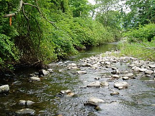
Papakating Creek is a 20.1-mile-long (32.3 km) tributary of the Wallkill River located in Frankford and Wantage townships in Sussex County, New Jersey in the United States. The creek rises in a small swamp located beneath the eastern face of Kittatinny Mountain in Frankford and its waters join the Wallkill to the east of Sussex borough.

<span class="mw-page-title-main">Fishkill Creek</span> Tributary of the Hudson River in southern Dutchess County, New York

Fishkill Creek is a tributary of the Hudson River in Dutchess County, New York, United States. At 33.5 miles (53.9 km) it is the second longest stream in the county, after Wappinger Creek. It rises in the town of Union Vale and flows generally southwest to a small estuary on the Hudson just south of Beacon. Part of its 193-square-mile (500 km2) watershed is in Putnam County to the south. Sprout Creek, the county's third-longest creek, is its most significant tributary. Whaley and Sylvan lakes and Beacon Reservoir, its largest, deepest and highest lakes, are among the bodies of water within the watershed.

<span class="mw-page-title-main">North Fork River (Missouri–Arkansas)</span> Stream in the American states of Missouri and Arkansas

The North Fork River or the North Fork of White River is a 109-mile-long (175 km) tributary of the White River, into which it flows near Norfork, Arkansas.

<span class="mw-page-title-main">Nesquehoning Creek</span> River

Nesquehoning Creek is an east flowing 14.9-mile-long (24.0 km) tributary of the Lehigh River in northeastern Pennsylvania in the United States.

<span class="mw-page-title-main">Kittatinny Valley</span>

The Kittatinny Valley is a section of the Great Appalachian Valley in Sussex and Warren counties in northwestern New Jersey that is bounded on the northwest by Kittatinny Mountain, and in the southeast by the New Jersey Highlands region. The valley is roughly 40 miles (64 km) long, with a breadth of 10 to 13 miles.

Sugarloaf Creek is a tributary of Tomhicken Creek in Luzerne County and Schuylkill County, in Pennsylvania, in the United States. It is approximately 3.5 miles (5.6 km) long and flows through Hazle Township and Black Creek Township in Luzerne County and North Union Township in Schuylkill County.

<span class="mw-page-title-main">Pond Creek (Little Wapwallopen Creek tributary)</span> River

Pond Creek is a tributary of Little Wapwallopen Creek in Luzerne County, Pennsylvania, in the United States. It is approximately 6.4 miles (10.3 km) long and flows through Slocum Township and Conyngham Township. The watershed of the creek has an area of 9.69 square miles (25.1 km2) and is part of the Lower North Branch Susquehanna drainage basin. A bridge was built over the creek in 1956. In the early 1900s, the Glen Brook Water Company planned to construct a dam on the creek. The surficial geology in the vicinity of Pond Creek includes Wisconsinan Till, alluvium, boulder alluvium, alluvial fan, and bedrock consisting of sandstone and shale, as well as some patches of wetland.

<span class="mw-page-title-main">Roaring Brook (Hunlock Creek tributary)</span> River

Roaring Brook is a tributary of Hunlock Creek in Luzerne County, Pennsylvania, in the United States. It is approximately 5.0 miles (8.0 km) long and flows through Ross Township and Hunlock Township. The watershed of the stream has an area of 6.17 square miles (16.0 km2). It has one named tributary, which is known as Lewis Run. Additionally, a dammed pond known as Harris Pond is located at the stream's headwaters. The Roaring Brook Swamp, which is listed as a Locally Significant Area on the Luzerne County Natural Areas Inventory, is also located in the watershed.

The West Branch Lackawanna River is a tributary of the Lackawanna River in Susquehanna County, Pennsylvania, in the United States. It is approximately 9.5 miles (15.3 km) long and flows through Ararat Township, Herrick Township, and Union Dale. The watershed of the river has an area of 16.8 square miles (44 km2). The river is not designated as an impaired stream and it has a high level of water quality. Lakes and wetlands in the river's watershed include Ball Lake, Fiddle Lake, Hathaway Lake, Lake Romobe, Lewis Lake, Lowe Lake, and Sink Hole Swamp. The river is also dammed by at least two dams: the Romobe Lake Dam and the Hathaway Pond Dam.

<span class="mw-page-title-main">Beth Run</span> River

Beth Run is a tributary of Bowman Creek in Luzerne County, Pennsylvania, in the United States. It is approximately 1.9 miles (3.1 km) long and flows through Ross Township and Lake Township. The watershed of the stream has an area of 2.34 square miles (6.1 km2). The surficial geology along it consists of Wisconsinan Till and alluvium. The stream's watershed is designated as a High-Quality Coldwater Fishery and a Migratory Fishery and the stream is Class A Wild Trout Waters.

<span class="mw-page-title-main">Lake Neepaulin</span> Lake of Sussex County, New Jersey, United States

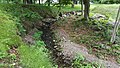
Lake Neepaulin is a small man-made freshwater lake located in Wantage Township in Sussex County, New Jersey in the United States. Located in the watershed of Papakating Creek, a tributary of the Wallkill River, the lake was created in the 1950s by damming an unnamed mountain stream as the feature of a private residential development. The stream, now known as Neepaulakating Creek, did not receive a name until 2002.

<span class="mw-page-title-main">West Branch Papakating Creek</span> Stream in the U.S. state of New Jersey

West Branch Papakating Creek is a tributary of Papakating Creek located in Frankford and Wantage townships in Sussex County, in the U.S. state of New Jersey. It covers a drainage area of 11.3 square miles (29 km2).

<span class="mw-page-title-main">Lick Run (White Deer Creek tributary)</span> River in Pennsylvania, United States

Lick Run is a tributary of White Deer Creek in Union County and Lycoming County, in Pennsylvania, in the United States. It is approximately 2.7 miles (4.3 km) long and flows through White Deer Township in Union County and Washington Township in Lycoming County. The watershed of the stream has an area of 2.10 square miles (5.4 km2). The stream has one unnamed tributary. Wild trout naturally reproduce within Lick Run, and beavers began assembling a dam on it at least once.

Butler Creek is a tributary of Nine Partners Creek in Susquehanna County, Pennsylvania, in the United States. It is approximately 12 miles (19 km) long and flows through Jackson Township, Gibson Township, and Harford Township. The watershed of the creek has an area of 20.6 square miles (53 km2). The creek has one named tributary, which is known as Little Butler Creek, and is not designated as an impaired waterbody. The creek's valley is a "beaded valley", at least in its upper reaches, and has thick deposits of till in its valley.

East Branch Saucon Creek is a tributary of Saucon Creek in Northampton County, Pennsylvania, in the United States. It is approximately 5.9 miles (9.5 km) long and flows through Lower Saucon Township and Bethlehem.

Robin Run is a dammed headwater major tributary of the Delaware River with a drainage area of 22.69 square miles that is 1.69 miles north 1.69 miles north of Mill Creek's Confluence with the Neshaminy Creek on the border of Buckingham and Wrightstown Townships), The headwaters originate in Buckingham Township, Bucks County, Pennsylvania and the stream flows generally southeast to its confluence with Mill Creek in Wrightstown Township.

Upper Greenwood Lake is a census-designated place (CDP) in Passaic and Sussex counties, in the U.S. state of New Jersey. It includes residential neighborhoods around the northern and central parts of its namesake lake. It is primarily in West Milford Township in Passaic County but extends to the northwest into Vernon Township in Sussex County. It is bordered to the west by Wawayanda State Park, to the southeast by Abram S. Hewitt State Forest, and to the northeast by the town of Warwick in Orange County, New York.

References

  1. 1 2 3 4 5 United States Geological Survey, Geographic Names Information System, Feature Detail Report for: Neepaulakating Creek. Retrieved June 26, 2015.
  2. 1 2 3 4 5 United States Geological Survey. National Hydrography Dataset high-resolution flowline data. The National Map. Retrieved June 26, 2015. Note: The upper elevation of its headwaters is approximately 640 feet above mean sea level derived from a reading of the USGS NHD topographic map. The NHD information provides the elevation the mouth at 395 feet above mean sea level. See also: United States Geological Survey, Hamburg, NJ Quadrangle USGS 1:24 Topographic Map 41074B5 and Branchville, NJ Quadrangle USGS 1:24 Topographic Map 41074B4.
  3. 1 2 3 4 5 6 Friends of Lake Neepaulin, Nathaniel Sajdak, Jennifer E. Runyon (USGS), United States Board of Geographic Names, Case Brief: Neepaulakating Creek Archived 2022-07-16 at the Wayback Machine (2002). Retrieved June 26, 2015.
  4. Google, Inc., Google Maps location for 41°13'23.3"N 74°38'01.6"W (source). Retrieved June 27, 2015.
  5. United States Geological Survey, Geographic Names Information System, Feature Detail Report for: Lake Neepaulin. Retrieved July 20, 2015.
  6. 1 2 Eric Oberhauer, "Wantage resident suing over costs of Lake Neepaulin dam", The New Jersey Herald, April 22, 2012.
  7. Google, Inc., Google Maps location for 41°11'56.7"N 74°36'40.4"W (mouth). Retrieved June 27, 2015.
  8. Avery Ala Drake Jr., Richard A. Volkert, Donald H. Monteverde, Gregory C. Herman, Hugh F. Houghton, Ronald A. Parker, and Richard F. Dalton, I2540a: Bedrock geologic map of northern New Jersey, IMAP Archived 2015-07-24 at the Wayback Machine . (Washington DC: United States Geological Survey, 1997). Retrieved 22 July 2015.
  9. New Jersey Department of Environmental Protection, Division of Watershed Management, Amendment to the Sussex County Water Quality Management Plan: Total Maximum Daily Load to Address Phosphorus in the Clove Acres Lake and Papakating Creek Northwest Water Region (2004), 9, 15. Retrieved June 26, 2015.
  10. 1 2 New Jersey Department of Environmental Protection, State Development & Redevelopment Plan. Plan Endorsement Opportunities & Constraints: Analysis for Township of Frankford, Sussex County (2009), 14, 16. Retrieved June 26, 2015.
  11. Correspondence from William P. Graff (NJDEP) to Roger L. Payne (USGS) (September 9, 2002). Retrieved June 26, 2015.
  12. E-mail corresponsdence Jim Rementer (Lenape Language Project) to Jennifer E. Runyon, USGS BGN Archived 2022-07-16 at the Wayback Machine (March 24, 2004). Retrieved June 26, 2015.
  13. Sussex County Board of Chosen Freeholders, Resolution Re: Support of the submission of a proposal by the Township of Wantage to the U.S. Board on Geographic Names regarding the naming of a tributary in Sussex County "Neepaulakating Creek" (February 25, 2004). Retrieved June 26, 2015.
  14. Letter from Roger L. Payne (USGS) to James L. Doherty (Wantage Township Administrator Clerk) (April 30, 2004). Retrieved June 26, 2015. Quote: "U.S. Board on Geographic Names, at its April 8, 2004, meeting, approved the proposal to name an unnamed stream in Sussex County, Neepaulakating Creek. This decision was made in agreement with the findings and recommendations of your office, the government of Sussex County, and the New Jersey Board on Geographic Names."