
Schoharie County is a county in the U.S. state of New York. As of the 2010 census, the population was 32,749, making it the state's fifth-least populous county. The county seat is Schoharie. "Schoharie" comes from a Mohawk word meaning "floating driftwood."

Esperance is a town in Schoharie County, New York, United States. The population was 2,043 at the 2000 census. The town was given the name of the principal village, which was named for "hope" in French.

Schoharie is a village in Schoharie County, New York, United States. The population was 922 at the 2010 census. It is the county seat of Schoharie County. The name is a native word for driftwood.
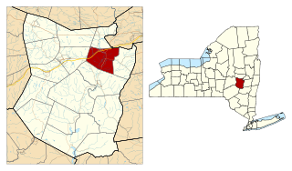
Schoharie is a town in Schoharie County, New York. The population was 3,299 at the 2000 census.

Schoharie Creek in New York, flows north 93 miles (150 km) from the foot of Indian Head Mountain in the Catskills through the Schoharie Valley to the Mohawk River. It is twice impounded north of Prattsville to create New York City's Schoharie Reservoir and the Blenheim-Gilboa Power Project.
New York State Route 443 (NY 443) is an east–west state highway in the Capital District of New York in the United States. The route begins at an intersection with NY 30 in the town of Schoharie and ends 33.44 miles (53.82 km) later at a junction with U.S. Route 9W (US 9W) and US 20 in the city of Albany. It ascends the Helderberg Escarpment in the towns of Berne and New Scotland. Within the town of Bethlehem and the city of Albany, NY 443 is known as Delaware Avenue.
New York State Route 30 (NY 30) is a state highway in the central part of New York in the United States. It extends for 300.71 miles (483.95 km) from an interchange with NY 17 in the Southern Tier to the US–Canada border in the state's North Country, where it continues into Quebec as Route 138. On a regional level, the route serves to connect the Catskill Park to the Adirondack Park. In the latter, NY 30 is known as the Adirondack Trail. Aside from the state parks, the route serves the city of Amsterdam and several villages.

The Schoharie Reservoir is a reservoir in the Catskill Mountains of New York State that was created to be one of 19 reservoirs that supplies New York City with water. It was created by impounding Schoharie Creek. Portions of it lie in the towns of Conesville and Gilboa in Schoharie County, Roxbury in Delaware County, and Prattsville in Greene County.
New York State Route 30A (NY 30A) is a 34.86-mile-long (56.10 km) state highway in the Capital District of New York in the United States. It serves as a westerly alternate route of NY 30 from near the Schoharie County village of Schoharie to the Fulton County hamlet of Riceville, 1 mile (1.6 km) south of the village of Mayfield. While NY 30 heads generally north–south between the two locations and passes through Amsterdam, NY 30A veers west to serve the villages of Fonda and Fultonville and the cities of Johnstown and Gloversville. Along the way, it connects to several major east–west highways, including U.S. Route 20 (US 20) in Esperance and the New York State Thruway in Fultonville.

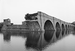
Old Blenheim Bridge was a wooden covered bridge that spanned Schoharie Creek in North Blenheim, New York, United States. With an open span of 210 feet (64 m), it had the second longest span of any surviving single-span covered bridge in the world. The 1862 Bridgeport Covered Bridge in Nevada County, California, currently undergoing repairs due to 1986 flooding is longer overall at 233 feet (71 m) but is argued to have a 208 feet (63 m) clear span. The bridge, opened in 1855, was also one of the oldest of its type in the United States. It was destroyed by flooding resulting from Tropical Storm Irene in 2011. Rebuilding of the bridge commenced in 2017 and was completed in 2018.
Schoharie Crossing State Historic Site, also known as Erie Canal National Historic Landmark, is a historic district that includes the ruins of the Erie Canal aqueduct over Schoharie Creek, and a 3.5-mile (5.6 km) long part of the Erie Canal, in the towns of Glen and Florida within Montgomery County, New York. It was the first part of the old canal to be designated a National Historic Landmark, prior to the designation of the entire New York State Barge Canal as a NHL in 2017.

Black Dome is a mountain located in Greene County, New York. The mountain is the highest peak of the Blackhead Mountains range of the Catskills. Black Dome is flanked to the east by Blackhead, and to the west by Thomas Cole Mountain.

The Schoharie Creek Bridge was a New York State Thruway bridge over the Schoharie Creek near Fort Hunter and the Mohawk River in New York State. On April 5, 1987 it collapsed due to bridge scour at the foundations after a record rainfall. The collapse killed ten people. The replacement bridge was completed and fully open to traffic on May 21, 1988.

Catskill Creek is a 46.0-mile-long (74.0 km) tributary of the Hudson River that drains the northeastern Catskill Mountains of the U.S. State of New York. From its source at Franklinton Vlaie in Schoharie County it flows southeast through parts of Albany County and Greene County to its mouth at the village of Catskill on the Hudson River.
Fox Creek is a 24.8-mile-long (39.9 km) tributary of Schoharie Creek in Schoharie and Albany counties in the U.S. state of New York. It rises in the southeastern part of the town of Berne, west of the Helderberg Mountains, and flows west, passing through the hamlets of East Berne, Bensons Corner, Berne, and West Berne, continuing through the town of Wright, where it passes the hamlets of Gallupville and Shutter Corners before entering the town of Schoharie, where it flows into Schoharie Creek near the hamlet of Vroman Corners. Fox Creek is part of the Hudson River watershed, Via Schoharie Creek and the Mohawk River.

Cobleskill Creek starts at Pine Mountain west of West Richmondville and flows east-northeast before converging with Schoharie Creek in Central Bridge, New York. The creek flows through the village of Richmondville, New York and Cobleskill, New York.
East Kill, a 16-mile-long (26 km) tributary of Schoharie Creek, flows across the town of Jewett, New York, United States, from its source on Stoppel Point. Ultimately its waters reach the Hudson River via the Mohawk. Since it drains into the Schoharie upstream of Schoharie Reservoir, it is part of the New York City water supply system. East Kill drains the southern slopes of the Blackhead Mountains, which include Thomas Cole Mountain, Black Dome, and Blackhead Mountain, the fourth-, third-, and fifth-highest peaks in the Catskills, respectively.

The West Kill, an 11-mile-long (18 km) tributary of Schoharie Creek, flows through the town of Lexington, New York, United States, from its source on Hunter Mountain, the second-highest peak of the Catskill Mountains. Ultimately its waters reach the Hudson River via the Mohawk. Since it drains into the Schoharie upstream of Schoharie Reservoir, it is part of the New York City water supply system. It lends its name to both a mountain to its south and a small town midway along its length.

Batavia Kill is a 21-mile-long (34 km) tributary of Schoharie Creek, that flows across the towns of Windham, Ashland and Prattsville in the U.S. state of New York. Its waters reach the Hudson River via Schoharie Creek and the Mohawk River. Since it drains into the Schoharie upstream of Schoharie Reservoir, it is part of the New York City water supply system. From the source to Maplecrest, Batavia Kill drains the northern slopes of the Blackhead Mountains, which include Thomas Cole Mountain, Black Dome, and Blackhead Mountain, the fourth-, third-, and fifth-highest peaks in the Catskills, respectively.

