Whitestown, New York

Last updated

Whitestown, New York
Whitestown, NY Seal.jpeg
Oneida County New York incorporated and unincorporated areas Whitestown highlighted.svg
Location in Oneida County and the state of New York.
Coordinates: 43°07′24″N75°22′35″W / 43.12333°N 75.37639°W / 43.12333; -75.37639
CountryUnited States
State New York
County Oneida
Government
  Type Town Council
   Town Supervisor Shaun J Kaleta ()
   Town Council
Members' List
Area
[1]
  Total27.32 sq mi (70.76 km2)
  Land27.32 sq mi (70.75 km2)
  Water0.00 sq mi (0.00 km2)
Elevation
[2]
479 ft (146 m)
Population
 (2010)
  Total18,667
  Estimate 
(2016) [3]
18,474
  Density676.26/sq mi (261.10/km2)
Time zone UTC-5 (Eastern (EST))
  Summer (DST) UTC-4 (EDT)
ZIP code
13492
Area code 315
FIPS code 36-81754 [4]
GNIS feature ID0979638 [2]
Website www.whitestown.net

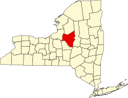
Whitestown is a town in Oneida County, New York, United States. The population was 18,667 at the 2010 census. The name is derived from Judge Hugh White, an early settler. The town is immediately west of Utica and the New York State Thruway (Interstate 90) passes across the town. The offices of the town of Whitestown are in the Village of Whitesboro.

Contents

History

The town, part of the Sadaquada Patent, was settled in 1784. The Town of Whitestown was formed in 1788, before the creation of Oneida County, with a size of 12 million acres (49,000 km2). Whitestown was founded by Hugh White after he scouted the land in 1784 by way of traveling the Mohawk River. On June 5, 1784, White and his family came upon the mouth of the Sauquoit Creek and settled in the forests that would become Whitestown. White was also the forerunner for the creation of Oneida County in the 1790s. [5] [6]

Whitestown is known as the "Mother of Towns" because of the many towns and counties formed from its expanse. The Town of Paris and the Town of Steuben were formed from Whitestown in 1792. The Town of Cazenovia was formed in 1793. The Town of Augusta was formed in 1798. Utica was formed in 1817. The Town of New Hartford was formed from Whitestown in 1827.

The Oneida Institute, the first mixed-"race" educational institution in the United States, operated in Whitesboro from 1827 to 1843.

Geography

According to the United States Census Bureau, the town has a total area of 27.2 square miles (70 km2), of which 27.2 square miles (70 km2) is land and 0.04% is water.

The town is west of the City of Utica and the northern border is defined by the Mohawk River.

Oriskany Creek flows northward through the town to the Mohawk River.

Demographics

Historical population
CensusPop.Note
1800 4,212
1810 4,91216.6%
1820 5,2196.3%
1830 4,419−15.3%
1840 5,15616.7%
1850 5,82012.9%
1860 4,367−25.0%
1870 4,339−0.6%
1880 4,4983.7%
1890 5,15514.6%
1900 6,23521.0%
1910 7,79825.1%
1920 10,18330.6%
1930 11,81816.1%
1940 11,580−2.0%
1950 12,6869.6%
1960 19,18551.2%
1970 21,38211.5%
1980 20,150−5.8%
1990 18,985−5.8%
2000 18,635−1.8%
2010 18,6670.2%
2020 18,118−2.9%
2022 (est.)17,870 [3] −1.4%
U.S. Decennial Census [7]

As of the census [4] of 2000, there were 18,635 people, 7,544 households, and 5,024 families living in the town. The population density was 685.2 inhabitants per square mile (264.6/km2). There were 7,945 housing units at an average density of 292.1 per square mile (112.8/km2). The racial makeup of the town was 97.27% White, 1.18% African American, 0.09% Native American, 0.48% Asian, 0.01% Pacific Islander, 0.28% from other races, and 0.69% from two or more races. Hispanic or Latino of any race were 1.32% of the population.

There were 7,544 households, out of which 28.8% had children under the age of 18 living with them, 52.1% were married couples living together, 11.2% had a female householder with no husband present, and 33.4% were non-families. 29.3% of all households were made up of individuals, and 14.8% had someone living alone who was 65 years of age or older. The average household size was 2.39 and the average family size was 2.96.

In the town, the population was spread out, with 22.8% under the age of 18, 7.3% from 18 to 24, 27.4% from 25 to 44, 23.9% from 45 to 64, and 18.5% who were 65 years of age or older. The median age was 40 years. For every 100 females, there were 93.2 males. For every 100 females age 18 and over, there were 90.0 males.

The median income for a household in the town was $40,084, and the median income for a family was $49,798. Males had a median income of $36,553 versus $24,942 for females. The per capita income for the town was $19,507. About 7.0% of families and 9.1% of the population were below the poverty line, including 14.7% of those under age 18 and 9.6% of those age 65 or over.

Places of interest

Communities and locations in Whitestown

Villages of Whitestown

Below are the villages and hamlets of Whitestown. [11]

Related Research Articles

<span class="mw-page-title-main">Herkimer County, New York</span> County in New York, United States

Herkimer County is a county in the U.S. state of New York. As of the 2020 census, the population was 60,139. Its county seat is Herkimer. The county was created in 1791 north of the Mohawk River out of part of Montgomery County. It is named after General Nicholas Herkimer, who died from battle wounds in 1777 after taking part in the Battle of Oriskany during the Revolutionary War.

<span class="mw-page-title-main">Oneida County, New York</span> County in New York, United States

Oneida County is a county in the state of New York, United States. As of the 2020 census, the population was 232,125. The county seat is Utica. The name is in honor of the Oneida, one of the Five Nations of the Iroquois League or Haudenosaunee, which had long occupied this territory at the time of European encounter and colonization. The federally recognized Oneida Indian Nation has had a reservation in the region since the late 18th century, after the American Revolutionary War.

<span class="mw-page-title-main">Danube, New York</span> Town in New York, United States

Danube is a town in Herkimer County, New York, United States. The population was 1,039 at the 2010 census. Early Palatine German immigrants in the eighteenth century named the town after the Danube River in Europe.

<span class="mw-page-title-main">Schuyler, New York</span> Town in Herkimer County, New York, US

Schuyler is a town in Herkimer County, New York, United States. The population was 3,420 at the 2010 census. The town is in the western part of Herkimer County and is east of Utica.

<span class="mw-page-title-main">Augusta, New York</span> Town in New York, United States

Augusta is a town in Oneida County, New York, United States. The population was 2,020 at the 2010 census.

<span class="mw-page-title-main">Deerfield, New York</span> Town in New York, United States

Deerfield is a town in Oneida County, New York, United States. The population was 4,273 at the 2010 census.

<span class="mw-page-title-main">Marcy, New York</span> Town in New York, United States

Marcy is a town in Oneida County, New York, United States. The population was 8,982 at the 2010 census. The town was named after Governor William L. Marcy. It lies between the cities of Rome and Utica. The Erie Canal passes through the southern part of the town.

<span class="mw-page-title-main">Marshall, New York</span> Town in New York, United States

Marshall is a town in Oneida County, New York, United States. The population was 2,131 at the 2010 census.

<span class="mw-page-title-main">New York Mills, New York</span> Village in New York, United States

New York Mills is a village in Oneida County, New York, United States. The population was 3,327 at the 2010 census.

<span class="mw-page-title-main">Oriskany, New York</span> Village in New York, United States

Oriskany is a village in Oneida County, New York, United States. The population was 1,400 at the 2010 census. The name is derived from the Iroquois word for "nettles".

<span class="mw-page-title-main">Waterville, New York</span> Village in New York, United States

Waterville is a village in Oneida County, New York, United States. According to the 2010 census, its population was 1,583.

<span class="mw-page-title-main">Westmoreland, New York</span> Town in New York, United States

Westmoreland is a town in Oneida County, New York, United States. The population was 6,138 at the 2010 census.

<span class="mw-page-title-main">Whitesboro, New York</span> Village in New York, United States

Whitesboro is a village in Oneida County, New York, United States. The population was 3,772 at the 2010 census. The village is named after Hugh White, an early settler.

<span class="mw-page-title-main">Yorkville, Oneida County, New York</span> Village in New York, United States

Yorkville is a village in Oneida County, New York, United States. The population was 2,689 at the 2010 census.

<span class="mw-page-title-main">Herkimer (town), New York</span> Town in New York, United States

Herkimer is a town in Herkimer County, New York, United States, southeast of Utica. It is named after Nicholas Herkimer. The population was 10,175 at the 2010 census.

<span class="mw-page-title-main">Canajoharie, New York</span> Town in New York, United States

Canajoharie is a town in Montgomery County, New York, United States. The population was 3,730 in 2010. Canajoharie is located south of the Mohawk River on the southern border of the county. The Erie Canal passes along the northern town line. There is also a village of Canajoharie in the town. Both are east of Utica and west of Amsterdam.

<span class="mw-page-title-main">New Hartford, New York</span> Town in New York, United States

New Hartford is a town in Oneida County, New York, United States. As of the 2010 census, the town population was 22,166. The name of New Hartford was provided by a settler family from Hartford, Connecticut.

<span class="mw-page-title-main">New York State Route 5A</span> State highway in Oneida County, New York, US

New York State Route 5A (NY 5A) is an east–west state highway located within Oneida County, New York, in the United States. It is a 5.59-mile (9.0 km) alternate route of NY 5 between New Hartford and downtown Utica. At its eastern end, NY 5A becomes NY 5S at an interchange with Interstate 790 (I-790), NY 5, NY 8, and NY 12. The route is four lanes wide and passes through mostly commercial areas. When NY 5A was assigned in the mid-1930s, it ended at Yorkville, a village roughly midway between NY 5 in New Hartford and downtown Utica. It was extended to its present length in the 1940s.

<span class="mw-page-title-main">New York State Route 291</span> State highway in Oneida County, New York, US

New York State Route 291 (NY 291) is a state highway in Oneida County, New York, in the United States. The route extends from an intersection with NY 69 in the town of Whitestown to a junction with NY 365 in the extreme northern tip of the town of Marcy, near the hamlet of Stittville. It is a two-lane highway its entire length. NY 291 meets NY 49, the Utica–Rome Expressway, at an interchange roughly 1 mile (1.6 km) northeast of NY 69. NY 291 provides access to the Marcy Correctional Facility and Mid-State Correctional Facility, both in Marcy.

<span class="mw-page-title-main">Utica–Rome metropolitan area</span> Metropolitan area in New York, United States

The Utica–Rome Metropolitan Statistical Area, as defined by the United States Census Bureau, is an area consisting of two counties in Central New York anchored by the cities of Utica and Rome. As of the 2020 census, the MSA had a population of 292,264.

References

  1. "2016 U.S. Gazetteer Files". United States Census Bureau. Retrieved July 5, 2017.
  2. 1 2 U.S. Geological Survey Geographic Names Information System: Whitestown, New York
  3. 1 2 "Population and Housing Unit Estimates" . Retrieved June 9, 2017.
  4. 1 2 "U.S. Census website". United States Census Bureau . Retrieved January 31, 2008.
  5. "Oneida County Historical Society".
  6. ELLIS, DAVID MALDWYN (January 1, 1984). "Whitestown: From Yankee Outpost to Cradle of Reform". New York History. 65 (1): 32–59. JSTOR   23174769.
  7. "Census of Population and Housing". Census.gov. Retrieved June 4, 2015.
  8. "World Airline Directory." Flight International . 6 May 1971. 637.
  9. "Zoning Map." Town of Whitestown. Retrieved on January 21, 2010.
  10. "Oneida County Historical Society".
  11. "History of Whitestown, NY".