Holland Patent, New York

Last updated

Holland Patent, New York
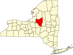
Oneida County New York incorporated and unincorporated areas Holland Patent highlighted.svg
Location in Oneida County and the state of New York
Coordinates: 43°14′31″N75°15′25″W / 43.24194°N 75.25694°W / 43.24194; -75.25694
CountryUnited States
State New York
County Oneida
Government
  MayorThomas C. Furlong
  Deputy MayorA. Scott Rosenburgh
Area
[1]
  Total0.51 sq mi (1.32 km2)
  Land0.51 sq mi (1.31 km2)
  Water0.00 sq mi (0.01 km2)
Elevation
640 ft (195 m)
Population
 (2020)
  Total416
  Density822.13/sq mi (317.72/km2)
Time zone UTC-5 (Eastern (EST))
  Summer (DST) UTC-4 (EDT)
ZIP code
13354
Area code 315
FIPS code 36-35144
GNIS feature ID0952992
Website Village website

Holland Patent is a village in Oneida County, New York, United States. The population was 416 at the 2020 census. The village is named after a land grant, and is in the western part of the town Trenton at the junction of routes 274, 291, and 365.

Contents

History

In 1797, the village of Holland Patent was established by Gerrit Boon, an agent of the Holland Land Company to help develop and sell land that had been purchased as investments.

The Holland Patent Stone Churches Historic District was listed on the National Register of Historic Places in 1991. [2] The Holland Patent Railroad Station was listed in 2000. [2]

Geography

Holland Patent is located at 43°14′31″N75°15′25″W / 43.24194°N 75.25694°W / 43.24194; -75.25694 (43.241819, -75.257057). [3]

According to the United States Census Bureau, the village has a total area of 0.5 square miles (1.3 km2), of which 0.5 square miles (1.3 km2) is land and 2.04% is water.

Demographics

Historical population
CensusPop.Note
1870 320
1880 40125.3%
1890 4061.2%
1900 352−13.3%
1910 337−4.3%
1920 328−2.7%
1930 3372.7%
1940 38815.1%
1950 4003.1%
1960 53834.5%
1970 5563.3%
1980 534−4.0%
1990 411−23.0%
2000 46112.2%
2010 458−0.7%
2020 416−9.2%
U.S. Decennial Census [4]

As of the census [5] of 2000, there were 461 people, 201 households, and 129 families residing in the village. The population density was 958.8 inhabitants per square mile (370.2/km2). There were 227 housing units at an average density of 472.1 per square mile (182.3/km2). The racial makeup of the village was 98.48% White, 0.22% Asian, 0.22% from other races, and 1.08% from two or more races. Hispanic or Latino people of any race were 0.65% of the population.

There were 201 households, out of which 31.8% had children under the age of 18 living with them, 49.8% were married couples living together, 10.9% had a female householder with no male present, and 35.8% were non-families. 31.3% of all households were made up of individuals, and 9.5% had someone living alone who was 65 years of age or older. The average household size was 2.29 and the average family size was 2.91.

In the village, the population was spread out, with 23.6% under the age of 18, 9.3% from 18 to 24, 27.5% from 25 to 44, 24.3% from 45 to 64, and 15.2% who were 65 years of age or older. The median age was 39 years. For every 100 females, there were 104.9 males. For every 100 females age 18 and over, there were 93.4 males.

The median income for a household in the village was $42,167, and the median income for a family was $51,667. Males had a median income of $30,000 versus $27,917 for females. The per capita income for the village was $21,864. About 3.2% of families and 4.1% of the population were below the poverty line, including 2.6% of those under age 18 and 3.8% of those age 65 or over.

Notable person

First Lady Rose Cleveland grew up in Holland Patent.[ citation needed ]

See also

Related Research Articles

<span class="mw-page-title-main">Thomasboro, Illinois</span> Village in Illinois, United States

Thomasboro is a village in Champaign County, Illinois, United States. The population was 1,034 at the 2020 census.

<span class="mw-page-title-main">Level Park–Oak Park, Michigan</span> Census-designated place & unincorporated community in Michigan, United States

Level Park–Oak Park is a census-designated place for statistical purposes in Calhoun County in the U.S. state of Michigan. The CDP population was 3,260 at the 2020 census. The CDP is immediately northwest of the city of Battle Creek and is part of the Battle Creek Metropolitan Statistical Area.

<span class="mw-page-title-main">Deweese, Nebraska</span> Village in Clay County, Nebraska, United States

Deweese is a village in Clay County, Nebraska, United States. The population was 43 at the 2020 census. It is part of the Hastings, Nebraska Micropolitan Statistical Area.

Masonville is a town in Delaware County, New York, United States. The population was 1,239 at the 2020 census. The town is in the western part of the county.

<span class="mw-page-title-main">Cold Brook, New York</span> Village in New York, United States

Cold Brook is a village in Herkimer County, New York. The population was 329 at the time of the 2010 census. It is named after a stream passing through the village. The village is located in the south part of the town of Russia and is northeast of Utica.

Lyons Falls is a village in Lewis County, New York, United States. The population was 566 at the 2010 census. The village is on the border of the towns of West Turin and Lyonsdale. It is at the junction of state Routes 12 and 12D, approximately 14 miles (23 km) south of Lowville, the county seat.

<span class="mw-page-title-main">Sylvan Beach, New York</span> Village in New York, United States

Sylvan Beach is a village in Oneida County, New York, United States; in the southeastern end of the Town of Vienna. It is twenty-two miles west of Rome. At the 2010 census, the population of Sylvan Beach was 897.

<span class="mw-page-title-main">Trenton, New York</span> Town in New York, United States

Trenton is a town in Oneida County, New York, United States. The population was 4,297 at the 2020 census.

<span class="mw-page-title-main">Holland, Ohio</span> Village in Ohio, United States

Holland is a village in eastern Springfield Township, Lucas County, Ohio, United States. Holland is a suburb of Toledo. The population was 1,664 at the 2020 census.

<span class="mw-page-title-main">Hometown, Pennsylvania</span> CDP in Pennsylvania, United States

Hometown is a village in Rush Township, Schuylkill County, Pennsylvania, United States that sits astride a crossing point between important transportation corridors. The population was 1,399 at the 2000 census, and excepting for the area near the east–west PA 54 running mostly parallel to the tracks of the Reading, Blue Mountain, and Northern Railroad — once the important east-west shortline Nesquehoning & Mahanoy Railroad — and the PA 54 junction with PA 309.

<span class="mw-page-title-main">Cheriton, Virginia</span> Town in Virginia, United States

Cheriton is a town in Northampton County, Virginia, United States. The population was 486 at the 2020 census.

<span class="mw-page-title-main">Matoaka, West Virginia</span> Census-designated place in West Virginia, United States

Matoaka is a census-designated place in Mercer County, West Virginia, United States. The population was 173 at the 2020 census. It is part of the Bluefield, WV-VA micropolitan area which has a population of 100,093. This town is named for Chief Powhatan's daughter Matoaka who was better known by her nickname "Pocahontas". Matoaka became an unincorporated town when it voted to dissolve its charter in May 2018.

<span class="mw-page-title-main">Greene (village), New York</span> Village in New York, United States

Greene is a village in Chenango County, New York, United States. The population was 1,580 as of the 2010 census. The village is named after General Nathanael Greene. It is within the town of Greene and is northeast of Binghamton.

<span class="mw-page-title-main">Hancock (village), New York</span> Village in New York, United States

Hancock is a village in Delaware County, New York, United States. The population was 908 at the 2020 census. The village is in the west part of the town of Hancock at the junction of NY Routes 17 and 97.

<span class="mw-page-title-main">DeRuyter (village), New York</span> Village in New York, United States

DeRuyter is a village located in the Town of DeRuyter in Madison County, New York, United States. The population was 558 at the 2010 census. The village and town are named after Michiel Adriaenszoon de Ruyter, a famous admiral in the Dutch navy.

<span class="mw-page-title-main">Madison (village), New York</span> Village in New York, United States

Madison is a village in Madison County, New York, United States. The population was 305 at the 2010 census. The village and its town are named after President James Madison.

<span class="mw-page-title-main">Bridgewater (CDP), New York</span> Hamlet and CDP in New York, United States

Bridgewater is a hamlet in Oneida County, New York, United States. The population was 470 at the 2010 census.

<span class="mw-page-title-main">New Hartford (village), New York</span> Village in New York, United States

New Hartford is a village in Oneida County, New York, United States. The population was 1,859 at the 2020 census. The name was provided by early settlers from New Hartford, Connecticut. It is located inside the town New Hartford, near the border with Utica.

<span class="mw-page-title-main">Remsen (village), New York</span> Village in New York, United States

Remsen is a village in Oneida County, New York, United States. The population was 431 at the 2020 census.

<span class="mw-page-title-main">Vernon (village), New York</span> Village in New York, United States

Vernon is a village in Oneida County, New York, United States. The population was 1,172 at the 2010 census.

References

  1. "ArcGIS REST Services Directory". United States Census Bureau. Retrieved September 20, 2022.
  2. 1 2 "National Register Information System". National Register of Historic Places . National Park Service. March 13, 2009.
  3. "US Gazetteer files: 2010, 2000, and 1990". United States Census Bureau. February 12, 2011. Retrieved April 23, 2011.
  4. "Census of Population and Housing". Census.gov. Retrieved June 4, 2015.
  5. "U.S. Census website". United States Census Bureau . Retrieved January 31, 2008.