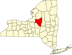
Kirkland, New York | |
---|---|
Coordinates: 43°2′53″N75°23′2″W / 43.04806°N 75.38389°W | |
Country | United States |
State | New York |
County | Oneida |
Government | |
• Type | Town Council |
• Town Supervisor | Robert J. Meelan (D) |
• Town Council | Members' List |
Area | |
• Total | 33.81 sq mi (87.57 km2) |
• Land | 33.76 sq mi (87.44 km2) |
• Water | 0.05 sq mi (0.13 km2) |
Elevation | 689 ft (210 m) |
Population (2010) | |
• Total | 10,315 |
• Estimate (2016) [2] | 10,105 |
• Density | 299.30/sq mi (115.56/km2) |
Time zone | UTC-5 (Eastern (EST)) |
• Summer (DST) | UTC-4 (EDT) |
ZIP code | 13323 |
Area code | 315 |
FIPS code | 36-39804 |
GNIS feature ID | 0979120 |
Website | Town website |
Kirkland is a town in Oneida County, New York, United States. The population was 10,075 at the 2020 census. The town is named after Samuel Kirkland, [3] a missionary among the Oneidas. [4]
The Town of Kirkland is southwest of Utica. In 1829, part of Kirkland was used to form the newer Town of Marshall.
Hamilton College is located in the western part of the town.
Clinton is the only village in the town of Kirkland.
The first settlement occurred around 1787 near the present village of Clinton. The Town of Kirkland was established in 1827 from the Town of Paris. The land of the town belonged to the Kirkland Patent, Brothertown Patent, and Coxe Patent.
The Rev. Asahel Norton Homestead was listed on the National Register of Historic Places in 1985. [5]
According to the United States Census Bureau, the town has a total area of 33.9 square miles (88 km2), of which 33.8 square miles (88 km2) is land and 0.1 square miles (0.26 km2) (0.21%) is water.
The Oriskany Creek flows through the town.
Census | Pop. | Note | %± |
---|---|---|---|
1830 | 2,509 | — | |
1840 | 2,984 | 18.9% | |
1850 | 3,421 | 14.6% | |
1860 | 4,185 | 22.3% | |
1870 | 4,912 | 17.4% | |
1880 | 4,984 | 1.5% | |
1890 | 4,852 | −2.6% | |
1900 | 4,545 | −6.3% | |
1910 | 4,333 | −4.7% | |
1920 | 4,744 | 9.5% | |
1930 | 5,059 | 6.6% | |
1940 | 5,211 | 3.0% | |
1950 | 6,164 | 18.3% | |
1960 | 7,978 | 29.4% | |
1970 | 9,688 | 21.4% | |
1980 | 10,334 | 6.7% | |
1990 | 10,153 | −1.8% | |
2000 | 10,138 | −0.1% | |
2010 | 10,315 | 1.7% | |
2020 | 10,075 | −2.3% | |
U.S. Decennial Census [6] |
At the 2000 census there were 10,138 people, 3,419 households, and 2,229 families living in the town. The population density was 300.0 inhabitants per square mile (115.8/km2). There were 3,591 housing units at an average density of 106.3 per square mile (41.0/km2). The racial makeup of the town was 96.32% White, 1.20% African American, 0.07% Native American, 1.21% Asian, 0.03% Pacific Islander, 0.27% from other races, and 0.90% from two or more races. Hispanic or Latino of any race were 1.32%. [7]
Of the 3,419 households 30.4% had children under the age of 18 living with them, 53.1% were married couples living together, 8.9% had a female householder with no husband present, and 34.8% were non-families. 29.4% of households were one person and 12.6% were one person aged 65 or older. The average household size was 2.39 and the average family size was 3.00.
The age distribution was 20.0% under the age of 18, 20.9% from 18 to 24, 21.2% from 25 to 44, 22.2% from 45 to 64, and 15.7% 65 or older. The median age was 36 years. For every 100 females, there were 91.4 males. For every 100 females age 18 and over, there were 86.8 males.
The median household income was $45,875 and the median family income was $58,958. Males had a median income of $40,058 versus $27,265 for females. The per capita income for the town was $21,164. About 3.9% of families and 7.7% of the population were below the poverty line, including 9.6% of those under age 18 and 4.9% of those age 65 or over.
Most of Kirkland is in Clinton Central School District. Portions are in New Hartford Central School District,, Sauquoit Valley Central School District,, Sherrill City School District,, and Waterville Central School District. [13]
Beekmantown is a town in Clinton County, New York, United States. The population was 5,545 at the 2010 census. The town name is that of William Beekman, an original landowner. It is on the eastern border of the county, just north of Plattsburgh.
Annsville is a town in Oneida County, New York, United States. At the 2010 census the town population was 3,012. The town is named after Ann Bloomfield, wife of a founder.
Augusta is a town in Oneida County, New York, United States. The population was 2,021 at the 2020 census.
Ava is a town in Oneida County, New York, United States. The population was 680 at the 2020 census.
Clark Mills is a hamlet in Oneida County, New York, United States. The population was 1,905 at the 2010 census.
Clinton is a village in Oneida County, New York, United States. The population was 1,942 at the 2010 census, declining to 1,683 in the 2020 census, 13% decline). It was named for George Clinton, the first Governor of New York.
Marshall is a town in Oneida County, New York, United States. The population was 1,966 at the 2020 census.
Paris is a town in Oneida County, New York, United States. The town is in the southeast part of the county and is south of Utica. The population was 4,332 at the 2020 census. The town was named after an early benefactor, Colonel Isaac Paris.
Sangerfield is a town in Oneida County, New York, United States. The population was 2,561 at the 2010 census. The town is named after Jedediah Sanger, an early settler.
Trenton is a town in Oneida County, New York, United States. The population was 4,297 at the 2020 census.
Verona is a town in southwestern Oneida County, New York, United States. The population was 6,293 at the 2010 census. The town was named after Verona, Italy.
Westmoreland is a town in Oneida County, New York, United States. The population was 6,138 at the 2010 census.
Whitestown is a town in Oneida County, New York, United States. The population was 18,667 at the 2010 census. The name is derived from Judge Hugh White, an early settler. The town is immediately west of Utica and the New York State Thruway passes across the town. The offices of the town of Whitestown are in the Village of Whitesboro.
Cicero is a town in northern Onondaga County, New York, United States. As of the 2020 Census, the population was 31,435. The name of the town was assigned by a clerk interested in the classics, honoring Cicero, a Roman statesman.
Williamstown is a town in Oswego County, New York, United States. The population was 1,277 at the 2010 census.
Fine is a town in St. Lawrence County, New York, United States. The population was 1,512 at the 2010 census. The town is named after Judge John Fine, a businessman involved in settling the town.
Brewerton is a census-designated place (CDP) in the town of Cicero in Onondaga County and the town of Hastings in Oswego County in the U.S. state of New York and a northern suburb of the city of Syracuse. It lies at the west end of Oneida Lake at its outlet into the Oneida River. The population was 4,549 at the 2020 census. Maps of the 19th century indicate that this area was once known as Fort Brewerton, while Brewerton meant the Cicero portion.
Altona is a town in Clinton County, New York, United States. The population was 2,887 at the 2010 census. The town was named after the Altona, Hamburg, district of Germany. The town contains a hamlet also called Altona.
New Hartford is a town in Oneida County, New York, United States. As of the 2020 census, the town population was 21,874. The name of New Hartford was provided by a settler family from Hartford, Connecticut.
Vernon is a town in Oneida County, New York, United States. The population was 5,408 at the 2010 census.