Oriskany Falls, New York

Last updated

Oriskany Falls, New York
Oneida County New York incorporated and unincorporated areas Oriskany Falls highlighted.svg
Location in Oneida County and the state of New York.
Coordinates: 42°56′17″N75°27′46″W / 42.93806°N 75.46278°W / 42.93806; -75.46278
CountryUnited States
State New York
County Oneida
Area
[1]
  Total0.51 sq mi (1.31 km2)
  Land0.51 sq mi (1.31 km2)
  Water0.00 sq mi (0.00 km2)
Elevation
974 ft (297 m)
Population
 (2020)
  Total658
  Density1,300.40/sq mi (501.85/km2)
Time zone UTC-5 (Eastern (EST))
  Summer (DST) UTC-4 (EDT)
ZIP code
13425
Area code 315
FIPS code 36-55376
GNIS feature ID0959483

Oriskany Falls is a village in Oneida County, New York, United States. The population was 732 at the 2010 census. The name is derived from a waterfall on a nearby stream. The vilalge is largely in the southeast section of the town of Augusta, but partly overlaps the town of Marshall. The community is at the intersection of routes 12B and 26, which share a brief concurrency within the village and south to Bouckville.

Contents

History

The community was first settled circa 1794. It was originally known as Cassety Hollow, and was incorporated as the village of Oriskany Falls in the 1880s.

Perspective map of Oriskany Falls from 1891 with list of landmarks Oriskany Falls, N.Y. LOC 2005626659.tif
Perspective map of Oriskany Falls from 1891 with list of landmarks

In the mid and late 1900s, Mr. George Tucker owned a large portion of the town, which he donated to the people, including a church and the local store, "Tucker's Big M." The store, however, was sold in 2004 to the "Shur-Fine" corporation, who had a gas station put in and remodeled the storefront, and then again in 2006 to brothers-in-law Badal Singh and Sukhminder Singh, natives of India.

The First Congregational Free Church was listed on the National Register of Historic Places in 1979. [2]

Geography

Oriskany Falls is located at 42°56′17″N75°27′46″W / 42.93806°N 75.46278°W / 42.93806; -75.46278 (42.938088, -75.462893). [3]

According to the United States Census Bureau, the village has a total area of 0.5 square miles (1.3 km2), all land.

The village is located on Oriskany Creek and is near the border of Madison County.

Demographics

Historical population
CensusPop.Note
1870 628
1880 598−4.8%
1890 6254.5%
1900 81129.8%
1910 89210.0%
1920 1,01413.7%
1930 853−15.9%
1940 9309.0%
1950 893−4.0%
1960 9728.8%
1970 927−4.6%
1980 802−13.5%
1990 795−0.9%
2000 698−12.2%
2010 7324.9%
2020 658−10.1%
U.S. decennial census [4]

As of the census [5] of 2000, there were 698 people, 292 households, and 178 families residing in the village. The population density was 1,423.1 inhabitants per square mile (549.5/km2). There were 334 housing units at an average density of 681.0 per square mile (262.9/km2). The racial makeup of the village was 98.14% white, .57% African American, .29% Asian, .14% from other races, and .86% from two or more races. Hispanic or Latino of any race were .43% of the population.

There were 292 households, out of which 29.1% had children under the age of 18 living with them, 43.5% were married couples living together, 11.6% had a female householder with no husband present, and 39.0% were non-families. 35.6% of all households were made up of individuals, and 22.6% had someone living alone who was 65 years of age or older. The average household size was 2.37 and the average family size was 3.02.

In the village, the population was spread out, with 24.6% under the age of 18, 9.2% from 18 to 24, 26.2% from 25 to 44, 21.6% from 45 to 64, and 18.3% who were 65 years of age or older. The median age was 39 years. For every 100 females, there were 94.4 males. For every 100 females age 18 and over, there were 87.9 males.

The median income for a household in the village was $24,716, and the median income for a family was $38,750. Males had a median income of $31,029 versus $23,906 for females. The per capita income for the village was $17,215. About 11.6% of families and 16.5% of the population were below the poverty line, including 26.2% of those under age 18 and 12.4% of those age 65 or over.

Related Research Articles

<span class="mw-page-title-main">Oreana, Illinois</span> Village in Illinois, United States

Oreana is a village in Macon County, Illinois, United States, which had a population of 891 at the 2020 census. It is included in the Decatur, Illinois Metropolitan Statistical Area.

<span class="mw-page-title-main">Millers Falls, Massachusetts</span> Census-designated place in Massachusetts, United States

Millers Falls is a census-designated place (CDP) in the towns of Montague and Erving in Franklin County, Massachusetts, United States. The population was 1,139 at the 2010 census. It is part of the Springfield, Massachusetts metropolitan statistical area.

<span class="mw-page-title-main">Duquesne, Missouri</span> City in Missouri, United States

Duquesne is a Fourth-Class City in Jasper County, Missouri, United States. The population was 2,159 at the 2020 census. It is part of the Joplin, Missouri Metropolitan Statistical Area.

<span class="mw-page-title-main">Nenzel, Nebraska</span> Village in Cherry County, Nebraska, United States

Nenzel is a village in Cherry County, Nebraska, United States. The population was 17 at the 2020 census.

Colchester is a town in Delaware County, New York, United States. The population was 1,782 at the 2020 census. The town is in the southwestern part of the county.

Stockbridge is a town in Madison County, New York, United States. The population was 2,103 at the 2010 census. The name is derived from a group of Native Americans.

<span class="mw-page-title-main">Augusta, New York</span> Town in New York, United States

Augusta is a town in Oneida County, New York, United States. The population was 2,021 at the 2020 census.

<span class="mw-page-title-main">Marshall, New York</span> Town in New York, United States

Marshall is a town in Oneida County, New York, United States. The population was 1,966 at the 2020 census.
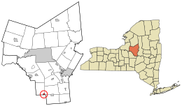
<span class="mw-page-title-main">Oriskany, New York</span> Village in New York, United States

Oriskany is a village in Oneida County, New York, United States. The population was 1,315 at the 2020 census. The name is derived from the Iroquois word for "nettles".

<span class="mw-page-title-main">Sangerfield, New York</span> Town in New York, United States

Sangerfield is a town in Oneida County, New York, United States. The population was 2,561 at the 2010 census. The town is named after Jedediah Sanger, an early settler.

<span class="mw-page-title-main">Whitestown, New York</span> Town in New York, United States

Whitestown is a town in Oneida County, New York, United States. The population was 18,667 at the 2010 census. The name is derived from Judge Hugh White, an early settler. The town is immediately west of Utica and the New York State Thruway passes across the town. The offices of the town of Whitestown are in the Village of Whitesboro.

<span class="mw-page-title-main">Chatfield, Ohio</span> Village in Ohio, United States

Chatfield is a village in Crawford County, Ohio, United States. The population was 205 at the 2020 census.

<span class="mw-page-title-main">Tarlton, Ohio</span> Village in Ohio, United States

Tarlton is a village in Fairfield and Pickaway counties in the U.S. state of Ohio. The population was 254 at the 2020 census.

<span class="mw-page-title-main">Nixon, Pennsylvania</span> Census-designated place in Pennsylvania, United States

Nixon is a census-designated place (CDP) in Penn Township, Butler County, Pennsylvania, United States. The population was 1,373 at the 2010 census.

<span class="mw-page-title-main">Valley Falls, Rhode Island</span> Village and census-designated place in Rhode Island, US

Valley Falls is a village and census-designated place (CDP) in the town of Cumberland, Providence County, Rhode Island, United States. The population was 12,094 at the 2020 census.

<span class="mw-page-title-main">Chester (CDP), Vermont</span> Census-designated place in Vermont, United States

Chester is a census-designated place (CDP) in Windsor County, Vermont, United States. The population was 1,005 at the 2010 census. The CDP is a statistical area encompassing three distinct places: the urbanized center of the town of Chester; a locale known as Chester Depot, which is separated from the town center by the tracks of the former Rutland Railroad; and the village of North Chester.

<span class="mw-page-title-main">Rewey, Wisconsin</span> Village in Wisconsin, United States

Rewey is a village in Iowa County, Wisconsin, United States. The population was 292 at the 2010 census. It is part of the Madison Metropolitan Statistical Area.

<span class="mw-page-title-main">Hamburg (village), New York</span> Village in New York, United States

Hamburg is a village in Erie County, New York, United States. The population was 9,696 at the 2020 census. The village is named after Hamburg, the second largest city in Germany. It is part of the Buffalo-Niagara Falls metropolitan area.

<span class="mw-page-title-main">Madison (village), New York</span> Village in New York, United States

Madison is a village in Madison County, New York, United States. The population was 305 at the 2010 census. The village and its town are named after President James Madison.

<span class="mw-page-title-main">Dallas, Wisconsin</span> Village in Wisconsin, United States

Dallas is a village in Barron County in the U.S. state of Wisconsin. The population was 409 at the 2010 census. The village is located within the Town of Dallas.

References

  1. "ArcGIS REST Services Directory". United States Census Bureau. Retrieved September 20, 2022.
  2. "National Register Information System". National Register of Historic Places . National Park Service. March 13, 2009.
  3. "US Gazetteer files: 2010, 2000, and 1990". United States Census Bureau. February 12, 2011. Retrieved April 23, 2011.
  4. "Census of Population and Housing". Census.gov. Retrieved June 4, 2015.
  5. "U.S. Census website". United States Census Bureau . Retrieved January 31, 2008.