Oneida County is a county in the state of New York, United States. As of the 2020 census, the population was 232,125. The county seat is Utica. The name is in honor of the Oneida, one of the Five Nations of the Iroquois League or Haudenosaunee, which had long occupied this territory at the time of European encounter and colonization. The federally recognized Oneida Indian Nation has had a reservation in the region since the late 18th century, after the American Revolutionary War.

Utica is a city in the Mohawk Valley and the county seat of Oneida County, New York, United States. The tenth-most-populous city in New York State, its population was 65,283 in the 2020 U.S. Census. Located on the Mohawk River at the foot of the Adirondack Mountains, it is approximately 95 mi (153 km) west-northwest of Albany, 55 mi (89 km) east of Syracuse and 240 mi (386 km) northwest of New York City. Utica and the nearby city of Rome anchor the Utica–Rome Metropolitan Statistical Area comprising all of Oneida and Herkimer Counties.

Oneida is a city in Madison County in the U.S. state of New York. It is located west of Oneida Castle and east of Wampsville. The population was 11,390 at the 2010 census. The city, like both Oneida County and the nearby silver and china maker, was named for the Oneida tribe, which had a large territory here around Oneida Lake during the colonial period.

Floyd is a town in Oneida County, New York, United States. The population was 3,819 at the 2010 census. The town is named after William Floyd, a signer of the Declaration of Independence.
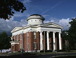
Rome is a city in Oneida County, New York, United States, located in the central part of the state. The population was 32,127 at the 2020 census. Rome is one of two principal cities in the Utica–Rome Metropolitan Statistical Area, which lies in the "Leatherstocking Country" made famous by James Fenimore Cooper's Leatherstocking Tales, set in frontier days before the American Revolutionary War. Rome is in New York's 22nd congressional district.

Waterville is a village in Oneida County, New York, United States. According to the 2010 census, its population was 1,583.

Western is a town in Oneida County, New York, United States. The population was 1,951 at the 2010 census.

Waverly is the largest village in Tioga County, New York, United States. According to the 2010 U.S. Census, Waverly had a population of 4,177. It is located southeast of Elmira in the Southern Tier region. This village was incorporated as the southwest part of the town of Barton in 1854. The village name is attributed to Joseph "Uncle Joe" Hallett, founder of its first Fire Department and pillar of the community, who conceived the name by dropping the second "e" from the name of his favorite author's novel, Waverley by Sir Walter Scott. The former village hall is listed on the National Historic Places list.

Camden is a town in Oneida County, New York, United States. The population was 4,934 at the 2010 census.
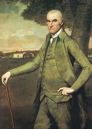
William Floyd was an American Founding Father, wealthy farmer, and political leader from New York. Floyd served as a delegate to the Continental Congress and was a signer of the Continental Association and Declaration of Independence. In August 1776, a few weeks after the Declaration was signed, the British Army overran Long Island, confiscated Floyd's house and estate, and used the property as a base for its cavalry over the next seven years. Floyd remained active in politics throughout the Revolutionary Era, served as a major general in the New York State militia, and was elected to the first U.S. Congress in 1789.

The Mohawk River [TieonontatátieKanien'ké:ha for "a river flowing through a mountain"] is a 149-mile-long (240 km) river in the U.S. state of New York. It is the largest tributary of the Hudson River. The Mohawk flows into the Hudson in Cohoes, New York, a few miles north of the city of Albany. The river is named for the Mohawk Nation of the Iroquois Confederacy. It is a major waterway in north-central New York. The largest tributary, the Schoharie Creek, accounts for over one quarter (26.83%) of the Mohawk River's watershed. Another main tributary is the West Canada Creek, which makes up for 16.33% of the Mohawk's watershed.

The Mohawk Valley region of the U.S. state of New York is the area surrounding the Mohawk River, sandwiched between the Adirondack Mountains and Catskill Mountains, northwest of the Capital District. As of the 2010 United States Census, the region's counties have a combined population of 622,133 people. In addition to the Mohawk River valley, the region contains portions of other major watersheds such as the Susquehanna River.

New York State Railways was a subsidiary of the New York Central Railroad that controlled several large city streetcar and electric interurban systems in upstate New York. It included the city transit lines in Rochester, Syracuse, Utica, Oneida and Rome, plus various interurban lines connecting those cities. New York State Railways also held a 50% interest in the Schenectady Railway Company, but it remained a separate independent operation. The New York Central took control of the Rochester Railway Company, the Rochester and Eastern Rapid Railway and the Rochester and Sodus Bay Railway in 1905, and the Mohawk Valley Company was formed by the railroad to manage these new acquisitions. New York State Railways was formed in 1909 when the properties controlled by the Mohawk Valley Company were merged. In 1912 it added the Rochester and Suburban Railway, the Syracuse Rapid Transit Railway, the Oneida Railway, and the Utica and Mohawk Valley Railway. The New York Central Railroad was interested in acquiring these lines in an effort to control the competition and to gain control of the lucrative electric utility companies that were behind many of these streetcar and interurban railways. Ridership across the system dropped through the 1920s as operating costs continued to rise, coupled with competition from better highways and private automobile use. New York Central sold New York State Railways in 1928 to a consortium led by investor E. L. Phillips, who was looking to gain control of the upstate utilities. Phillips sold his stake to Associated Gas & Electric in 1929, and the new owners allowed the railway bonds to default. New York State Railways entered receivership on December 30, 1929. The company emerged from receivership in 1934, and local operations were sold off to new private operators between 1938 and 1948.

New York State Route 365 (NY 365) is an east–west state highway in the central portion of New York, United States. It extends for 44.26 miles (71.23 km) from an intersection with NY 5, east of the Madison County city of Oneida to a junction with NY 8 in the Herkimer County town of Ohio. The portion of NY 365 in western and central Oneida County is a regionally important highway that serves densely populated areas, including the cities of Oneida and Rome. In Verona, a town situated midway between the two locations, NY 365 passes by the Turning Stone Resort & Casino and connects to the New York State Thruway. East of Barneveld, a village in eastern Oneida County, NY 365 is a rural connector road that runs along the Hinckley Reservoir, a waterbody that extends into Herkimer County and Adirondack Park.

The Oneida Carry was an important link in the main 18th century trade route between the Atlantic seaboard of North America and interior of the continent. From Schenectady, near Albany, New York on the Hudson River, cargo would be carried upstream along the Mohawk River using boats known as bateaux. At the location at modern-day Rome, New York, the cargo and boats would be portaged one to four miles overland to Wood Creek. This portage, which the Haudenosaunee called De-o-Wain-Sta, was known as the Oneida Carry or The Great Carrying Place in English, and as Trow Plat in Dutch. After relaunching into Wood Creek, the bateaux would navigate downstream to Oneida Lake, the Oswego River, and ultimately Lake Ontario at Oswego. Lake Ontario was the gateway to all the Great Lakes stretching another thousand miles inland.

New York State Route 46 (NY 46) is a state highway in Central New York in the United States. It extends from NY 12B in the Madison County town of Eaton to NY 12D in the Oneida County village of Boonville. NY 46 passes through the cities of Oneida and Rome.

New York State Route 274 (NY 274) is a 10.44-mile (16.80 km) state highway located entirely in Oneida County, New York, in the United States. The route begins at an intersection with NY 365 in the village of Holland Patent and heads north and west for 5 miles (8 km) in each direction to a junction with NY 46 at the hamlet of Frenchville in the town of Western. A two-lane highway its entire length, much of NY 274 is narrow and winding. The northwesternmost 2 miles (3.2 km) of the highway are particularly narrow and curved, running alongside a tributary of the Mohawk River. NY 274 was originally designated as part of New York State Route 46A, an alternate route of NY 46 between Rome and Western, in 1930 before gaining its current designation in the early 1950s.
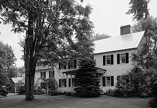
The Gen. William Floyd House is a historic house on Main Street at Gifford Hill Road in Westernville, New York. Built in 1803, it was the last home of Founding Father William Floyd (1734–1821), a signer of the Declaration of Independence, and a driving force in the settlement of the area. It was declared a National Historic Landmark in 1971. The house is a private residence, and is not normally open to the public.

Wood Creek is a river in Central New York State that flows westward from the city of Rome, New York to Oneida Lake. Its waters flow ultimately to Lake Ontario, which is the easternmost of the five Great Lakes. Wood Creek is less than 20 miles (32 km) long, but has great historical importance. Wood Creek was a crucial, fragile link in the main 18th and early 19th century waterway connecting the Atlantic seaboard of North America and its interior beyond the Appalachian Mountains. This waterway ran upstream from the Hudson River along the Mohawk River. Near present day Rome, the Mohawk River is about one mile from Wood Creek across dry land. In the 18th century, cargo and boats were portaged between the Mohawk and Wood Creek; the crossing was called the "Oneida Carry". In 1797, the Rome Canal was completed and finally established an all-water route. The waterway then followed a downstream run along Wood Creek to the east end of Oneida Lake. After a 20 mile crossing to the west end of the lake, the waterway entered the Oswego River system. This system led either to the Lake Ontario port at Oswego, or further westward along the Seneca River.

Western Town Hall, also known as Liberty Hall, is a historic town hall building located at Westernville in Oneida County, New York. It was built in 1911 and is a two-story, gable roofed timber frame structure. It was constructed from dismantled components of the ca. 1850 Empire Hotel in Delta. It was rebuilt as "Liberty Hall," a social gathering hall, and named in honor of General William Floyd. The second floor has an auditorium. It has been used as the town hall since 1962.


