Durhamville, New York

Last updated
Durhamville, New York
USA New York location map.svg
Red pog.svg
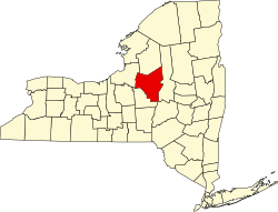
Durhamville, New York
Location within the state of New York
Coordinates: 43°7′14″N75°40′16″W / 43.12056°N 75.67111°W / 43.12056; -75.67111
Country United States
State New York
County Oneida
Elevation
433 ft (132 m)
Time zone UTC-5 (Eastern (EST))
  Summer (DST) UTC-4 (EDT)
ZIP code
13054
Area code 315
FIPS code 36-36065
GNIS feature ID0948834 [1]

Durhamville is a hamlet located in Oneida County, New York, United States. The population was 584 as of the 2010 census.

Contents

The Hamlet of Durhamville is in the southern part of the county and is approximately 1.75 miles north of Oneida on Route 46. It is located within the town of Verona, New York.

History

Durhamville is a small hamlet that was founded before 1813 and named for Eber Durham.

From the mid-1800s until the early 1900s, Durhamville was home to Erie Canal barge construction and repair. In particular, it was home to an Erie Canal lock which was abandoned when the route of the canal was changed. It was also the location of the Fox & Company glass house which, at the time, was one of the largest glass companies in the nation. [2]

Geography

Durhamville is located at 43°7′14″N75°40′16″W / 43.12056°N 75.67111°W / 43.12056; -75.67111 (43.1206241, -75.6710161). [3]

Related Research Articles

<span class="mw-page-title-main">Oneida County, New York</span> County in New York, United States

Oneida County is a county in the state of New York, United States. As of the 2020 census, the population was 232,125. The county seat is Utica. The name is in honor of the Oneida, one of the Five Nations of the Iroquois League or Haudenosaunee, which had long occupied this territory at the time of European encounter and colonization. The federally recognized Oneida Indian Nation has had a reservation in the region since the late 18th century, after the American Revolutionary War.

<span class="mw-page-title-main">Chittenango, New York</span> Village in New York, United States

Chittenango is a village located in Madison County, New York, United States. The village is in the southern part of the Town of Sullivan. The population was 4,896 at the 2020 census. Chittenango is the birthplace of L. Frank Baum, author of The Wonderful Wizard of Oz.

Lenox is a town in Madison County, New York, United States. The population was 9,112 as of the 2010 census.

<span class="mw-page-title-main">Oneida, New York</span> City in Madison County, New York, US

Oneida is a city in Madison County in the U.S. state of New York. It is located west of Oneida Castle and east of Wampsville. The population was 11,390 at the 2010 census. The city, like both Oneida County and the nearby silver and china maker, was named for the Oneida tribe, which had a large territory here around Oneida Lake during the colonial period.

<span class="mw-page-title-main">Forestport, New York</span> Town in New York, United States

Forestport is a town in Oneida County, New York, United States. The population was 1,535 at the 2010 census.

<span class="mw-page-title-main">Marcy, New York</span> Town in New York, United States

Marcy is a town in Oneida County, New York, United States. The population was 8,982 at the 2010 census. The town was named after Governor William L. Marcy. It lies between the cities of Rome and Utica. The Erie Canal passes through the southern part of the town.

<span class="mw-page-title-main">Oriskany, New York</span> Village in New York, United States

Oriskany is a village in Oneida County, New York, United States. The population was 1,400 at the 2010 census. The name is derived from the Iroquois word for "nettles".

<span class="mw-page-title-main">Verona, New York</span> Town in New York, United States

Verona is a town in southwestern Oneida County, New York, United States. The population was 6,293 at the 2010 census. The town was named after Verona, Italy.

<span class="mw-page-title-main">Vienna, New York</span> Town in New York, United States

Vienna is a town in Oneida County, New York, United States. The population was 5,440 at the 2010 census. The town is named after the capital of Austria.

<span class="mw-page-title-main">Gaines, New York</span> Town in New York, United States

Gaines is a town in Orleans County, New York, United States. The population was 3,378 at the 2010 census. The town is named after General Edmund P. Gaines, who defended the area during the War of 1812.

<span class="mw-page-title-main">Boonville (village), New York</span> Village in New York, United States

Boonville is a village in Oneida County, New York, United States. The population was 2,072 at the 2010 census. The village is named after Gerrit Boon, an agent of the Holland Land Company.

<span class="mw-page-title-main">Vernon, New York</span> Town in New York, United States

Vernon is a town in Oneida County, New York, United States. The population was 5,408 at the 2010 census.

<span class="mw-page-title-main">New York State Route 31</span> Highway in New York

New York State Route 31 (NY 31) is a state highway that extends for 208.74 miles (335.93 km) across western and central New York in the United States. The western terminus of the route is at an intersection with NY 104 in the city of Niagara Falls. Its eastern terminus is at a traffic circle with NY 26 in Vernon Center, a hamlet within the town of Vernon. Over its routing, NY 31 spans 10 counties and indirectly connects three major urban areas in Upstate New York: Buffalo–Niagara Falls, Rochester, and Syracuse. The route is one of the longest routes in New York State, paralleling two similarly lengthy routes, NY 104 to the north and NY 5 to the south, as well as the Erie Canal, as it proceeds east.

<span class="mw-page-title-main">New York State Route 365</span> State highway in central New York, US

New York State Route 365 (NY 365) is an east–west state highway in the central portion of New York, United States. It extends for 44.26 miles (71.23 km) from an intersection with NY 5, east of the Madison County city of Oneida to a junction with NY 8 in the Herkimer County town of Ohio. The portion of NY 365 in western and central Oneida County is a regionally important highway that serves densely populated areas, including the cities of Oneida and Rome. In Verona, a town situated midway between the two locations, NY 365 passes by the Turning Stone Resort & Casino and connects to the New York State Thruway. East of Barneveld, a village in eastern Oneida County, NY 365 is a rural connector road that runs along the Hinckley Reservoir, a waterbody that extends into Herkimer County and Adirondack Park.

<span class="mw-page-title-main">Old Erie Canal State Historic Park</span> State park surrounding an old segment of the Erie Canal

The Old Erie Canal State Historic Park encompasses a 36-mile (58 km) linear segment of the original Erie Canal's Long Level section. It extends westward from Butternut Creek in the town of DeWitt, just east of Syracuse, to the outskirts of Rome, New York. The park includes restored segments of the canal's waterway and towpath which were in active use between 1825 and 1917. It is part of the New York State Park system.

<span class="mw-page-title-main">New York State Route 49</span> State highway in central New York, US

New York State Route 49 (NY 49) is an east–west state highway in central New York in the United States. It runs for just over 64 miles (103 km) from an intersection with NY 3 in the town of Volney in Oswego County, New York to an interchange with Interstate 790 (I-790), NY 5, NY 8 and NY 12 in the city of Utica in Oneida County. The route follows a generally northwest–southeast alignment between the two points, passing along the north shore of Oneida Lake and directly serving the city of Rome. As NY 49 heads east, it connects to several highways of regional importance, such as I-81 in the village of Central Square and NY 13 in the town of Vienna. Most of NY 49 is a two-lane surface road; however, the section between Rome and Utica is a freeway known as the Utica–Rome Expressway.

<span class="mw-page-title-main">New York State Route 46</span> State highway in central New York, US

New York State Route 46 (NY 46) is a state highway in Central New York in the United States. It extends from NY 12B in the Madison County town of Eaton to NY 12D in the Oneida County village of Boonville. NY 46 passes through the cities of Oneida and Rome.

<span class="mw-page-title-main">New York State Route 316</span> State highway in Madison County, New York, US

New York State Route 316 (NY 316) is a state highway in Madison County, New York, in the United States. It extends for 4.03 miles (6.49 km) in a northwest–southeast direction from an intersection with NY 46 in the city of Oneida to a junction with NY 31 in the hamlet of Oneida Valley, located in the town of Lenox. NY 316 serves as a connector between Oneida Lake and the city of Oneida, and it parallels Oneida Creek for its entire length. The route was assigned as part of the 1930 renumbering of state highways in New York, following what had previously been part of NY 31 during the 1920s.

Verona Beach is a hamlet in Oneida County, New York, United States. The community is located along the eastern shore of Oneida Lake and New York State Route 13; the Erie Canal separates the community from neighboring Sylvan Beach. Verona Beach has a post office with ZIP code 13162. Verona Beach State Park is located in the community.

References

  1. Geographic Names Information System. US Geological Survey. Retrieved 2011-01-26.
  2. http://www.oneidacountyhistory.org/Spotlight/Verona/Verona.asp Archived 2012-03-29 at the Wayback Machine . Oneida County Historical Society. Retrieved 2011-01-26.
  3. http://www.histopolis.com/Place/US/NY/Oneida_County/Durhamville. Histopolis. Retrieved 2011-01-26.