Marshall, New York

Last updated

Marshall, New York
NY 315 sb entering Forge Hollow (2), July 2023.jpg
Hamlet of Forge Hollow in town of Marshall
Oneida County New York incorporated and unincorporated areas Marshall highlighted.svg
Location in Oneida County and the state of New York.
Coordinates: 42°57′50″N75°23′36″W / 42.96389°N 75.39333°W / 42.96389; -75.39333
CountryUnited States
State New York
County Oneida
Government
  Type Town Council
   Town Supervisor Morris Sturdevant (R)
   Town Council
Members' List
Area
[1]
  Total32.80 sq mi (84.96 km2)
  Land32.80 sq mi (84.96 km2)
  Water0.00 sq mi (0.00 km2)
Elevation
1,158 ft (353 m)
Population
 (2010)
  Total2,131
  Estimate 
(2016) [2]
2,119
  Density64.60/sq mi (24.94/km2)
Time zone UTC-5 (Eastern (EST))
  Summer (DST) UTC-4 (EDT)
FIPS code 36-45755
GNIS feature ID0979201

Marshall is a town in Oneida County, New York, United States. The population was 2,131 at the 2010 census.

Contents

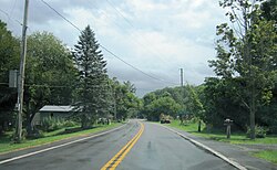
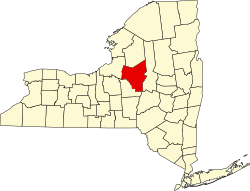
The Town of Marshall is in the southeastern part of the county and is located southwest of Utica.

History

The first settlers were the Brothertown Indians, a group of about 400 people formed from scattered remnants of tribes from New England and Long Island, led by Asa Dick and Samson Occom, who arrived around 1774. They were granted land by the Oneida Indians, for the purpose of creating a new township for Christian Indians. They made their homes around the Oriskany Creek, which provided power for their grist mills. Many Brotherton Indians left town during the Revolutionary War, returning after end of the war to farm. Because Brotherton Indians came from different peoples whose languages were not mutually intelligible, many adopted the English language. The number of Brotherton Indians had dwindled by 1850, with some succumbing to alcoholism, and others selling their land and moving to Green Bay, Wisconsin. [3]

The first white settlers arrived in 1794 and settled in the higher regions, in Hanover and the west hills. The town was formed in 1829 from the Town of Kirkland.

Geography

According to the United States Census Bureau, the town has a total area of 32.8 square miles (85 km2), all land.

Part of the southern town line is the border of Madison County.

Demographics

Historical population
CensusPop.Note
1830 1,908
1840 2,25118.0%
1850 2,115−6.0%
1860 2,1340.9%
1870 2,1450.5%
1880 2,2766.1%
1890 2,145−5.8%
1900 1,804−15.9%
1910 1,744−3.3%
1920 1,490−14.6%
1930 1,431−4.0%
1940 1,5417.7%
1950 1,6164.9%
1960 1,90217.7%
1970 2,0728.9%
1980 2,1312.8%
1990 2,125−0.3%
2000 2,1270.1%
2010 2,1310.2%
2016 (est.)2,119 [2] −0.6%
U.S. Decennial Census [4]

As of the census [5] of 2000, there were 2,127 people, 786 households, and 579 families residing in the town. The population density was 64.8 inhabitants per square mile (25.0/km2). There were 829 housing units at an average density of 25.3 per square mile (9.8/km2). The racial makeup of the town was 98.54% White, 0.52% African American, 0.14% Asian, 0.05% from other races, and 0.75% from two or more races. Hispanic or Latino of any race were 0.80% of the population.

There were 786 households, out of which 36.1% had children under the age of 18 living with them, 60.1% were married couples living together, 8.9% had a female householder with no husband present, and 26.3% were non-families. 21.9% of all households were made up of individuals, and 7.8% had someone living alone who was 65 years of age or older. The average household size was 2.71 and the average family size was 3.16.

In the town, the population was spread out, with 28.0% under the age of 18, 7.9% from 18 to 24, 29.0% from 25 to 44, 24.2% from 45 to 64, and 11.0% who were 65 years of age or older. The median age was 37 years. For every 100 females, there were 99.3 males. For every 100 females age 18 and over, there were 98.2 males.

The median income for a household in the town was $42,125, and the median income for a family was $47,214. Males had a median income of $31,150 versus $24,196 for females. The per capita income for the town was $19,133. About 6.8% of families and 10.1% of the population were below the poverty line, including 13.8% of those under age 18 and 7.0% of those age 65 or over.

Communities and locations in Marshall

Related Research Articles

<span class="mw-page-title-main">Guilford, New York</span> Town in New York, United States

Guilford is a town in Chenango County, New York, United States. The town is on the eastern border of the county. The population was 2,922 at the 2010 census.

<span class="mw-page-title-main">Ohio, New York</span> Town in New York, United States

Ohio is a town in Herkimer County, New York, United States. The population was 1,002 at the 2010 census. The town is named after the state of Ohio. The town is in the northern part of the county and northeast of Utica. Part of Ohio is within the Adirondack Park.

<span class="mw-page-title-main">Schuyler, New York</span> Town in Herkimer County, New York, US

Schuyler is a town in Herkimer County, New York, United States. The population was 3,420 at the 2010 census. The town is in the western part of Herkimer County and is east of Utica.

<span class="mw-page-title-main">Sullivan, New York</span> Town in Madison County, New York, US

<span class="mw-page-title-main">Augusta, New York</span> Town in New York, United States

Augusta is a town in Oneida County, New York, United States. The population was 2,020 at the 2010 census.

<span class="mw-page-title-main">Kirkland, New York</span> Town in Oneida County, New York, United States

Kirkland is a town in Oneida County, New York, United States. The population was 10,315 at the 2010 census. The town is named after Samuel Kirkland, a missionary among the Oneidas.

<span class="mw-page-title-main">Sangerfield, New York</span> Town in New York, United States

Sangerfield is a town in Oneida County, New York, United States. The population was 2,561 at the 2010 census. The town is named after Jedediah Sanger, an early settler.

<span class="mw-page-title-main">Steuben, New York</span> Town in Oneida County, New York, US

Steuben is a town in Oneida County, New York, United States. The population was 1,110 at the 2010 census. The town is named after Baron von Steuben, a Prussian general who fought on the American side in the American Revolutionary War.

<span class="mw-page-title-main">Verona, New York</span> Town in New York, United States

Verona is a town in southwestern Oneida County, New York, United States. The population was 6,293 at the 2010 census. The town was named after Verona, Italy.

<span class="mw-page-title-main">Vienna, New York</span> Town in New York, United States

Vienna is a town in Oneida County, New York, United States. The population was 5,440 at the 2010 census. The town is named after the capital of Austria.

<span class="mw-page-title-main">Waterville, New York</span> Village in New York, United States

Waterville is a village in Oneida County, New York, United States. According to the 2010 census, its population was 1,583.

<span class="mw-page-title-main">Westmoreland, New York</span> Town in New York, United States

Westmoreland is a town in Oneida County, New York, United States. The population was 6,138 at the 2010 census.

<span class="mw-page-title-main">Whitestown, New York</span> Town in New York, United States

Whitestown is a town in Oneida County, New York, United States. The population was 18,667 at the 2010 census. The name is derived from Judge Hugh White, an early settler. The town is immediately west of Utica and the New York State Thruway passes across the town. The offices of the town of Whitestown are in the Village of Whitesboro.

<span class="mw-page-title-main">Hastings, New York</span> Town in New York, United States

Hastings is a town in Oswego County, New York, United States. Its population was 9,450 at the 2010 census. It is named after Hastings Curtiss, a prominent citizen and member of the State Assembly in 1824.

<span class="mw-page-title-main">Herkimer (town), New York</span> Town in New York, United States

Herkimer is a town in Herkimer County, New York, United States, southeast of Utica. It is named after Nicholas Herkimer. The population was 10,175 at the 2010 census.

Hamilton is a town in Madison County, New York, United States. The population was 6,690 at the 2010 census. The town is named after American Founding Father Alexander Hamilton, and is a college town, with Colgate University dominating the town's employment, culture and population.

<span class="mw-page-title-main">Bridgewater, New York</span> Town in New York, United States

Bridgewater is a town in Oneida County, New York, United States. The population was 1,522 at the 2010 census.

<span class="mw-page-title-main">Vernon, New York</span> Town in New York, United States

Vernon is a town in Oneida County, New York, United States. The population was 5,408 at the 2010 census.

<span class="mw-page-title-main">Constantia (town), New York</span> Town in New York, United States

Constantia is a town in Oswego County, New York, United States. The population was 4,973 at the 2010 census.

<span class="mw-page-title-main">Hannibal, New York</span> Town in New York, United States

Hannibal is a town in Oswego County, New York, United States. The population was 4,854 at the 2010 census. The name is derived from the hero of ancient Carthage, Hannibal.

References

  1. "2016 U.S. Gazetteer Files". United States Census Bureau. Retrieved July 5, 2017.
  2. 1 2 "Population and Housing Unit Estimates" . Retrieved June 9, 2017.
  3. Child, Hamilton (1869). Gazetteer and business directory of Oneida County. Syracuse, NY: Printed at the Journal office. pp.  98–99.
  4. "Census of Population and Housing". Census.gov. Retrieved June 4, 2015.
  5. "U.S. Census website". United States Census Bureau . Retrieved January 31, 2008.