Oneida County is a county in the state of New York, United States. As of February 26, 2024, the population was 226,654. The county seat is Utica. The name is in honor of the Oneida, one of the Five Nations of the Iroquois League or Haudenosaunee, which had long occupied this territory at the time of European encounter and colonization. The federally recognized Oneida Indian Nation has had a reservation in the region since the late 18th century, after the American Revolutionary War. The county is part of the Mohawk Valley region of the state.

Farmingdale is an incorporated village on Long Island within the Town of Oyster Bay in Nassau County, New York, United States. The population was 8,466 at the time of the 2020 Census.

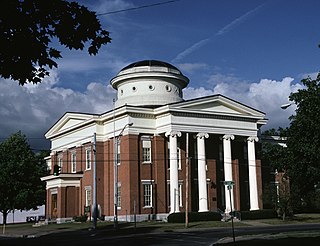
Marshall is a town in Oneida County, New York, United States. The population was 1,966 at the 2020 census.

Red Hook is a village in Dutchess County, New York, United States. The population was 1,975 at the 2020 census. It is part of the Poughkeepsie–Newburgh–Middletown, NY Metropolitan Statistical Area as well as the larger New York–Newark–Bridgeport, NY-NJ-CT-PA Combined Statistical Area. The name is derived from the Dutch "Roode Hoeck" – hoeck meaning peninsula, and roode meaning red – a reference to the vibrant reds in the area's fall foliage.

Patricia Jane Berg was an American professional golfer. She was a founding member and the first president of the LPGA. Her 15 major title wins remains the all-time record for most major wins by a female golfer. She is a member of the World Golf Hall of Fame.
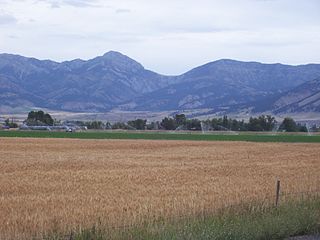
The Bridger Range, also known as the Bridger Mountains, is a subrange of the Rocky Mountains in southwestern Montana in the United States. The range runs mostly in a north–south direction between Bozeman and Maudlow. It is separated from the Gallatin Range to the south by Bozeman Pass; from the Horseshoe Hills to the west by Dry Creek; from the Crazy Mountains to the east by the Shields River valley; and from the Big Belt Mountains to the north by Sixteen Mile Creek. The highest point in the Bridger Range is Sacagawea Peak, which is visible to the northeast from Bozeman.

Herrontown Woods Arboretum is an arboretum located on Snowden Lane near the junction with Herrontown Road, in Princeton, New Jersey. It is open to the public every day at no cost. There are walking trails, but trail bicycles are prohibited.
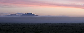
The Wet Mountains are a small mountain range in southern Colorado, named for the amount of snow they receive in the winter as compared to the dry Great Plains to the east. They are a sub-range of the Sangre de Cristo Mountains, in the southern Rocky Mountains System. There are three variant names of mountain range: Cuerno Verde, Greenhorn Mountains, and Sierra Mojada.
Hardscrabble was a small unincorporated community in Green Township, Madison County, Indiana. As of 1989 it had four houses, and its population was never greater than 16.
Hardscrabble or Hard Scrabble is land that is rocky or of poor quality, as in the term hardscrabble farm. It is often used as a euphemism for any sort of hard working or poverty, as in hardscrabble childhood. A number of towns use this name:
New York has 2,192 MW of installed wind power capacity as of 2022. Most of New York's wind power is located in upstate New York as onshore wind farms. New York has set a goal of developing 9,000 MW of offshore installed wind power capacity by 2035 that will power an estimated 6 million homes. As of October 2022, New York has five offshore wind farms in development with approximately 4,300 MW installed capacity.
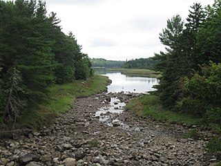
Hardscrabble River is the estuary of Wilson Stream, a small river in Washington County, Maine. From its source in Charlotte, Wilson Stream runs about 10 miles (16 km) southeast to Dennys Bay. It changes name to Hardscrabble River at about the point where it is crossed by U.S. Route 1. This section of the stream separates Pembroke on its left bank from Dennysville and Edmunds on its right.

Hardscrabble is an unincorporated community in Highland County, Virginia, United States. Hardscabble is located 10.3 miles (16.6 km) north of Monterey, Virginia near the border with West Virginia. The community is situated along the Straight Fork in the Alleghany Valley.
Hardscrabble Farm is a historic farm property in rural Searsmont, Maine, United States. Located south of its village center at 122 Maine State Route 131, the 70-acre (28 ha) property features a typical New England connected farmstead with a c. 1840s Greek Revival farmhouse. The property is notable as the leisure time summer residence of author Ben Ames Williams, who fictionalized Searsmont as the town of "Fraternity" in his works. The property was listed on the National Register of Historic Places in 1994.

Rum Hill is a mountain located in Central New York Region of New York northwest of the Hamlet of Pierstown. Red House Hill is located southeast, Metcalf Hill is located south, Allen Lake and Mohegan Hill are located north-northwest and Otsego Lake is located east of Rum Hill.
Fitch Hill is a mountain located in Central New York Region of New York by Pierstown. Fitch Hill is named after the Fitch family who were early settlers in the area.
Kilkenny Hill is a mountain in the Central New York region of New York, United States. It is located northwest of Unadilla, New York. Kilkenny Hill is part of the Northern Allegheny Plateau Ecoregion.

Hardscrabble Mountain is a summit located in Custer County, Colorado with an elevation of 3,171 metres (10,404 ft). It is one of the peaks in Wet Mountains, a sub-range of the Sangre de Cristo Range of the Rocky Mountains. A local legend is that the mountain was named after an event from Christmas Day 1855. Ute Native Americans attacked settlers in Pueblo, after which soldiers pursued the Utes. They ran up the creek and had a “hard scrabble” to avoid being captured.

Franklin Corners is an unincorporated community located along the Passaic River at the intersection of County Route 613 and U.S. Route 202 in Bernards Township of Somerset County, New Jersey. In the 19th century, it had a grist mill, saw mill, general store, school, and several houses. The Franklin Corners Historic District, featuring Van Dorn's Mill, was listed on the National Register of Historic Places in 1975.
The Frontier Pathways is a 103-mile (166 km) National Scenic Byway and Colorado Scenic and Historic Byway located in Custer and Pueblo counties, Colorado, US.

