
Sand Lake is a town in south-central part of Rensselaer County, New York, United States. Sand Lake is about 13 miles east of Albany, New York. As of the 2020 census, the population was 8,348. Within the town are four hamlets: West Sand Lake, Averill Park, Glass Lake and the hamlet of Sand Lake. Its four lakes are a source of recreation. Many commercial enterprises of the 19th century and into the 20th century relied on power generated from the Wynants Kill Creek and Burden Lake mills. The area is known for its fertile soil for grazing and agriculture.

Oneonta is a town in Otsego County, New York, United States. The population was 5,065 at the 2020 census.,

Otsego Lake is a 4,046-acre (16.37 km2) lake located in Otsego County in the U.S. state of New York. It is the source of the Susquehanna River and largest lake in Otsego County. The Village of Cooperstown is located at the lake's southern end. Glimmerglass State Park is located on the lake's northeastern shore, and includes Hyde Hall, a large mansion constructed in 1817, that overlooks the lake. The Glimmerglass Opera, opened in June 1987, is located on the western shore.

Canadarago Lake is a 1,917-acre (7.76 km2) lake located in Otsego County, New York and is the source of Oaks Creek. The Village of Richfield Springs is located at the lake's northern end. It is the second largest lake in Otsego County, lying to the west of and parallel to the larger Otsego Lake. The lake's name is also spelled "Candajarago Lake" or "Caniadaraga Lake".
Indian Creek is a 31.0-mile-long (49.9 km) tributary of the Youghiogheny River in Fayette County, Pennsylvania in the United States.
Abrams Creek is an 11.2-mile-long (18.0 km) tributary stream of Opequon Creek in Frederick County and the independent city of Winchester in Virginia. Abrams Creek rises north of Round Hill and flows in a southeasterly direction through Winchester. From Winchester, Abrams Creek flows east into Opequon Creek. The stream was originally known as Abraham's Creek.
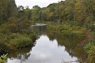
Oaks Creek is a river that drains Canadarago Lake, which is situated in the north central region of Otsego County, New York. The creek begins by the Hamlet of Schuyler Lake and flows southeast approximately 9.32 miles (15.00 km), dropping only 105 feet (32 m) in elevation, before converging with the Susquehanna River south of the Village of Cooperstown, by the Hamlet of Index. From the source to Oaksville the creek flows along Panther Mountain. Fly Creek is a main tributary, that converges with Oaks Creek south of the Hamlet of Fly Creek.

Leatherstocking Creek is a small creek in central Otsego County, New York. It begins northwest of Pierstown and flows southeast then south before flowing into Otsego Lake north of Cooperstown, and just south of Three Mile Point.
Panther Mountain is a mountain located in Central New York of New York near Fly Creek, New York and Schuyler Lake, New York. The east side of Panther Mountain drains into Fly Creek and the west side drains into Oaks Creek and Canadarago Lake.

Rum Hill is a mountain located in Central New York Region of New York northwest of the Hamlet of Pierstown. Red House Hill is located southeast, Metcalf Hill is located south, Allen Lake and Mohegan Hill are located north-northwest and Otsego Lake is located east of Rum Hill.

Mount Wellington is a mountain located in the Central New York Region of New York. It is located south of the Hamlet of Springfield Center at the northern end of Otsego Lake. Mount Wellington rises 600 feet (180 m) above lake level. The extreme southern point of the mountain is called Clarke Point and also referred to as the Shad Cam. It is known as "The Sleeping Lion", as it looks similar to a lion laying down, viewed from Cooperstown, New York. It was originally named Mount Millington, but was renamed by George Hyde Clarke in honor of Field Marshal The 1st Duke of Wellington, the victor of Waterloo, who had been Clarke's schoolmate at Eton College in England.
Red House Hill is a mountain in the Central New York Region of the State of New York, United States. It is located south-southwest of the Hamlet of Springfield Center, New York, west of Hutter Point and Six Mile Point of Otsego Lake, and southeast of Rum Hill. Mohican Brook flows eastward along the southern edge of the hill.
Fitch Hill is a mountain located in Central New York Region of New York by Pierstown. Fitch Hill is named after the Fitch family who were early settlers in the area.
Metcalf Hill is a mountain in the central New York region of New York by Pierstown. Metcalf Hill is named after Arunah Metcalf.
Cornish Hill is a small mountain chain, made of two main elevations the tallest being 2,231 feet (680 m). Cornish Hill is located in the Central New York region of New York southeast Cooperstown, New York.
Klock Hill is a mountain located in Central New York region of New York southwest of Burlington, New York.
Kilkenny Hill is a mountain in the Central New York region of New York, United States. It is located northwest of Unadilla, New York. Kilkenny Hill is part of the Northern Allegheny Plateau Ecoregion.
Mount Zion is a small mountain chain in the Central New York region of New York. It is located southwest of Otego, New York. It is made of two main peaks. One is in Otsego County and the other, being the tallest at 1988 feet, in Delaware County.
Calder Hill is a small mountain chain in the Central New York region of New York. It is located north of Otego, New York. It is made of two main peaks with the highest being 1841 feet.
Whitethorn Creek is a 15.01 mi (24.16 km) long 4th order tributary to the Banister River in Pittsylvania County, Virginia. The Whitehorn Creek watershed and its tributary, Mill Creek, are the location of one of the largest uranium deposits in the United States on Cole Hill.

