Brace Mountain is the peak of a ridge in the southern Taconic Mountains, near the tripoint of the U.S. states of New York, Connecticut and Massachusetts. Its 2,311-foot (704 m) main summit is located in New York; it is the highest point in that state's Dutchess County. [1] [2]
The New York and Massachusetts portions of the mountain are within protected areas; Taconic State Park and Mount Washington State Forest respectively. The Connecticut portions are privately owned and conserved.
It is a challenging yet popular hike since its summit, along with 2,304-foot (702 m) subpeak South Brace Mountain, are along the 15.7 mi (25.3 km) South Taconic Trail. Hikers approach the mountain either from the New York side on the west via the South Taconic or from another trail following the Connecticut-Massachusetts state line on the east, a route that allows them to visit both the tristate marker and the highest point in Connecticut, near the summit of Mount Frissell, along the way. Brace's bald summit, marked by a large cairn, offers views in all directions, particularly to the Hudson Valley and Catskills to the west. It has become a popular site for launching hang gliders and paragliders.
Brace is near the south end of an escarpment roughly paralleling the Connecticut and Massachusetts state lines, which runs north–south east of the summit, in North East, New York, at the northeast corner of a narrow northward extension of Dutchess County. To its east is the largely undeveloped, privately owned Riga Plateau, with Riga Lake, Connecticut's highest at 1,749 ft (533 m), to the south in the town of Salisbury, Connecticut. Due east, on the other escarpment, is 2,316-foot (706 m) Bear Mountain, Connecticut's highest summit. There is a 100-foot (30 m) drop into the col between Brace and South Brace, a quarter-mile (250 m) to the south. The ridge continues to the south for several miles past the lower Mount Riga and Thorpe Mountain before ending where U.S. Route 44 crosses the state line. [3]
One mile (1.6 km) to the northeast is the nearest other summit, 2,453-foot (748 m) Mount Frissell, located just over Connecticut's northern border in Mount Washington, Massachusetts. A short distance from the summit, the state line reaches 2,370 feet (720 m), the highest elevation in Connecticut. To its east is 2,296-foot (700 m) Round Mountain, in Connecticut. [3]
Approximately 0.3 miles (0.48 km) north-northeast of Brace's summit is the tripoint where New York, Connecticut and Massachusetts meet. The ridge continues north-northwest to 2,250-foot (690 m) Alander Mountain, in the western corner of Massachusetts, where the highest point in New York's Columbia County is located at the state line below the summit. Beyond that it continues to Catamount Ski Area, straddling the state line. [3]
The west slope of the ridge drops steeply 1,300 feet (400 m) to the narrow floor of the north end of the Harlem Valley, also known as the Oblong, the region of Dutchess County within a short distance of the state line, claimed by both New York and Connecticut during the colonial era. Here there are some farms and houses, with New York State Route 22 and the Harlem Valley Rail Trail running through. Across the valley, in the town of Ancram, rises 1,346-foot (410 m) Fox Hill. [4]
Four miles (6.4 km) to the south is the village of Millerton, New York, the nearest large settlement. The small hamlet of Copake, New York, is three miles (4.8 km) to the north-northwest. In Connecticut, Lakeville is to the southwest of the Riga Plateau area. [3]
The west side of Brace Mountain drains into the Noster Kill, then into Bash Bish Brook, the Roeliff Jansen Kill, thence the Hudson River and the Atlantic Ocean. The southwest side drains into Webatuck Creek, Ten Mile River, thence the Housatonic River and Long Island Sound. The southeast side drains into Riga Lake and South Pond, then into Wachocostinook Brook, Salmon Creek, and the Housatonic River. The north side drains into Ashley Hill Brook, thence Bash Bish Brook, and the Roeliff Jansen Kill. [3] [4]
The white-blazed South Taconic Trail traverses the summit. It provides for both access from the west, via its southern terminus, and the east via the connecting Mt. Frissell trail along the Connecticut-Massachusetts state line. An old, unmarked dirt road also connects to the South Taconic north of the summit from more directly east of the mountain. Other access routes that once approached from the Riga Lake area at the southeast have been closed in Connecticut by the landowner, their blazes removed in New York. [5]
Approaching via the South Taconic from the west, entirely within New York, is a common route to the summit but also entails the greatest vertical ascent. The trailhead for the South Taconic is located on Quarry Hill Road, a long dead-end street in the northern section of North East, at an elevation just under 1,000 feet (300 m). After passing along the edge of an old meadow, it enters the woods, crosses into Taconic State Park and then climbs steeply past a series of cascades on the south side, at some points requiring that hikers scramble. It levels off at 1,700 feet (520 m), where the first of many views over Dutchess and Columbia counties to the Catskill Escarpment on the other side of the Hudson River open up. At that point it turns north and goes through some private lands over South Brace to Brace. The total distance from the trailhead is 1.9 miles (3.1 km) with a 1,300-foot (400 m) vertical gain. [6]
On the west the Mount Frissell Trail starts following red blazes at a trailhead on the state line, on an unpaved road known as East Street in Mount Washington and Mt. Washington Road in Salisbury. From an elevation of 1,830 feet (560 m) It first bends into Massachusetts, then returns to Connecticut where it climbs to the open summit of Round Mountain, where Frissell and Brace can be seen ahead. Descending into the woods, it re-enters Massachusetts and makes a short but steep climb to the summit of Frissell. A register for visitors to the Connecticut high point hangs from a tree; the highpoint itself is marked by a small survey stake a short distance further along the trail, after it descends slightly and follows the state line. From the highpoint it drops gently to pass the tri-state marker. Its western terminus, 2.2 miles (3.5 km) from the trailhead, is on the South Taconic approximately 0.3 miles (480 m) north of Brace's summit. It is thus 2.5 miles (4.0 km) via this approach, with a vertical gain of roughly 1,000 ft (300 m) due to the ascents of Round and Frissell required by the route. [7]
The approach via the unofficial Brace Mountain Trail is the gentlest and shortest, but less used due to the limited parking and minimal maintenance of the trail, entirely on private land in Connecticut. The unblazed, gated road starts from a small parking area on Mount Washington Road two miles (3.2 km) north of the dam at South Pond in Lakeville, just south of where the road, the highest in Connecticut, crosses the shoulder of Gridley Mountain. From this 1,900-foot (580 m) elevation it descends slightly to cross an unnamed tributary of Monument Brook, after which an overgrown ascends gently to the state line marker, 1.3 miles (2.1 km) from the parking area. From there it is a more sustained climb 0.2 miles (320 m) to the South Taconic and an equivalent distance to the summit. The total distance for this approach is 1.7 miles (2.7 km) with a 460-foot (140 m) vertical gain from the brook crossing. [8]
There are also two long approaches from the north. On the New York side, the red-blazed Robert Brook Trail leaves the blue-blazed Alander Brook Trail 450 feet (140 m) from that trail's head along Under Mountain Road in Ancram. From there it climbs 1,050 feet (320 m) in 1.1 miles (1.8 km) to the South Taconic Trail just west of the state line, 2.6 miles (4.2 km) north of Brace's summit. [7] In Massachusetts, the blue-blazed Ashley Hill Trail leaves the Alander Mountain Trail west of the Mount Washington State Forest headquarters at the junction of East and West streets. Two possible forks allow for a 4-mile (6.4 km) route to Brace via the Mount Frissell Trail. [5]
The summit of Brace is an open area with scrubby forest on the slopes. A cairn several feet high, with a small windsock attached, sits on the highest ground. There are views available in all directions.
To the west are the highest mountains visible from Brace, the Catskills. The dominant visible feature is the long Escarpment to the north, with 4,040-foot (1,230 m) Hunter Mountain, the highest point of Greene County, high above the peaks of the Devil's Path beyond it. Further south are the peaks of Ulster County, including Slide, the highest in that county and the Catskills at 4,180 feet (1,270 m). [6]
Northwest the Helderberg Escarpment is visible, south of Albany. Closer to the mountain, the lower hills of Columbia and Dutchess counties are below. In the latter, Stissing Mountain and its fire tower, south of Pine Plains stand out. The Hudson Highlands are in the distant southwest. [6]
To the east the landscape falls away into the Riga Plateau, with Gridley and Bear rising across it. Riga Lake can be seen to the south of them. The higher peaks of the vicinity, Frissell and Round, are visible on the northeast, although the former blocks the view of Mount Everett, the 2,602-foot-high (793 m) peak of the south Taconics. Next to Frissell, in the distance on clear days, Mount Greylock, Massachusetts' 3,491-foot (1,064 m) highest peak, can be seen. Due north is Alander. [6]
The Mount Brace Outdoor Club, based in the valley below the mountain, operates the landing zone for hang gliding and paragliding from the summit. All such foot-launched aircraft pilots must sign in at the club, whether or not they are members. [9] This is done under permit with the state Office of Parks, Recreation and Historic Preservation; pilots who do not check in with the club can be cited and fined. [10]
Pilots must obey some other rules as well. They must be current United States Hang Gliding and Paragliding Association (USHPA) members with a rating of at least P3/H2 to fly without instructor supervision; P2/H2-rated pilots must have a minimum of 10 mountain flights from more than a thousand feet (300 m) above ground level, witnessed by an instructor, in their logbooks in order to fly unsupervised, since the launch area at the summit is steep and narrow. No flights are permitted on days with winds of more than 26 miles per hour (42 km/h). [10]
The windsock on the summit cairn was placed to allow the pilots to judge conditions. They hike in either from the east via the old road or up the South Taconic from its southern trailhead. There are some other lower launch areas lower on the mountain, on private land. It is one of the more popular locations for hang gliding and paragliding in the Northeast due to the gradual geography of the area and the thermals allowing smooth flight down the 1,600 feet (490 m) to the LZ at the club facilities. [11]
Mount Washington is a town in Berkshire County, Massachusetts, United States. It is part of the Pittsfield, Massachusetts Metropolitan Statistical Area. It lies at the very southwestern corner of Massachusetts, bordering New York State and Salisbury, Connecticut.
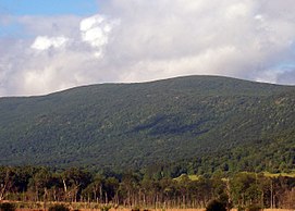
Bear Mountain is a peak of the southern Taconic Mountains in Salisbury, Connecticut. At 2,316 feet (706 m), Bear Mountain is the highest mountain that lies wholly within Connecticut. However, it is not the state highpoint: in the 1940s, the United States Geological Survey determined that the highest elevation in the state, at 2,380 feet (725 m), was actually on the nearby Connecticut-Massachusetts border, on the southern slope of Massachusetts’ Mount Frissell. There is a stone monument on the Bear Mountain summit. The Appalachian Trail crosses the mountain in a generally north-south direction.
The Taconic Mountains are a 150-mile-long sub-range of the Appalachian Mountains lying on the eastern border of New York State and adjacent New England. The range, which played a role in the history of geological science, is separated from the Berkshires and Green Mountains to the east by a series of valleys, principally those of the Housatonic River, Battenkill River and Otter Creek. The Taconics' highest point is Mount Equinox in Vermont at 3,840 feet (1,170 m); among many other summits are Dorset Mountain, Mount Greylock and Mount Everett.
Hunter Mountain is in the towns of Hunter and Lexington, just south of the village of Hunter, in Greene County, New York, United States. At approximately 4,040 feet (1,231 m) in elevation, it is the highest peak in the county and the second-highest peak in the Catskill Mountains.
Mount Frissell, 2,454 feet (748 m), which straddles the border of southwest Massachusetts and northwest Connecticut, is part of the Taconic Range. Frissell's south slopes include the highest point in Connecticut, a popular destination for highpointers.
Slide Mountain is the highest peak in the Catskill Mountains of the U.S. state of New York. It is located in the town of Shandaken in Ulster County. While the 4,180-foot (1,270 m) contour line on topographic maps is generally accepted as its height, the exact elevation of the summit has never been officially determined by the U.S. National Geodetic Survey or its predecessors, and many informal surveys suggest the mountain may actually top 4,200 feet (1,280 m) above sea level. Geographically, it is the highest natural point within the New York Metropolitan Area.
Mount Washington State Forest is a 4,619-acre (1,869 ha) state forest in Mount Washington, Massachusetts. The forest conjoins with New York state and the state of Connecticut in the southern Taconic Mountains of the southwestern Berkshire region of Massachusetts. In addition to offering recreational and scenic opportunities, the forest lies adjacent to Bash Bish Falls State Park. It is managed by the Massachusetts Department of Conservation and Recreation.
Taconic State Park is located in Columbia and Dutchess County, New York abutting Massachusetts and Connecticut within the Taconic Mountains. The state park is located off New York State Route 344 south of Interstate 90 and 110 miles (180 km) north of New York City. It features camping, hiking, bicycling, hunting, cross county skiing and other recreational opportunities.
Kaaterskill High Peak is one of the Catskill Mountains, located in the Town of Hunter in Greene County, New York, United States. It was once believed to be the highest peak in the entire range, but its summit, at 3,655 feet (1,114 m) in elevation, places it only 23rd among the Catskill High Peaks. It is, however, the fourth most prominent peak in the range. Due to its situation as the easternmost High Peak, its summit is just outside the watersheds of New York City's reservoirs in the region.
The Appalachian National Scenic Trail spans 14 U.S. states over its roughly 2,200 miles (3,500 km): Georgia, North Carolina, Tennessee, Virginia, West Virginia, Maryland, Pennsylvania, New Jersey, New York, Connecticut, Massachusetts, Vermont, New Hampshire, and Maine. The southern end is at Springer Mountain, Georgia, and it follows the ridgeline of the Appalachian Mountains, crossing many of its highest peaks and running almost continuously through wilderness before reaching the northern end at Mount Katahdin, Maine.
Panther Mountain is one of the Catskill High Peaks, located in the Town of Shandaken in Ulster County, New York. At approximately 3,720 feet (1,130 m) in elevation, it is the 18th highest in the range. A combination of factors has led some geologists to believe the mountain is on the site of an ancient meteorite impact crater.
Gridley Mountain, 2,211 feet (674 m), is the third highest elevation in the state of Connecticut. The mountain, part of the Taconic Range, has no official trail and is located on private property. The Mount Washington Road passes the mountain from the west.
Balsam Lake Mountain is one of the Catskill Mountains, located in the Town of Hardenburgh, New York, United States. It is the westernmost of the range's 35 High Peaks. Its exact height has not been determined, but the highest contour line on topographic maps, 3,720 feet (1,130 m), is usually given as its elevation.
The South Taconic Trail is a 21.3 mi (34.3 km) hiking trail in the Taconic Mountains of southwest Massachusetts and adjacent New York. The trail extends from Shagroy Road in Millerton, New York, north along the ridgecrest of the southern Taconic Range and the border of New York and Massachusetts, and ends north of the Catamount Ski Area on Massachusetts Route 23 700 feet (210 m) east of the New York border in Egremont, Massachusetts. The Appalachian Trail, which traverses an adjacent ridgeline in the same mountain range, parallels the South Taconic Trail 3 mi (4.8 km) to the east. The trails are connected to one another via shorter trails.
The Taconic Crest Trail is a 37 mi (60 km) hiking trail in the Taconic Mountains in the northeastern United States. The trail extends from U.S. Route 20 in Hancock, Massachusetts, less than 1 mi (1.6 km) east of the New York border, north along the ridgecrest of the Taconic Range, first within Massachusetts, then weaving along the border of New York and Massachusetts and New York and Vermont, and ending in Petersburgh, New York, on NY Route 346, near the Vermont border. Much of the route has been conserved as state forest, conservation easement, or forest preserve.
Berlin Mountain is a 2,818-foot-tall (859 m) prominent peak in the Taconic Mountains of western New England and is located adjacent to Massachusetts's border with New York State. It is the highest point in Rensselaer County. The summit and west side of the mountain are located in New York; the east side lies within Williamstown, Massachusetts. The mountain is a bald, notable for its grassy summit and expansive views of the Hudson River Valley to the west. The 37-mile (60 km) Taconic Crest Trail traverses the mountain. Several other hiking trails approach the summit from the east. Much of the upper slopes and summit are within protected conservation land. Historically the lower slopes of the mountain were farmed heavily throughout the 19th Century. In addition to agriculture, there are several remnants of charcoal kilns located on the mountain that produced fuel for iron smelting.
Alander Mountain is a 2,241-foot-tall (683 m) part of the south Taconic Mountains in southwest Massachusetts and adjacent to New York. The summit is grassy and covered with scrub oak and shrubs; the sides of the mountain are heavily forested. Several trails traverse Alander Mountain, most notably is the 15.7 mi (25.3 km) South Taconic Trail, which passes just beneath the summit.
Round Mountain, 2,296 feet (700 m), located on the border of southwest Massachusetts and northwest Connecticut, is a prominent peak of the Taconic Range. The peak and southern slopes of the mountain are within Connecticut; the northern slope lies within Massachusetts.
Mount Tremper, officially known as Tremper Mountain and originally called Timothyberg, is one of the Catskill Mountains in the U.S. state of New York. It is located near the hamlet of Phoenicia, in the valley of Esopus Creek.