
Pine Plains is a town in Dutchess County, New York, United States. The population was 2,218 at the 2020 census.
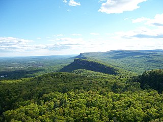
The Shawangunk Ridge, also known as the Shawangunk Mountains or The Gunks, is a ridge of bedrock in Ulster County, Sullivan County and Orange County in the state of New York, extending from the northernmost point of the border with New Jersey to the Catskills. The Shawangunk Ridge is a continuation of the long, easternmost section of the Appalachian Mountains; the ridge is known as Kittatinny Mountain in New Jersey, and as Blue Mountain as it continues through Pennsylvania. This ridge constitutes the western border of the Great Appalachian Valley.

The Taconic Mountains are a 150-mile-long sub-range of the Appalachian Mountains lying on the eastern border of New York State and adjacent New England. The range, which played a role in the history of geological science, is separated from the Berkshires and Green Mountains to the east by a series of valleys, principally those of the Housatonic River, Battenkill River and Otter Creek. The Taconics' highest point is Mount Equinox in Vermont at 3,840 feet (1,170 m); among many other summits are Dorset Mountain, Mount Greylock and Mount Everett.

An allochthon, or an allochthonous block, is a large block of rock which has been moved from its original site of formation, usually by low angle thrust faulting. The term is derived from Greek: allo, meaning other, and chthon, meaning earth. For other possible mechanisms see obduction.

The Taconic orogeny was a mountain building period that ended 440 million years ago (Ma) and affected most of modern-day New England. A great mountain chain formed from eastern Canada down through what is now the Piedmont of the east coast of the United States. As the mountain chain eroded in the Silurian and Devonian periods, sediment spread throughout the present-day Appalachians and midcontinental North America.

The Verdugo Mountains, also known as the Verdugo Hills or simply The Verdugos, are a small, rugged mountain range of the Transverse Ranges system in Los Angeles County, California. Located just south of the western San Gabriel Mountains, the Verdugo Mountains region incorporates the cities of Burbank, Glendale, Pasadena, and La Cañada Flintridge; the unincorporated communities of Altadena and La Crescenta-Montrose; as well as the City of Los Angeles neighborhood of Sunland-Tujunga.
The Lewis Overthrust is a geologic thrust fault structure of the Rocky Mountains found within the bordering national parks of Glacier in Montana, United States and Waterton Lakes in Alberta, Canada. The structure was created due to the collision of tectonic plates about 59-75 million years ago that drove a several mile thick wedge of Precambrian rock 50 mi (80 km) eastwards, causing it to overlie softer Cretaceous age rock that is 1300 to 1400 million years younger.

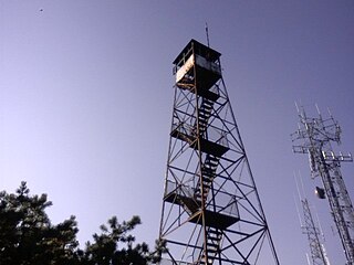
Beacon Mountain, locally Mount Beacon, is the highest peak of Hudson Highlands, located south of City of Beacon, New York, in the Town of Fishkill. Its two summits rise above the Hudson River behind the city and can easily be seen from Newburgh across the river and many other places in the region. The more accessible northern peak, at 1,516 feet (462 m) above sea level, has a complex of radio antennas on its summit; the 1,595 feet (486 m) southern summit has a fire lookout tower, which was built in 1931.

The U.S. state of Georgia is commonly divided into four geologic regions that influence the location of the state's four traditional physiographic regions. The four geologic regions include the Appalachian foreland, Blue Ridge, Piedmont, and Coastal Plain. These four geologic regions commonly share names with and typically overlap the four physiographic regions of the state: the Appalachian Plateau and adjacent Valley and Ridge; the Blue Ridge; the Piedmont and the Coastal Plain.
Clove Mountain is located in Union Vale, Dutchess County, New York, rising to an elevation of 1,398 ft (426 m). It is the town's highest point. It marks the southern extent of the Taconic Mountains and its bedrock is metamorphic, composed of rocks like schist, phyllite, and metagraywacke. Flora and fauna on the mountain are consistent with those found throughout the broader New England Uplands. Rattlesnakes are commonly found on the mountain.

The Geology of Pennsylvania consists of six distinct physiographic provinces, three of which are subdivided into different sections. Each province has its own economic advantages and geologic hazards and plays an important role in shaping everyday life in the state. From the southeast corner to the northwest corner of the state, they include: the Atlantic Plain Province, the Piedmont Province, the New England Province, the Ridge and Valley Province, the Appalachain Province, and the Central Lowlands Province.

Mount Everett is the highest peak in the south Taconic Mountains, rising about 2,000 feet above its eastern footings in Sheffield, Mass. Its summit area is notable for expansive vistas and an unusual dwarf forest of pitch pine and oak. The Appalachian Trail traverses Mount Everett, which prior to the 20th century was called "Dome of the Taconics." Reaching 2,602 feet above sea level, Everett dominates much local scenery of the Housatonic Valley.

The South Taconic Trail is a 21.3 mi (34.3 km) hiking trail in the Taconic Mountains of southwest Massachusetts and adjacent New York. The trail extends from Shagroy Road in Millerton, New York, north along the ridgecrest of the southern Taconic Range and the border of New York and Massachusetts, and ends north of the Catamount Ski Area on Massachusetts Route 23 700 feet (210 m) east of the New York border in Egremont, Massachusetts. The Appalachian Trail, which traverses an adjacent ridgeline in the same mountain range, parallels the South Taconic Trail 3 mi (4.8 km) to the east. The trails are connected to one another via shorter trails.

Berlin Mountain is a 2,818-foot-tall (859 m) prominent peak in the Taconic Mountains of western New England and is located adjacent to Massachusetts's border with New York State. It is the highest point in Rensselaer County. The summit and west side of the mountain are located in New York; the east side lies within Williamstown, Massachusetts. The mountain is a bald, notable for its grassy summit and expansive views of the Hudson River Valley to the west. The 37-mile (60 km) Taconic Crest Trail traverses the mountain. Several other hiking trails approach the summit from the east. Much of the upper slopes and summit are within protected conservation land. Historically the lower slopes of the mountain were farmed heavily throughout the 19th Century. In addition to agriculture, there are several remnants of charcoal kilns located on the mountain that produced fuel for iron smelting.

Brace Mountain is the peak of a ridge in the southern Taconic Mountains, near the tripoint of the U.S. states of New York, Connecticut and Massachusetts. Its 2,311-foot (704 m) main summit is located in New York; it is the highest point in that state's Dutchess County.
Alander Mountain is a 2,241-foot-tall (683 m) part of the south Taconic Mountains in southwest Massachusetts and adjacent to New York. The summit is grassy and covered with scrub oak and shrubs; the sides of the mountain are heavily forested. Several trails traverse Alander Mountain, most notably is the 15.7 mi (25.3 km) South Taconic Trail, which passes just beneath the summit.
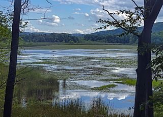
Thompson Pond in Pine Plains, New York is a 75-acre (30 ha) 15,000-year-old glacial kettle pond at the foot of 1,403-foot (428 m) Stissing Mountain. It is the source of Wappinger Creek, a tributary of the Hudson River that drains much of Dutchess County.

The geology of Massachusetts includes numerous units of volcanic, intrusive igneous, metamorphic and sedimentary rocks formed within the last 1.2 billion years. The oldest formations are gneiss rocks in the Berkshires, which were metamorphosed from older rocks during the Proterozoic Grenville orogeny as the proto-North American continent Laurentia collided against proto-South America. Throughout the Paleozoic, overlapping the rapid diversification of multi-cellular life, a series of six island arcs collided with the Laurentian continental margin. Also termed continental terranes, these sections of continental rock typically formed offshore or onshore of the proto-African continent Gondwana and in many cases had experienced volcanic events and faulting before joining the Laurentian continent. These sequential collisions metamorphosed new rocks from sediments, created uplands and faults and resulted in widespread volcanic activity. Simultaneously, the collisions raised the Appalachian Mountains to the height of the current day Himalayas.
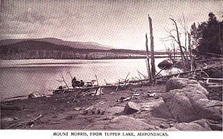
Mount Morris is a 3,117-foot-tall (950 m) mountain located in Adirondack Mountains of New York. It is located in the south-southwest of the village of Tupper Lake in Franklin County, and is "the highest peak immediately east of Tupper Lake." It is named after the town in which it was then located.

The geology of the State of New York is made up of ancient Precambrian crystalline basement rock, forming the Adirondack Mountains and the bedrock of much of the state. These rocks experienced numerous deformations during mountain building events and much of the region was flooded by shallow seas depositing thick sequences of sedimentary rock during the Paleozoic. Fewer rocks have deposited since the Mesozoic as several kilometers of rock have eroded into the continental shelf and Atlantic coastal plain, although volcanic and sedimentary rocks in the Newark Basin are a prominent fossil-bearing feature near New York City from the Mesozoic rifting of the supercontinent Pangea.

