
Ashland County is a county located in the northeastern portion of the U.S. state of Ohio. As of the 2020 census, the population was 52,447. Its county seat and largest city is Ashland. The county is named for "Ashland", the home of Senator Henry Clay near Lexington, Kentucky. It was formed in 1846 from parts of Huron, Lorain, Richland and Wayne Counties.

Ashland is a home rule-class city in Boyd County, Kentucky, United States. The most populous city in Boyd County, Ashland is located upon a southern bank of the Ohio River at the state border with Ohio and near West Virginia. The population was 21,625 at the 2020 census. Ashland is a principal city of the Huntington–Ashland metropolitan area, referred to locally as the "Tri-State area", home to 376,155 residents as of 2020. Ashland serves as an important economic and medical center for northeastern Kentucky.
Ashland is a borough in Schuylkill County in the U.S. state of Pennsylvania, 15 miles (24 km) northwest of Pottsville. It is part of Northeastern Pennsylvania. A small part of the borough also lies in Columbia County, although all of the population resided in the Schuylkill County portion as of the 2020 census. The borough lies in the anthracite coal region of eastern Pennsylvania. Settled in 1850, Ashland was incorporated in 1857, and was named for Henry Clay's estate near Lexington, Kentucky. The population in 1900 was 6,438, and in 1940, 7,045, but had dropped to 2,471 at the 2020 census.
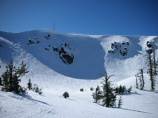
Mount Ashland ski area is located on 7,532-foot (2,296 m) Mount Ashland and features 44 trails on 200 acres (0.81 km2) served by four lifts, including expert terrain in a glacial cirque called The Bowl. The mountain averages 235" of snow annually, with a season from early December until mid-April. 7% of terrain is rated Beginner, 41% is Intermediate, 41% is Advanced, and 11% is Expert.

Custer National Forest is located primarily in the south central part of the U.S. state of Montana but also has separate sections in northwestern South Dakota. With a total area of 1,188,130 acres (4,808 km2), the forest comprises over 10 separate sections. While in the westernmost sections, Custer National Forest is a part of the Greater Yellowstone Ecosystem, the easternmost sections are a combination of forest "islands" and grasslands. A portion of the forest is also part of the Absaroka-Beartooth Wilderness and constitutes over a third of the wilderness land. South of Red Lodge, Montana, the Beartooth Highway passes through the forest en route to Yellowstone National Park.

Located in Lower Merion Township, Montgomery County, Pennsylvania, United States, Belmont Hills is a suburb of Philadelphia. Belmont Hills is a neighborhood within the village of Bala Cynwyd. It is a distinct community with its own public elementary school, public pool, fire department and public library. Belmont Hills is known for its hilly terrain. Belmont means "Beautiful Mountain" so its literal name is "Beautiful Mountain Hills".

Pinnacle Peak is a granite summit located in Scottsdale, Arizona. The peak rises to an elevation of 3,169 feet (966 m). It is located within the 150-acre (61 ha) Pinnacle Peak Park, operated by the City of Scottsdale Park District. Part of the Sonoran Desert, the park is home to a variety of native desert flora and fauna. Hikers utilize a 1.75 mile trail to explore the area, though rock climbing skills are needed to reach the summit.
The Rogue River–Siskiyou National Forest is a United States National Forest in the U.S. states of Oregon and California. The formerly separate Rogue River and Siskiyou National Forests were administratively combined in 2004. Now, the Rogue River–Siskiyou National Forest ranges from the crest of the Cascade Range west into the Siskiyou Mountains, covering almost 1.8 million acres (7,300 km2). Forest headquarters are located in Medford, Oregon.

The Great Craggy Mountains, commonly called the Craggies, are a mountain range in western North Carolina, United States. They are a subrange of the Blue Ridge Mountains and encompass an area of approx. 194 sq mi (503 km²). They are situated in Buncombe County, North Carolina, 14 miles northeast of Asheville. The Black Mountains lie to the northeast, across the upper Cane River valley.

Boyd County is a county located in the U.S. Commonwealth of Kentucky. As of the 2020 census, its population was 48,261. The county seat is Catlettsburg, and its largest city is Ashland. The county was formed in 1860. The county spans 160 square miles (410 km2), and is found at the northeastern edge of the state, near the Ohio River and Big Sandy River and situated in mountainous Appalachia. Boyd County is in the Huntington-Ashland, WV-KY-OH metropolitan statistical area.
Blake Peak is a mountain located in Essex County, New York. The mountain is named after Mills Blake, Verplanck Colvin’s chief assistant during the Adirondack Survey. It is part of the Colvin Range. Blake Peak is flanked to the northeast by Mount Colvin, and to the southwest by Pinnacle.
Higby Mountain or Mount Higby 892 feet (272 m), is a traprock mountain ridge located 3.75 miles (6.04 km) east of Meriden, Connecticut. It is part of the narrow, linear Metacomet Ridge that extends from Long Island Sound near New Haven, Connecticut, north through the Connecticut River Valley of Massachusetts to the Vermont border. Higby Mountain is known for its high cliff faces, unique microclimate ecosystems, and rare plant communities. It rises steeply 600 feet (180 m) above the Quinnipiac River valley and the city of Meriden to the west as a continuous 2-mile (3 km) long ledge. The mountain is traversed by the 50-mile (80 km) Mattabesett Trail.

Mount Ashland is the highest peak in the Siskiyou Mountains of southern Oregon. It was named for the city of Ashland, located 8.6 miles (14 km) north of the mountain. The Siskiyou Mountains are a subrange of the Klamath Mountains in northwestern California and southwestern Oregon. The mountain is part of the Rogue River–Siskiyou National Forest, which encompasses most of the Siskiyou Mountains. The Oregon–California border is 5 miles (8 km) south of the mountain.
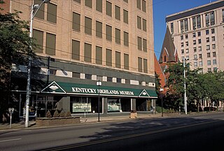
The Highlands Museum and Discovery Center is a heritage center and science center located in Ashland, Kentucky, United States. The museum displays exhibits on local history and specialized science displays for children along with providing educational outreach programs.

Gothic Mountain is a prominent mountain summit in the Elk Mountains range of the Rocky Mountains of North America. The 12,631-foot (3,850 m) peak is located in Gunnison National Forest, 1.1 miles (1.8 km) west by south of the ghost town of Gothic in Gunnison County, Colorado, United States. Gothic Mountain takes its name from its pinnacles said to resemble Gothic architecture.

Huntersfield Mountain is a mountain located in the Catskill Mountains of New York north-northwest of Ashland. Ashland Pinnacle is located east, and Tower Mountain is located south-southeast of Huntersfield Mountain. It is the highest point in Schoharie County and it is ranked 9 of 62 on the list of New York County High Points.
Richmond Mountain is a mountain located in the Catskill Mountains of New York east-northeast of Hunter. Richtmyer Peak is located northeast, Bump Mountain is located south, Steenburg Mountain is located north, and Ashland Pinnacle is located west-southwest of Richmond Mountain.
Bump Mountain is a mountain located in the Catskill Mountains of New York northeast of Ashland. Richtmyer Peak is located north-northeast, The Knob is located west, and Ashland Pinnacle is located west-southwest of Bump Mountain.
The Knob is a mountain in Greene County, New York. It is located in the Catskill Mountains north-northeast of Ashland. Ashland Pinnacle is located north, and Huntersfield Mountain is located northwest of The Knob. The mountain has an elevation of 2,638 feet.
South Mountain is a mountain in Greene County, New York and partially in Schoharie County, New York. It is located in the Catskill Mountains southwest of West Durham. Ashland Pinnacle is located west-southwest, and Steenburg Mountain is located north of South Mountain.

