
Hunter Mountain is in the towns of Hunter and Lexington, just south of the village of Hunter, in Greene County, New York, United States. At approximately 4,040 feet (1,231 m) in elevation, it is the highest peak in the county and the second-highest peak in the Catskill Mountains.

Beacon Mountain, locally Mount Beacon, is the highest peak of Hudson Highlands, located south of City of Beacon, New York, in the Town of Fishkill. Its two summits rise above the Hudson River behind the city and can easily be seen from Newburgh across the river and many other places in the region. The more accessible northern peak, at 1,516 feet (462 m) above sea level, has a complex of radio antennas on its summit; the 1,595 feet (486 m) southern summit has a fire lookout tower, which was built in 1931.
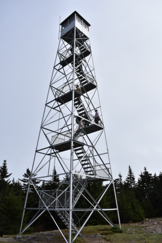
The Hunter Mountain Fire Tower is located on the summit of the eponymous mountain, second highest of the Catskill Mountains in the U.S. state of New York. It was the first of 23 fire lookout towers built by the state in the region, and the next-to-last of the five still standing to be abandoned.

Lyon Mountain is a 3,820 ft (1,160 m) mountain located in Clinton County, New York, the county’s high point. It is named for Nathaniel Lyon, an early settler of the area who moved from Vermont in 1803 and died circa 1850. The mountain is within New York's Adirondack Park.
Gore Mountain is a mountain located near the village of North Creek in Warren County, New York, of which its peak is the highest point. Gore is flanked to the north by South Mountain, and to the southwest by Height of Land Mountain. The mountain is the site of the popular Gore Mountain ski resort. The mountain is the site of the Gore Mountain Fire Observation Station which was built in 1918.

Balsam Lake Mountain is one of the Catskill Mountains, located in the Town of Hardenburgh, New York, United States. It is the westernmost of the range's 35 High Peaks. Its exact height has not been determined, but the highest contour line on topographic maps, 3,720 feet (1,130 m), is usually given as its elevation.

The Red Hill Fire Observation Station consists of a fire lookout tower, cabin and pit privy located on the summit of Red Hill, a 2,990-foot (910 m) Catskill Mountain peak in Denning, New York, United States. It is the southernmost fire tower in the Catskill Park.

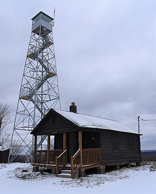
The Balsam Lake Mountain Fire Observation Station is located at the summit of the mountain of that name in the Town of Hardenburgh, New York, United States. It comprises a steel frame fire lookout tower, the observer's cabin and privy and the jeep road to the complex.

Vanderwhacker Mountain is a 3,389-foot-tall (1,033 m) mountain in the Adirondack Mountains region of New York. It is located northeast of Indian Lake and southeast of Newcomb in Essex County. The Vanderwhacker Mountain Fire Observation Station is located on top of the mountain. In May 1911, the Conservation Commission built a wooden fire observation tower on the mountain which was replaced in 1918, with a 35-foot-tall (11 m) metal tower. The tower stopped fire watching operations at the end of the 1988 season.
McCarty Hill is a mountain in the Southern Tier of New York. It is located in Cattaraugus County, mostly in Little Valley and Great Valley, with portions in Ellicottville and Mansfield. In 1940, an 82-foot-6-inch-tall (25.15 m) steel fire lookout tower was built on the mountain. The tower ceased fire lookout operations and then officially closed in early 1989. In 1993, the tower was dismantled and removed and replaced with a free-standing communications tower.
Meenahga Mountain is a 2,087-foot-tall (636 m) mountain located in Adirondack Mountains of New York. It is located in the northeast of the hamlet of Paul Smiths in Franklin County. The mountain is the site of a 73-foot-tall (22 m) Aermotor LS40 fire lookout tower.
Sproul Hill is a mountain in the Finger Lakes region of New York. It is located in west of Watkins Glen in Schuyler County. The mountain is the location of a 67-foot-6-inch-tall (20.57 m) steel fire lookout tower known as the Sugar Hill Fire Tower which was built in 1941. The tower ceased fire lookout operations at the end of 1988, and remains on the mountain and is open to the public.
Jersey Hill is a 2,251-foot-long (686 m) mountain in the Southern Tier of New York. It is located Wells northeast of the hamlet of Allegany County. In 1935, a 79-foot-6-inch-long (24.23 m) steel fire lookout tower was built on the mountain. The Jersey Hill tower was only staffed on an as-needed basis by the Division of Lands and Forests. Due to increased use of aerial fire detection, the tower ceased fire lookout operations and was removed in August 1987.
Bramley Mountain is a mountain located in the Catskill Mountains of New York east-northeast of Delhi. Bovina Mountain is located northeast of Bramley Mountain. The mountain is the former location of fire observation tower, which was removed in 1975. The family that purchased and removed it from the mountain has kept the tower in storage since. In January 2020, Friends of Bramley Mountain group was formed. The family plans to give the tower to the group so it can be placed back at its original location.

Utsayantha Mountain is a 3,209-foot-tall (978 m) mountain in the Catskill Mountains of New York. It is located east-southeast of Stamford in Delaware County. Variant names include Utsayanthe Mountain, Utsayanthia Mountain, Utsayantho Mountain, and Utsyantha Mountain. McGregor Mountain is located southeast of Utsayantha Mountain and Churchill Mountain is located southwest. Utsayantha Mountain is named after Utsayantha, the daughter of Chief Ubiwacha, chief of the Lenape Indians.
Twadell Mountain is a 2,293-foot-tall (699 m) mountain in the Catskill Mountains of New York. It is located north-northeast of East Branch in Delaware County. Rock Rift Mountain is located north-northwest, and Baxter Mountain is located east of Twadell Mountain. In May 1910, a 45-foot-tall (14 m) modified windmill tower was built on the mountain for fire lookout purposes. In 1919, the windmill tower was replaced with a 47-foot-tall (14 m) steel lookout tower. The tower ceased fire lookout operations at the end of the 1972 fire lookout season. The tower still remains but is closed to the public.
Gallis Hill is a 794-foot-tall (242 m) mountain in the Catskill Mountains region of New York. It is located northwest of Kingston in Ulster County. Jockey Hill is located north-northeast, and Morgan Hill is located west of Gallis Hill. In 1927, the Conservation Department built a steel fire lookout tower on the mountain. In 1950, the tower was closed and disassembled then moved to Overlook Mountain, where it still remains today.
Petersburg Mountain is a mountain located in the Catskill Mountains of New York southeast of Cobleskill. Warnerville Hill is located northwest, and Donats Mountain is located northwest of Petersburg Mountain. In 1940, a 67-foot-6-inch-tall (20.57 m) steel fire lookout tower was built on the mountain. The tower was closed at the end of the 1971 season, and later transferred to Schoharie County for use as a radio tower. The tower site is closed to the public.

Rock Rift Fire Observation Tower, also known as the Rock Rift Fire Tower, is a historic fire observation station located in the Town of Tompkins, Delaware County, New York. The tower stands at the summit of Tower Mountain at an elevation of 2,376 ft (724 m) and rises above the Cannonsville Reservoir, part of New York City’s extensive water supply system. It was built in 1934 and listed on the National Register of Historic Places # 100003231 in 2018. The Rock Rift Fire Tower is also listed on the National Historic Lookout Register of the Forest Fire Lookout Association. Its listing numbers are US 1183, NY 41. The tower was transferred to the Town of Tompkins from New York State Department of Environmental Conservation in 2017. The land that the tower rests on is owned by New York City as part of their West of Hudson Watershed. The tower was decommissioned from active use in 1989.
Berry Hill is a 1,962-foot-tall (598 m) mountain in the Central New York region of New York. It is located west-northwest of Norwich in Chenango County. The Berry Hill Fire Observation Station is located on top of the mountain. The fire tower was built by the Civilian Conservation Corps in 1934. The tower ceased operation in 1988 and was officially closed early in 1989. In 1993, the tower was placed on the National Historic Lookout Register. The tower was refurbished and opened to the public on September 13, 2021.


