Jay Mountain (New York)

Last updated
Jay Mountain
Jay Mountain, NY.jpg
Highest point
Elevation 3,600 ft (1,100 m)
Prominence 2,149 ft (655 m)
Coordinates 44°19′11″N73°41′28″W / 44.31972°N 73.69111°W / 44.31972; -73.69111 Coordinates: 44°19′11″N73°41′28″W / 44.31972°N 73.69111°W / 44.31972; -73.69111 [1]
Geography
Location Jay, New York, U.S.
Parent range Adirondacks
Topo map USGS Au Sable Fork
Climbing
Easiest route Hike

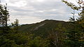
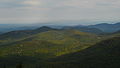
Jay Mountain is the 79th highest peak of the Adirondack Mountains. It is located in Essex County, New York, in the Jay Mountain Wilderness Area, within the towns of Jay and Lewis. [2]

Contents

See also

Related Research Articles

Adirondack Park part of forest preserve in northeastern USA

The Adirondack Park is a part of New York's Forest Preserve in northeastern New York, United States. The park was established in 1892 for “the free use of all the people for their health and pleasure”, for watershed protection, and as a future timber supply. The park's boundary roughly corresponds with the Adirondack Mountains. Unlike most state parks, about 52 percent of the land is privately owned inholdings. State lands within the park are known as Forest Preserve. Land use on public and private lands in the park are regulated by the Adirondack Park Agency. This area contains 102 towns and villages, as well as numerous farms, businesses, and an active timber-harvesting industry. The year-round population is 132,000, with 200,000 seasonal residents. The inclusion of human communities makes the park one of the great experiments in conservation in the industrialized world. The Forest Preserve was designated a National Historic Landmark in 1963.

Catskill Park

The Catskill Park is in the Catskill Mountains in New York in the United States. It consists of 700,000 acres of land inside a Blue Line in four counties: Delaware, Greene, Sullivan, and Ulster. As of 2005, 287,500 acres (116,300 ha) or 41 percent of the land within, is owned by the state as part of the Forest Preserve; it is managed by the Department of Environmental Conservation (DEC). Another 5% is owned by New York City to protect four of the city's reservoirs in the region that lie partially within the park and their respective watersheds.

Mount Marcy Mountain in New York State, USA

Mount Marcy is the highest point in New York, with an elevation of 5,344 feet (1,629 m). It is located in the Town of Keene in Essex County. The mountain is in the heart of the Adirondack High Peaks region of the High Peaks Wilderness Area. Its stature and expansive views make it a popular destination for hikers, who crowd its summit in the summer months.

Catskill High Peaks

The Catskill High Peaks are all of the mountains in New York's Catskill Mountains above 3,500 ft (1,067 m) in elevation whose summits are separated either by one-half mile (0.8 km) or a vertical drop of at least 250 ft (76.2 m) between it and the next nearest separate summit. By usual standards, these mountains are rather low and rounded, and mostly covered by vegetation.

Slide Mountain (Ulster County, New York) Highest peak of New Yorks Catskill Mountains

Slide Mountain is the highest peak in the Catskill Mountains of the U.S. state of New York. It is located in the town of Shandaken in Ulster County. While the 4,180-foot (1,270 m) contour line on topographic maps is generally accepted as its height, the exact elevation of the summit has never been officially determined by the U.S. Coast and Geodetic Survey, and many informal surveys suggest the mountain may actually top 4,200 feet above sea level.

West Canada Creek

The West Canada Creek is a 76-mile-long (122 km) river in upstate New York, United States. West Canada Creek is an important water way in Hamilton, Oneida, and Herkimer counties, draining the south part of the Adirondack Mountains before emptying into the Mohawk River near the Village of Herkimer. The name "Canada" is derived from an Iroquoian word for "village" (Kanata).

Dix Mountain Wilderness Area

The Dix Mountain Wilderness Area is the name previously given to an area of New York's Forest Preserve in the Adirondack Park, and is located in the towns of Elizabethtown, Keene and North Hudson, Essex County. It is roughly bounded on the north by NY 73, on the east by the Adirondack Northway (Interstate 87), on the south by Blue Ridge Road and on the west by Elk Lake Club and Ausable Club lands.

The Northville–Lake Placid Trail, also known as the NPT, is a lightly travelled foot trail that runs 138 miles (214 km) through the Adirondack Park in northern New York State. It was laid out by the Adirondack Mountain Club in 1922 and 1923 and is maintained by the New York State Department of Environmental Conservation. From 2014-2016 the southern section of the trail was re-routed to remove most of the road walk into the town of Northville. The southern terminus is Waterfront Park in Northville, NY and the northern terminus is Averyville Rd in Lake Placid.

Phelps Mountain (New York)

Phelps Mountain is a mountain located in Essex County, New York. The mountain is named after Orson Schofield "Old Mountain" Phelps (1817–1905), who cut the first trail up Mount Marcy and named several of the Adirondack peaks. It is the 32nd highest peak in New York. Phelps Mountain is flanked to the southeast by Table Top Mountain.

Hadley Mountain

Hadley Mountain is a mountain located in the southern Adirondacks in the U.S. state of New York and is the second highest peak in Saratoga County after neighboring Tenant Mountain. The Hadley Mountain Fire Observation Station was listed on the National Register of Historic Places on September 23, 2001 for its role as a Fire lookout tower with the New York State Forest Preserve. Hadley Mountain is the highest of the three peaks that form the West Mountain ridge.

Halcott Mountain

Halcott Mountain is one of the Catskill Mountains of the U.S. state of New York. It is mostly located in Greene County, with some of its lower slopes in Delaware and Ulster counties. Its exact summit elevation has not been officially determined, but the highest contour line on the mountain is 3,520 feet (1,070 m). It is one of the peaks on the divide between the Delaware and Hudson watersheds.

Balsam Mountain (Ulster County, New York) Mountain in New York, USA

Balsam Mountain is one of the High Peaks of the Catskill Mountains in the U.S. state of New York. Its exact height has not been determined, so the highest contour line, 3,600 feet (1,100 m), is usually given as its elevation. It is located in western Ulster County, on the divide between the Hudson and Delaware watersheds. The summit and western slopes of the peak are within the Town of Hardenburgh and its eastern slopes are in Shandaken. The small community of Oliverea is near its base on that side. Most of the mountain is publicly owned, managed by the New York State Department of Environmental Conservation as part of the state Forest Preserve, part of the Big Indian-Beaverkill Range Wilderness Area in the Catskill Park. The summit is on a small corner of private land.

Balsam Lake Mountain Westernmost of the Catskill High Peaks in U.S. state of New York

Balsam Lake Mountain is one of the Catskill Mountains, located in the Town of Hardenburgh, New York, United States. It is the westernmost of the range's 35 High Peaks. Its exact height has not been determined, but the highest contour line on topographic maps, 3,720 feet (1,130 m), is usually given as its elevation.

Moose River Plains Wild Forest

The Moose River Plains Wild Forest is a 64,322-acre tract in the Adirondack Park in Hamilton and Herkimer counties in the state of New York in the United States of America; it is designated as Wild Forest by the New York State Department of Environmental Conservation.

Ampersand Mountain

Ampersand Mountain is a 3,352 ft (1,021.7 m) mountain in Franklin County in the High Peaks Wilderness Area of the northeastern Adirondacks, west of the High Peaks proper in New York State. The trail up the mountain begins on New York State Route 3 8.1 miles (13.0 km) southwest of the village of Saranac Lake, near Middle Saranac Lake; it is a popular day hike. The mountain takes its name from nearby Ampersand Creek, so named because it twists and turns like the ampersand symbol. The summit is bare rock, with extensive views of the High Peaks to the east and the Saranac Lakes to the west. Stony Creek Mountain is located west-southwest of Ampersand Mountain. The mountain is notable as the land surrounding its hiking trail's initial ascent is generally acknowledged as unlogged old growth forest.

Lake Colden

Lake Colden is a 41-acre (17 ha) lake located in the Adirondack High Peaks in New York, United States. Lake Colden sits at 2764 feet at the western base of 4,714-foot Mount Colden. To the northwest lie the MacIntyre Mountains— 5,115-foot Algonquin Peak, 4829-foot Boundary Peak, 4,843-foot Iroquois Peak and 4,380-foot Mount Marshall. Mount Marcy is 2.8 miles (4.5 km) to the east. Lake Colden is fed by Avalanche Lake, to the northeast and in turn feeds Flowed Lands, to the southwest.

Balsam Lake Mountain Fire Observation Station United States historic place

The Balsam Lake Mountain Fire Observation Station is located at the summit of the mountain of that name in the Town of Hardenburgh, New York, United States. It comprises a steel frame fire lookout tower, the observer's cabin and privy and the jeep road to the complex.

Poke-O-Moonshine Mountain

Poke-O-Moonshine Mountain, spelled Pokamoonshine on U.S. Geological Survey maps, and sometimes known as just Poke-O, is a minor peak of the Adirondack Mountains. The name is believed to be a corruption of the Algonquin words pohqui, meaning 'broken', and moosie, meaning 'smooth'. It is located in the town of Chesterfield, New York, United States, on New York state Forest Preserve land, part of the Taylor Pond Wild Forest complex within the Adirondack Park. Due to its location next to the pass through which most travelers from the north enter the range, it has been called the "gateway to the Adirondacks".

North Creek (conservation area)

North Creek is a wildland in the George Washington and Jefferson National Forests of western Virginia that has been recognized by the Wilderness Society as a special place worthy of protection from logging and road construction. Tall evergreen and hardwood trees in the area around Apple Orchard Falls tower above ferns and wildflowers. The area includes a valley which extends from Sunset Fields in the east to its western border near the North Creek Camping Area.

References

  1. United States Department of the Interior. "The USGS Store". USGS. USA.gov. Archived from the original on 1 June 2013. Retrieved 11 September 2013.
  2. New York State Department of Environmental Conservation. "Jay Mountain Wilderness Area - Unit Management Plan". Department of Environmental Conservation. Department of Environmental Conservation. Retrieved 8 September 2013.