Interstate 87 (I-87) is a 333.49-mile-long (536.70 km) north–south intrastate Interstate Highway located within the U.S. state of New York, and is most of the main highway between New York City and Montreal. The highway begins at exit 47 off I-278 in the New York City borough of the Bronx, just north of the Triborough Bridge and Grand Central Parkway. From there, the route runs northward through the Hudson Valley, the Capital District, and the easternmost part of the North Country to the Canadian border in the Town of Champlain. At its north end, I-87 continues into Quebec as Autoroute 15 (A-15). I-87 connects with several regionally important roads: I-95 in New York City, New York State Route 17 near Harriman, I-84 near Newburgh, and I-90 in Albany. The route is the longest intrastate Interstate Highway in the Interstate Highway System. The highway is not contiguous with I-87 in North Carolina.

The Catskill Mountains, also known as the Catskills, are a physiographic province of the larger Appalachian Mountains, located in southeastern New York. As a cultural and geographic region, the Catskills are generally defined as those areas close to or within the borders of the Catskill Park, a 700,000-acre (2,800 km2) forest preserve forever protected from many forms of development under New York state law.

The Finger Lakes Trail consists of a network of trails in New York. The trail system is administered by the Finger Lakes Trail Conference (FLTC), a non-profit organization, composed primarily of volunteers.

Sterling Forest State Park is a 21,938-acre (88.78 km2) state park located in the Ramapo Mountains in Orange County, New York. Established in 1998, it is among the larger additions to the New York state park system in the last 50 years.

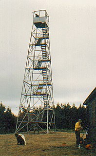
Beacon Mountain, locally Mount Beacon, is the highest peak of Hudson Highlands, located south of City of Beacon, New York, in the Town of Fishkill. Its two summits rise above the Hudson River behind the city and can easily be seen from Newburgh across the river and many other places in the region. The more accessible northern peak, at 1,531 feet above sea level, has a complex of radio antennas on its summit; the 1,610-foot southern summit has a fire lookout tower, which was built in 1931.
New York State Route 28N (NY 28N) is an east–west state highway in the North Country of New York in the United States. It extends for 50.95 miles (82.00 km) through the Adirondack Mountains from Blue Mountain Lake to North Creek. The route is a northerly alternate route to NY 28 between both locations; as such, it passes through several communities that NY 28 bypasses to the south. The westernmost 10 miles (16 km) of NY 28N overlap with NY 30 through the town of Long Lake. NY 28N and NY 30 split in the hamlet of Long Lake, from where NY 30 heads to the north and NY 28N proceeds eastward through mountainous regions of Adirondack Park.
The Hunter Mountain Fire Tower is located on the summit of the eponymous mountain, second highest of the Catskill Mountains in the U.S. state of New York. It was the first of 23 fire lookout towers built by the state in the region, and the next-to-last of the five still standing to be abandoned.

Black Mountain is a mountain located in Washington County, New York, of which its peak is the highest point. Isolated from the rest of the Adirondack Mountains by Lake George, Black Mtn. has the seventh highest topographic prominence of all the mountains in New York. Black Mountain also has the highest elevation of any of the peaks which surround Lake George and offers unobstructed views of the lake from its summit.
Gore Mountain is a mountain located near the village of North Creek in Warren County, New York, of which its peak is the highest point. Gore is flanked to the north by South Mountain, and to the southwest by Height of Land Mountain. The mountain is the site of the popular Gore Mountain ski resort. The mountain is the site of the Gore Mountain Fire Observation Station which was built in 1918.

Hadley Mountain is a mountain located in the southern Adirondacks in the U.S. state of New York and is the second highest peak in Saratoga County after neighboring Tenant Mountain. The Hadley Mountain Fire Observation Station was listed on the National Register of Historic Places on September 23, 2001 for its role as a Fire lookout tower with the New York State Forest Preserve. Hadley Mountain is the highest of the three peaks that form the West Mountain ridge.
Mount Tremper, officially known as Tremper Mountain and originally called Timothyberg, is one of the Catskill Mountains in the U.S. state of New York. It is located near the hamlet of Phoenicia, in the valley of Esopus Creek.

The Balsam Lake Mountain Fire Observation Station is located at the summit of the mountain of that name in the Town of Hardenburgh, New York, United States. It comprises a steel frame fire lookout tower, the observer's cabin and privy and the jeep road to the complex.

Gomer Hill is a 2,106-foot-tall (642 m) mountain in the Tug Hill region of New York. It is located west-northwest of Turin in Lewis County. In 1940, a 67-foot-6-inch-tall (20.57 m) steel fire lookout tower was built on the mountain. The tower ceased fire lookout operations at the end of the 1988 season, and officially closed the next year. The tower site is open to the public, but the tower is closed and used as an antenna support structure.
Stillwater Mountain is a 2,244-foot-tall (684 m) mountain in Adirondack Mountains of New York. It is located south of Stillwater in the town of Webb in Herkimer County. In 1919, a 47-foot-tall (14 m) steel fire lookout tower was built on the mountain. At the end of the 1988 fire lookout season, the tower ceased fire lookout operation. The tower was restored and is open to the public except from the second Tuesday in October through December 20th.
Woodhull Mountain is a 2,359-foot-tall (719 m) mountain in the Adirondack Mountains of New York. It is located east-southeast of Minnehaha in the Town of Webb in Herkimer County. In 1916, a 50-foot-tall (15 m) steel fire lookout tower was built on the mountain. The tower ceased fire lookout operations at the end of the 1970 season. The tower still remains and is open to the public with the exception of the tower cab.
Rock Rift Fire Observation Tower, also known as the Rock Rift Fire Tower, is a historic fire observation station located in the Town of Tompkins, Delaware County, New York. The tower stands at the summit of Tower Mountain at an elevation of 2,376 ft (724 m) and rises above the Cannonsville Reservoir, part of New York City’s extensive water supply system. It was built in 1934 and listed on the National Register of Historic Places # 100003231 in 2018. The Rock Rift Fire Tower is also listed on the National Historic Lookout Register of the Forest Fire Lookout Association. Its listing numbers are US 1183, NY 41. The tower was transferred to the Town of Tompkins from New York State Department of Environmental Conservation in 2017. The land that the tower rests on is owned by New York City as part of their West of Hudson Watershed. The tower was decommissioned from active use in 1989.

Goodnow Mountain is a 2,664-foot-tall (812 m) peak in the Adirondack Mountains of New York in the United States. It is the location of the Goodnow Mountain Fire Observation Station. In 1922, the Civilian Conservation Corps built a 60-foot-tall fire tower on the mountain. The tower closed at the end of the 1979 season. The tower was later transferred to SUNY College of Forestry and is now open to the public.

Berry Hill is a mountain in the Central New York region of New York. It is located west-northwest of Norwich in Chenango County. The Berry Hill Fire Observation Station is located on top of the mountain. The fire tower was built by the Civilian Conservation Corps in 1934. The tower ceased operation in 1988 and was officially closed early in 1989. In 1993, the tower was placed on the National Historic Lookout Register. The tower was refurbished and opened to the public on September 13, 2021.
Tomany Mountain is a 2,589-foot-tall (789 m) mountain in the Adirondack Mountains region of New York. It is located northwest of Arietta in Hamilton County. In 1912, the Conservation Commission built a wooden fire observation tower on the mountain. In 1916, wooden tower was replaced with a 50-foot-tall Aermotor LL25 tower. The tower was closed at the end of the 1970 fire watching season, and later dismantled.

Tower Mountain is a mountain located in the Catskill Mountains of New York state, east-northeast of Deposit in Delaware County. Speedwell Mountain is located west-southwest of Tower Mountain, Walton Mountain is located north-northeast of it, and Crane Hill is located northeast of Tower Mountain. In 1934, the Civilian Conservation Corps built what was known as the Rock Rift Fire Observation Tower on the mountain. The tower ceased fire lookout operations at the end of the 1988 season and was officially closed in early 1989. At the present time the tower is not safe to climb. The first set of steps has been removed to prevent injury. Restoration of the tower is planned by the Town of Tompkins.


