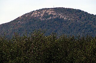
Azure Mountain is a 2,323-foot-tall (708 m) mountain near Blue Mountain Road in the Adirondack Park town of Waverly in Franklin County, New York. Azure Mountain is the site of the Azure Mountain Fire Observation Station, a 35-foot-tall (11 m) steel tower that was built in 1918 and later restored in 2002. The fire tower was listed on the National Register of Historic Places in 2001.

Vanderwhacker Mountain is a 3,389-foot-tall (1,033 m) mountain in the Adirondack Mountains region of New York. It is located northeast of Indian Lake and southeast of Newcomb in Essex County. The Vanderwhacker Mountain Fire Observation Station is located on top of the mountain. In May 1911, the Conservation Commission built a wooden fire observation tower on the mountain which was replaced in 1918, with a 35-foot-tall (11 m) metal tower. The tower stopped fire watching operations at the end of the 1988 season.
Penn Mountain is a 1,808-foot-tall (551 m) mountain in the Tug Hill region of New York. It is located west of East Steuben in the town of Steuben in Oneida County. The mountain is the former site of an 80-foot-tall (24 m) steel fire lookout tower. The tower later ceased fire lookout operations and was removed in 1976.
Whites Hill is a 1,427-foot-tall (435 m) mountain in the northern Adirondack Mountains of New York. It is located southeast of Parishville in St. Lawrence County. The mountain is the former site of an 80-foot-tall (24 m) steel fire lookout tower that was in service from 1951 to 1971.
Crane Mountain is a 3,251-foot-tall (991 m) mountain in the Adirondack Mountains of New York. It is located northwest of Warrensburg in Warren County. The mountain is the former site of a 35-foot-tall (11 m) steel fire lookout tower. The tower was installed in 1918, and later removed in 1987.
Castor Hill is a 1,483-foot-tall (452 m) mountain in the Tug Hill region of New York. It is located east of Greenboro in Oswego County. In 1927, an 80-foot-tall (24 m) steel fire lookout tower was built on the mountain. Due to use of aerial detection the tower was closed at the end of the 1970 fire lookout season, and later removed in 1981.
Fort Noble Mountain is a 2,310-foot-tall (700 m) mountain in the Adirondack Mountains of New York. It is located east-northeast of Nobleboro, on the line between the town of Ohio in Herkimer County and town of Morehouse in Hamilton County. In July 1910, a 30-foot-tall (9.1 m) wood fire lookout tower was built on the mountain. In 1916, it was replaced with a 50-foot-tall (15 m) steel tower. The tower ceased fire lookout operations in 1978, and was later removed.
Catamount Mountain is a 1,814-foot-tall (553 m) mountain in the Adirondack Mountains of New York. It is located southeast of South Colton in St. Lawrence County. In 1917, a 35-foot-tall (11 m) steel fire lookout tower was built on the mountain. The tower ceased fire lookout operations and was later removed in the early 1980s.
Moose River Mountain is a 2,208-foot-tall (673 m) mountain in the Adirondack Mountains of New York. It is located west of Old Forge in the town of Webb in Herkimer County. In 1919, a 60-foot-tall (18 m) steel fire lookout tower was built on the mountain. The tower ceased fire lookout operations at the end of the 1970, and was later removed in 1977.
McCarty Hill is a mountain in the Southern Tier of New York. It is located in Cattaraugus County, mostly in Little Valley and Great Valley, with portions in Ellicottville and Mansfield. In 1940, an 82-foot-6-inch-tall (25.15 m) steel fire lookout tower was built on the mountain. The tower ceased fire lookout operations and then officially closed in early 1989. In 1993, the tower was dismantled and removed and replaced with a free-standing communications tower.
Bald Mountain is a 1,647-foot-tall (502 m) mountain in Lewis County in the state of New York. It is located north of Oswegatchie Camp in the town of Croghan. In 1919, a 47-foot-tall (14 m) steel fire lookout tower was built on the mountain. Due to increased use of aerial detection, the tower was closed at the end of the 1970 season. The tower was later knocked over by the private owner due to liability concerns. The public can visit the site, but due to no tower there is no view.
Boreas Mountain is a 3,780-foot-tall (1,150 m) mountain in the Adirondack Mountains region of New York. It is located west-northwest of North Hudson in Essex County. In 1919, the Conservation Commission built a 47-foot-tall (14 m) steel fire lookout tower on the mountain. Due to increased use of aerial detection, the tower became obsolete and was closed at the end of the 1971 fire lookout season and later removed.
Palmer Hill is a 1,145-foot-tall (349 m) mountain in the Adirondack Mountains region of New York. It is located north of the hamlet of Au Sable Forks in Clinton County. In 1930, the Conservation Department built a 60-foot-tall (18 m) steel fire lookout tower and an observer cabin on the summit. Due to increased use in aerial detection for fire lookout purposes, the tower ceased fire lookout operations in early 1971. It resumed fire watching operations from 1979 to 1988, before being officially closed in early 1989. The tower still remains, but is on private property and is not open to the public.
Makomis Mountain is a 1,631-foot-tall (497 m) mountain located in Adirondack Mountains of New York. It is located west of the hamlet of Witherbee in Essex County. In 1916, a 40-foot-tall (12 m) steel fire lookout tower was built on the mountain. Due to increased use in aerial fire lookout operations, the tower ceased fire lookout operations at the end of the 1970 season, and was later removed.
West Mountain is a 2,923-foot-tall (891 m) mountain located in Adirondack Mountains of New York. It is located in the northwest of the hamlet of Raquette Lake in Hamilton County. In 1920, the Conservation Commission built a 47-foot-tall (14 m) fire lookout tower on the mountain. Due to aerial detection, the tower ceased fire lookout operations at the end of the 1970 season. The tower was later removed, and portions of the tower along with the tower from Kempshall Mountain were used to build the tower that is at the Essex County Historical Museum in Elizabethtown.
Salmon Lake Mountain is a 2,500-foot-tall (760 m) summit located in Adirondack Mountains of New York. It is located west of the hamlet of Long Lake in Hamilton County. Around 1933, a 35-foot-tall (11 m) Aermotor LX24 tower was built on the mountain. The tower was privately owned, but cooperated with the Conservation Commission for fire watching operations. The tower still remains, but is in poor condition and is not open to the public.
Jackie Jones Mountain is a 1,253-foot-tall (382 m) mountain in the state of New York. It is located west of Stony Point in Rockland County. In 1928, a 60-foot-tall (18 m) steel fire lookout tower was built on the mountain. The tower ceased fire lookout operations at the end of the 1988 fire lookout season, and was officially closed in early 1989. The tower is listed on the National Historic Lookout Register, and is open to the public.
Hartzfelt Mountain is a 2,405-foot-tall (733 m) mountain in the Southern Tier of New York. It is located south-southwest of Olean in Cattaraugus County. In 1924, a 60-foot-tall (18 m) steel fire lookout tower was built on the mountain. Due to increased use of aerial detection, the tower ended fire lookout operations at the end of the 1970 fire lookout season, and was later dismantled and removed.
Pharaoh Mountain is a mountain in the Adirondack Mountains region of New York. It is located south of Paradox in Essex County and is contained within the Pharaoh Lake Wilderness Area. The mountain is the highest in the wilderness area, and is located upon the northwest shore of Pharaoh Lake. In April 1910, a fire observation station was established on the mountain but no tower was needed due to lack of tree cover on the mountain. In 1918, a 35-foot-tall Aermotor LS40 tower was built on the mountain. The tower ceased fire watching operations in 1987 and was removed in 1992.

Kempshall Mountain is a 3,350-foot-tall (1,020 m) mountain located in Adirondack Mountains of New York. It is located in the northwest of the hamlet of Long Lake in Hamilton County. In 1918, a 35-foot-tall (11 m) Aermotor LS40 tower was built on the mountain for fire lookout purposes. Due to aerial detection being used, the tower ceased fire lookout operations at the end of the 1971 season. The tower was later removed, and portions of the tower along with the tower from West Mountain were used to build the tower that is at the Essex County Historical Museum in Elizabethtown.

