Saint Regis Mountain

Last updated
St. Regis Mountain from Saint Regis Pond St Regis Mtn from St Regis Pond.jpg
St. Regis Mountain from Saint Regis Pond
View from St. Regis Mountain St Regis Mountain View.jpg
View from St. Regis Mountain

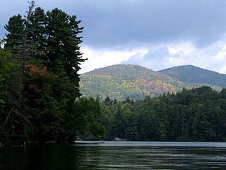
Saint Regis Mountain is a 2,874-foot (876 m) mountain in the town of Santa Clara, New York, in Franklin County at the center of the Saint Regis Canoe Area in the Adirondack Park.

Santa Clara, New York Town in New York, United States

Santa Clara is a town in Franklin County, New York, United States. The population was 345 at the 2010 census. The name was derived from the wife of an early town businessman, John Hurd.

Franklin County, New York county in New York, United States

Franklin County is a county in the northern part of the U.S. state of New York. It borders the Canadian provinces of Quebec and Ontario. As of the 2010 census, the county population was 51,599. Its county seat is Malone. The county is named in honor of United States Founding Father Benjamin Franklin.

Saint Regis Canoe Area

The Saint Regis Canoe Area in Adirondack Park is the largest wilderness canoe area in the Northeastern United States and the only designated canoe area in New York state. It is closed to motorized vehicles. Among the 58 ponds and lakes are Upper Saint Regis Lake, part of the Seven Carries route, and Saint Regis Pond. It contains the headwaters of the West and Middle Branch of the Saint Regis and the Saranac Rivers. Only two of the lakes can be reached without a portage, or carry as it's known in the region. Primitive canoe camping is permitted on many of the lakes and ponds. Saint Regis Mountain and Long Pond Mountain are within the area.

It can be climbed from a trailhead on Keese Mills Road in Keese Mill, west of Paul Smiths. The trail is a gradual 3.3 mile ascent with a gain of 1168 feet. [1]

Keese Mill, New York human settlement in United States of America

Keeses Mills, a.k.a. Keeses Mill and rarely Keese Mill, is a hamlet west of Paul Smiths, New York in the Town of Brighton, Franklin County, New York in the Adirondacks. It is named for a sawmill that was located on the Keeses Mills dam on the Saint Regis River. Keeses Mills road, which starts at Paul Smiths, is the only road in the hamlet; it provides access to Black Pond and Long Pond, trails to Saint Regis and Jenkins Mountains and the Saint Regis Esker Trail, and the middle branch of the Saint Regis River.

Paul Smiths, New York Census-designated place in New York, United States

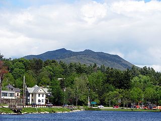
Paul Smiths is a hamlet and census-designated place (CDP) in the Town of Brighton in Franklin County, New York, United States. It is located on Lower Saint Regis Lake in the Adirondacks, 12 miles (19 km) northwest of Saranac Lake, located at 44°26' North 74°15' West. The population of the CDP was 671 at the 2010 census.

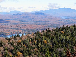
The view from the summit includes thirty lakes, including the Upper and Lower Saranac Lake, and Upper and Lower Saint Regis Lake. [2] The Adirondack High Peaks can also be seen.

Upper Saranac Lake lake in Franklin County, New York, USA

Upper Saranac Lake is one of three connected lakes, part of the Saranac River, in the towns of Santa Clara and Harrietstown, near the village of Saranac Lake in the Adirondacks in northern New York. Upper Saranac Lake is the sixth largest lake in the Adirondacks. With Middle Saranac Lake and Lower Saranac Lake, a 17-mile (27 km) paddle with only one carry is possible. There are 20 primitive campsites accessible by boat available on a first-come basis. Upper Saranac Lake is also known as Sin-ha-lo-nen-ne-pus.

Lower Saranac Lake lake in Franklin County, New York, USA

Lower Saranac Lake is one of three connected lakes, part of the Saranac River, near the village of Saranac Lake in the Adirondacks in northern New York. With Middle Saranac Lake and Upper Saranac Lake, a 17-mile (27 km) paddle with only one portage is possible. The Saranac Lake Islands Public Campground provides 87 campsites on inlands in Lower and Middle Saranac Lake. In addition to the Saranac River, it is fed by nearby Lake Colby, Fish Creek, and Lilly Pad Pond. Lower Saranac Lake is located in the town of Harrietstown, New York. The lake, along with both Upper and Middle Saranac Lakes, is also part of the 740-mile Northern Forest Canoe Trail, which begins in Old Forge, NY and ends in Fort Kent, ME.

The Adirondack High Peaks is the name given to 46 mountain peaks in the Adirondack Mountains of New York, United States that were originally believed to comprise all of the Adirondack peaks higher than 4,000 feet (1,219 m). However, later surveying showed that four of the peaks in the group are actually under this elevation, and one additional peak that is close to this elevation had been overlooked. Due to tradition, no mountains were removed from or added to the group as a result of the revised elevation estimates.

The summit is bare rock, having been cleared by a fire started accidentally by a surveying party led by Verplanck Colvin in 1876. The St. Regis Mountain Fire Observation Station is at the summit was restored in 2016 and is now open to the public.

Verplanck Colvin United States lawyer, author, illustrator and topographical engineer

Verplanck Colvin (1847–1920) was a lawyer, author, illustrator and topographical engineer whose understanding and appreciation for the environment of the Adirondack Mountains led to the creation of New York's Forest Preserve and the Adirondack Park.

St. Regis Mountain Fire Observation Station

The St. Regis Mountain Fire Observation Station is a historic fire observation station located on Saint Regis Mountain at Santa Clara in Franklin County, New York. The station and contributing resources include a 35-foot-tall (11 m), steel frame lookout tower erected in 1918, the site of the former observer's cabin, and 9/10 of a mile foot trail between the cabin site and summit. The tower is a prefabricated structure built by the Aermotor Corporation and provided a front line of defense in preserving the Adirondack Forest Preserve from the hazards of forest fires.

The Adirondack High Peaks from St. Regis Mountain. Mount Marcy is just left of center, Algonquin Peak is to the right High Peaks from St Regis Mtn.jpg
The Adirondack High Peaks from St. Regis Mountain. Mount Marcy is just left of center, Algonquin Peak is to the right

Related Research Articles

Adirondack Mountains Mountain range in northern New York state, USA

The Adirondack Mountains form a massif in northeastern New York, United States. Its boundaries correspond to the boundaries of Adirondack Park. The mountains form a roughly circular dome, about 160 miles (260 km) in diameter and about 1 mile (1,600 m) high. The current relief owes much to glaciation.

Brighton, Franklin County, New York Town in New York, United States

Brighton is a town in Franklin County, New York, United States. The population was 1,435 at the 2010 census. It was named after Brighton, England, by early surveyors in the region.

Hopkinton, New York Town in New York, United States

Hopkinton is a town in St. Lawrence County, New York in the United States. The population was 1,077 at the 2010 census. The town is named for Roswell Hopkins, a pioneer settler.

Paul Smiths Hotel

Paul Smith's Hotel, formally known as the Saint Regis House, was founded in 1859 by Apollos (Paul) Smith in the town of Brighton, Franklin County, New York in what would become the village of Paul Smiths; it was one of the first wilderness resorts in Adirondacks. In its day it was the most fashionable of the many great Adirondack hotels, patronized by American presidents Grover Cleveland, Theodore Roosevelt and Calvin Coolidge, celebrities like P.T. Barnum, and the power elite of the latter half of the 19th century, such as E. H. Harriman and Whitelaw Reid. Smith died in 1912, but the hotel continued under his son, Phelps, until it burned down in 1930.

Lake Clear is a hamlet and a lake in Franklin County, New York, United States. The area is named for 940-acre (3.8 km2) Lake Clear, part of the original Seven Carries canoe route. It is located in the town of Harrietstown.

Upper St. Regis Lake lake of the United States of America

742-acre (3.00 km2) Upper St. Regis Lake is a part of the St. Regis River in the Adirondacks in northern New York State. Along with Lower St. Regis Lake and Spitfire Lake, it became famous in the late 19th century as a summer playground of America's power elite, drawn to the area by its scenic beauty and by the rustic charms of Paul Smith's Hotel. It is the site of many grand old summer "cottages" and Great Camps, including Marjorie Merriweather Post's Topridge. Frederick W. Vanderbilt, Anson Phelps Stokes and Whitelaw Reid were among the summer residents. "The camps of many of these families began as tent colonies, with separate units for sleeping, dining, games, and so on, and evolved into permanent structures built with understated taste."

Lower St. Regis Lake

350-acre (1.4 km2) Lower St. Regis Lake is a part of the St. Regis River in the Adirondacks in northern New York State. At its northern edge is Paul Smith's College, former site of Paul Smith's Hotel. Along with Upper St. Regis Lake and Spitfire Lake, it became famous in the late 19th century as a summer playground of America's power elite, drawn to the area by its scenic beauty and by the rustic charms of Paul Smith's Hotel. It is the site of a small chapel, originally built of logs, St. John's in the Wilderness, that was formerly attended by well-dressed families that arrived in canoes, rowboats and sailboats.

Spitfire Lake

250-acre (1.0 km2) Spitfire Lake is a part of the St. Regis River in the Adirondacks in northern New York State. Along with Upper and Lower St. Regis Lake, it became famous in the late 19th century as a summer playground of America's power elite, drawn to the area by its scenic beauty and by the rustic charms of Paul Smith's Hotel. It is the site of many grand old summer "cottages" and Great Camps; Frederick W. Vanderbilt, Anson Phelps Stokes and Whitelaw Reid were among the summer residents. "The camps of many of these families began as tent colonies, with separate units for sleeping, dining, games, and so on, and evolved into permanent structures built with understated taste."

Saint Regis Pond

Saint Regis Pond is a 400-acre (1.6 km2) pond, the largest in the Saint Regis Canoe Area in the Adirondacks in northern New York state. It drains into the west branch of the St. Regis River. It is the centerpiece of the "Seven Carries" canoe route.

Sawteeth (New York) mountain in United States of America

Sawteeth is a mountain located in Essex County, New York. The mountain is part of the Great Range of the Adirondack Mountains. The mountain's name comes from the serrated appearance of its summit ridge. Sawteeth is on a spur ridge of the Great Range, which branches off to the southeast from Gothics.

Nye Mountain is a mountain located in Essex County, New York, named after William B. Nye (c.1815–1893), an Adirondack mountain guide. Nye Mountain is part of the Street Range of the Adirondack Mountains; it is flanked to the southwest by Street Mountain.

Hogansburg is a hamlet, in Franklin County, in the Town of Bombay in New York state, United States. It lies on NY 37 near the Canadian-US border at the confluence of the St. Regis River with the Saint Lawrence Seaway. Hogansburg borders the St. Regis Mohawk Reservation.

Ampersand Mountain mountain in United States of America

Ampersand Mountain is a 3,352 ft (1,021.7 m) mountain in Franklin County in the northeastern Adirondacks, west of the High Peaks in New York State. The trail up the mountain begins on New York State Route 3 8.1 miles (13.0 km) southwest of the village of Saranac Lake, near Middle Saranac Lake; it is a popular day hike. The mountain takes its name from nearby Ampersand Creek, so named because it twists and turns like the ampersand symbol. The summit is bare rock, with extensive views of the High Peaks to the east and the Saranac Lakes to the west. Stony Creek Mountain is located west-southwest of Ampersand Mountain.

St. Johns in the Wilderness Episcopal Church

St. John's in the Wilderness Episcopal Church is an Episcopal church in Paul Smiths in the Adirondacks, New York State, United States. It was founded in 1876 by Dr. Edward Livingston Trudeau with the help of Paul Smith and many of the wealthy camp owners around Spitfire, Upper, and Lower Saint Regis Lakes. The original log building burned in 1928, and was replaced by the present structure, designed by William G. Distin, in 1930. The non-denominational cemetery surrounding the church contains the graves of Dr. Trudeau, Paul Smith, Charles Minot Dole, Clifford R. Pettis and several other notable residents of the area.

Azure Mountain mountain in United States of America

Azure Mountain is a 2,518-foot (767 m) mountain near Blue Mountain Road in the Town of Waverly, Franklin County, New York, in the Adirondack Park in the US.

McKenzie Mountain mountain in United States of America

McKenzie Mountain is a 3,861-foot (1,177 m) mountain in western Essex County in the towns of St. Armand and North Elba in the Adirondack Park, a unit of the Forest Preserve.

Owls Head Mountain

Owls Head Mountain is a 2,812-foot (857 m) mountain in Long Lake, New York in the Adirondack Park.

Loon Lake Mountain is a 3328-foot mountain near Loon Lake in Franklin County, New York. On the summit is the Loon Lake Mountain Fire Observation Station, which was added to the National Register of Historic Places in 2015.

References

Coordinates: 44°24′30″N74°19′47″W / 44.40833°N 74.32972°W / 44.40833; -74.32972

Geographic coordinate system Coordinate system

A geographic coordinate system is a coordinate system that enables every location on Earth to be specified by a set of numbers, letters or symbols. The coordinates are often chosen such that one of the numbers represents a vertical position and two or three of the numbers represent a horizontal position; alternatively, a geographic position may be expressed in a combined three-dimensional Cartesian vector. A common choice of coordinates is latitude, longitude and elevation. To specify a location on a plane requires a map projection.