
Franklin County is a county on the northern border of the U.S. state of New York. To the north across the Canada–United States border are the Canadian provinces of Quebec and Ontario, from east to west. As of the 2020 census, the county population was 47,555. Its county seat is Malone. The county is named in honor of United States Founding Father Benjamin Franklin.

An esker, eskar, eschar, or os, sometimes called an asar, osar, or serpent kame, is a long, winding ridge of stratified sand and gravel, examples of which occur in glaciated and formerly glaciated regions of Europe and North America. Eskers are frequently several kilometres long and, because of their uniform shape, look like railway embankments.
Bellmont is a town in Franklin County, New York, United States. The town is on the eastern border of the county and is southeast of Malone. The population was 1,434 at the 2010 census. The town is named after William Bell, a major landowner in the early history of the town.

Brighton is a town in Franklin County, New York, United States. The population was 1,435 at the 2010 census. It was named after Brighton, England, by early surveyors in the region.
Duane is a town in Franklin County, New York, United States. The population was 174 at the 2010 census. The town is named after James Duane, a developer and grandson of New York City mayor James Duane.

Harrietstown is a town in Franklin County, New York, United States. The total population was 5,254 at the 2020 census, In 2010 3,879 of the town's residents lived in the village of Saranac Lake on the eastern side of the town.

Santa Clara is a town in Franklin County, New York, United States. The population was 345 at the 2010 census. The name was derived from the wife of an early town businessman, John Hurd.

Colton is a town in St. Lawrence County, New York, United States. The population was 1,451 at the 2010 census. The town, originally named "Matildaville", is named after early settler Jesse Colton Higley.

Hopkinton is a town in St. Lawrence County, New York, United States. The population was 1,105 at the 2020 census and has a Population density of 5.9 square miles. The town is named for Roswell Hopkins, a pioneer settler and a government official.
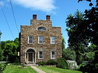
Keeseville is a hamlet in Clinton and Essex counties, New York, United States. The population was 1,815 at the 2010 census. The hamlet was named after the Keese family, early settlers from Vermont. It developed along the Ausable River, which provided water power for mills and industrial development.
The Adirondack Park is a part of New York's Forest Preserve in northeastern New York, United States. The park was established in 1892 for "the free use of all the people for their health and pleasure", and for watershed protection. The park's boundary roughly corresponds with the Adirondack Mountains. Unlike most state parks, about 52 percent of the land is privately owned inholdings. State lands within the park are known as Forest Preserve. Land use on public and private lands in the park is regulated by the Adirondack Park Agency. This area contains 102 towns and villages, as well as numerous farms, businesses and an active timber-harvesting industry. The year-round population is 132,000, with 200,000 seasonal residents. The inclusion of human communities makes the park one of the great experiments in conservation in the industrialized world. The Forest Preserve was designated a National Historic Landmark in 1963.

The Saint Regis Canoe Area in Adirondack Park is the largest wilderness canoe area in the Northeastern United States and the only designated canoe area in New York state. It is closed to motorized vehicles. Among the 50 ponds and lakes are Upper Saint Regis Lake, part of the Seven Carries route, and Saint Regis Pond. It contains the headwaters of the West and Middle Branch of the Saint Regis and the Saranac Rivers. Only two of the lakes can be reached without a portage, or carry as it is known in the region. Primitive canoe camping is permitted on many of the lakes and ponds. Saint Regis Mountain and Long Pond Mountain are within the area.

Paul Smiths is a hamlet and census-designated place (CDP) in the town of Brighton in Franklin County, New York, United States. It is located on Lower Saint Regis Lake in the Adirondacks, 12 miles (19 km) northwest of Saranac Lake, located at 44°26' North 74°15' West. The population of the CDP was 671 at the 2010 census.
Lake Clear is a hamlet and a lake in Franklin County, New York, United States. The area is named for 940-acre (3.8 km2) Lake Clear, part of the original Seven Carries canoe route. It is located in the town of Harrietstown.
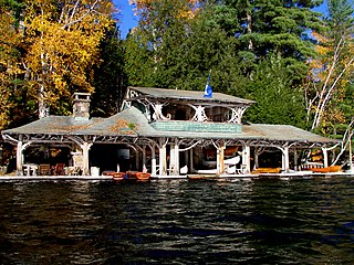
Camp Topridge is an Adirondack Park Great Camp bought in 1920 and substantially expanded and renovated in 1923 by Marjorie Merriweather Post, founder of General Foods and the daughter of C. W. Post. The "camp", near Keese Mill, in the U.S. state of New York, was considered by Post to be a "rustic retreat"; it consisted of 68 buildings, including a fully staffed main lodge and private guest cabins, each staffed with its own butler. It was one of the largest of the Adirondack great camps and possibly the most elaborately furnished.
The Seven Carries is an historic canoe route from Paul Smith's Hotel to the Saranac Inn through what is now known as the Saint Regis Canoe Area in southern Franklin County, New York in the Adirondack Park. The route was famous with sportsmen and tourists from major east-coast cities from the late 19th century through the 1930s; interest has revived in recent years. Despite the name, the route consists of only six carries, or portages.

Franklin Falls Pond is a 439-acre (178 ha), 2.7-mile (4.3 km) long pond created by damming the Saranac River three miles (5 km) northeast of Lower Saranac Lake in the Adirondack Mountains of northern New York State. The pond is also part of the 740-mile Northern Forest Canoe Trail, which begins in Old Forge, NY and ends in Fort Kent, ME.
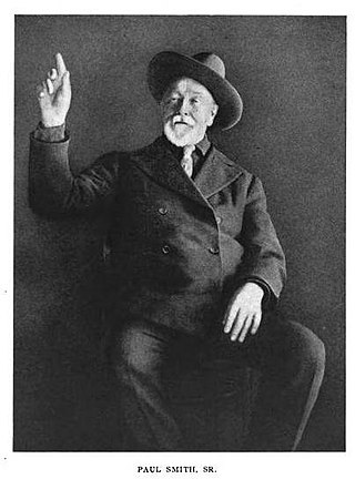
Apollos "Paul" Smith (1825–1912) was an American hunting and fishing guide from Vermont who founded the Saint Regis House in the Town of Brighton, New York, in the Adirondack Mountains. It was known universally as Paul Smith's Hotel, one of the first wilderness resorts in the Adirondacks. In its day, it was the most fashionable of the many great Adirondack hotels, patronized by American presidents, celebrities, and the power elite of the latter half of the 19th century. It was a large operation, with 255 rooms, stables, and many other amenities.
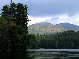
Saint Regis Mountain is a 2,838-foot-tall (865 m) mountain in the town of Santa Clara, New York, in Franklin County at the center of the Saint Regis Canoe Area in the Adirondack Park.
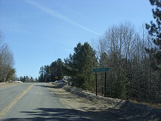
Skerry is a hamlet in the town of Brandon in Franklin County, New York, United States. It is located east of the Little Salmon River on Franklin County Highway 12 and Franklin County Highway 13. Skerry is 9 miles (14 km) southwest of Malone and 5 miles (8 km) southeast of West Bangor.


